
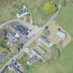
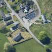
Kilmichael Glassary, Kilmichael Glassary Parish Church, Churchyard


Burial Ground (Medieval), Churchyard (Medieval), Cross Slab (Early Medieval), Grave Slab(S) (Medieval)
Site Name Kilmichael Glassary, Kilmichael Glassary Parish Church, Churchyard
Classification Burial Ground (Medieval), Churchyard (Medieval), Cross Slab (Early Medieval), Grave Slab(S) (Medieval)
Canmore ID 39547
Site Number NR89SE 15.01
NGR NR 85898 93521
Datum OSGB36 - NGR
Permalink http://canmore.org.uk/site/39547


- Council Argyll And Bute
- Parish Kilmichael Glassary
- Former Region Strathclyde
- Former District Argyll And Bute
- Former County Argyll
NR89SE 15.01 85898 93521
See also NR89NW 54.
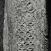
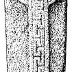
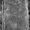
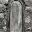
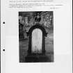
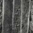
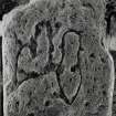
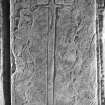
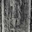
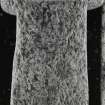
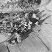
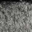
(NR 85898 93521) There are many fine medieval gravestones in the graveyard around Kilmichael Glassary church, built c.1820. Earlier crosses comprise (i) immediately S of the gate, the second grave is covered by a prostrate cross, with short arms, undecorated and with the name Archd MacCallum incised. Its shape suggests an early date. It is very thick, and buried to its full thickness, so no carving can be felt underneath. (ii) N of the gate in the first row, opposite the church gable, a short slab eked with another to make up the normal length bears a wheel-headed cross with a slightly expanded shaft filled with greek-key patterns. This was the principal church of the Lordship of Glassary after c.1563 (See also NR89NW 54).
M Campbell and M Sandeman 1964.
Field Visit (8 May 1973)
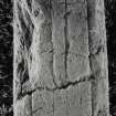
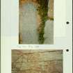
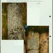
NR 8588 9351: The medieval grave-slabs are partially turf-covered, but generally as described.
Visited by OS (DWR), 8 May 1973.
Field Visit (June 1988)
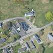
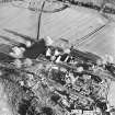
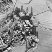
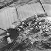
The church of Glassary parish stands in a rectangular churchyard on the W side of the valley of the River Add, l20m E of an extensive rock-outcrop with cup-and-ring markings, and 170m N of the manse that was built in 1841 to replace a building of 1767 (en.1). The celebrated Romanesque shrine containing an early iron bell, now in the Royal Museum of Scotland, is believed to have been found about 1814 in the area between the church and manse rather than at Torbhlaren, 0.8km to the NE, as originally reported (en.2).
The name Kilmichael is recorded about 1315 ('Kylmyel in Glenod'), and possibly also in 1240, while about 1350 it was named in association with the adjacent property of Cross Gillesbuig ('Archibald's Cross’) (en.3*). In the late middle ages it was evidently an important place of burial, but it remained a chapel-at-ease of Kilneuair (No.81) until about the early 17th century. The division of the extensive parish, extending from Loch Awe to Loch Fyne, was proposed in 1642, and in 1651 it was decided to establish new parish churches at Kilneuair and on Lochfyneside. Although no action was taken, a similar division based on Kilneuair and Killevin (No.63) was proposed in the early 19th century, when a mission was established on Lochfyneside. In addition to theParliamentary church built at Lochgilphead (No.l72) in 1828, a mission chapel was founded at Cumlodden (NS014994) in 1841 and erected into a quoad sacra parish in 1853,and later chapels were built at Lochgair (NR 922905) and Ford (NM 869036) (en.4).
Little is known of the early buildings, although Sir James Campbell of Auchenbreck, principal heritor, submitted a petition about rebuilding the church to the Synod of Argyll in 1725. The church was described in 1794 as having once been 'among the best in the county', but was inconvenient because it was 'long and narrow'. Proposals for repairs were made in 1815, and four years later it was agreed that the old church, even with galleries, would not accommodate 400 sitters. A plan by George Johnston for a church measuring 22.7m by 12.8m, to seat 800, was accepted in 1819, and an estimate of £1138 obtained, but the heritors took no action and uncertainty about the effect of the new church at Lochgilphead on congregational numbers delayed its execution. New plans were obtained in 1826 from John and Donald McIsaac for a church costing £948, and work began the following year, being completed in 1828. The building, which was said in 1844 to be 'too large', was damaged by lightning and repaired in 1830. It is said to have been 'taken down and rebuilt on a scale better suited to the population' in 1873 (en.5).
The existing building is a rectangle measuring 14.7m by 9.9m, with four lancets in the N side-wall and three lancets and an entrance-porch to the S. At the centre of the W gable wall there is a small three-stage tower with pyramidal slated roof, having a shield with the date 1872 in the w wall. At the E end there is a shallow gabled extension with a round-headed window, probably added early in the 20th century. The internal furnishings are of the same period, and the bell is dated 1910.
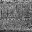
ARCHITECTURAL FRAGMENT. A damaged window-sill or lintel, probably of late 16th- or 17th-century date, has been re-used as a grave-cover near the S wall of the churchyard. It is a slab of schist 1.07m by 0.31m by 0.11m in thickness, having splayed ingoes and a chamfered outer sill for a daylight-opening 0.73m wide and wrought with a 35mm chamfer, and bearing a glazing-groove.
RCAHMS 1992, visited June 1988
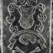
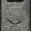
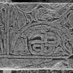
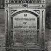
[see RCAHMS 1992 No. 69 for a detailed description of 39 funerary monuments and crosses in the churchyard]
Reference (2001)
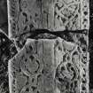
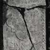
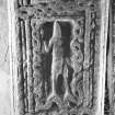
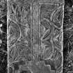
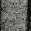
Slab, 1.44m by 0.42m, bearing in relief a ringed Latin cross with a beaded margin and round sunken armpits. The shaft bears a fret-pattern which appears to have been continued in the cross-arms and ring.
I Fisher 2001.
Desk Based Assessment (January 2009)
In January 2009 Kilmartin House Museum conducted a Desk Based Survey (DBA) on the church and graveyard of Kilmichael Glassary. The aim of the report was to locate and compile all known information on the church and graveyard. The collated information will to be used as a basis for the survey and recording of the gravestones within the graveyard. The project was undertaken in partnership with the Dunadd Historic Graveyard Group, Historic Scotland, the Church of Scotland and Argyll and Bute District Council. The project is part of the Dalraida Project which is the major funder.

