
Ballymeanoch


Kerb Cairn (Prehistoric)
Site Name Ballymeanoch
Classification Kerb Cairn (Prehistoric)
Canmore ID 39483
Site Number NR89NW 40
NGR NR 83395 96429
Datum OSGB36 - NGR
Permalink http://canmore.org.uk/site/39483


- Council Argyll And Bute
- Parish Kilmichael Glassary
- Former Region Strathclyde
- Former District Argyll And Bute
- Former County Argyll
NR89NW 40 83395 96429.
(NR 8340 9641) Cairn (NR)
OS 6" map, Argyllshire, 2nd ed., (1900)
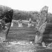
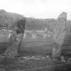
A ring of erect slabs, 17' in diameter, average height 3' (Campbell and Sandeman 1964) apparently the remains of the retaining wall of a barrow (information and photograph from G E Livock to OS, 1940).
M Campbell and M Sandeman 1964.
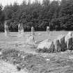
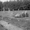
This is kerbed cairn comprising 11 stones. The interior contains recent field clearance.
Resurveyed at 1:2500.
Visited by OS (I A) 2 May 1973.
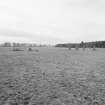
NR 8340 9642. The remains of a kerbed cairn surviving as 11 earthfast slabs forming a circle 6.0m diameter enclosing a turf-covered stony mound 0.6m high. The slabs are almost continuous in the north quadrant but only a few remain elsewhere. In the west, two large stones lying adjacent to, and outside the circle appear to have been originally part of the kerb.
Surveyed at 1/10,000.
Visited by OS (T R G) 4 April 1977.
Field Visit (June 1979)
About 135 m to the WNW of NR89NW 51, at the corner of an arable field and 29 m NE of the standing stones (NR89NW 14), there is a kerb-cairn (Campbell and Sandeman 1964, No. 66). A drainage ditch has removed a small portion of the E arc of the cairn, but originally it was roughly circular on plan, measuring about 6.9 m in diameter over a kerb of upright boulders, and it now stands to a height of 0.7 m. Stone-robbing has reduced the number of kerbstones to eleven, and several of the remainder survive only as stumps; the stones of the kerb, however, appear to have been graded in height, with the tallest (up to 1.4 m high) on the SW.
Visited June 1979
RCAHMS 1988

