
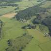
Ballymeanoch


Cist (Period Unassigned), Henge (Neolithic) - (Bronze Age), Beaker (Period Unassigned)
Site Name Ballymeanoch
Classification Cist (Period Unassigned), Henge (Neolithic) - (Bronze Age), Beaker (Period Unassigned)
Canmore ID 39458
Site Number NR89NW 18
NGR NR 83317 96277
Datum OSGB36 - NGR
Permalink http://canmore.org.uk/site/39458


- Council Argyll And Bute
- Parish Kilmichael Glassary
- Former Region Strathclyde
- Former District Argyll And Bute
- Former County Argyll
NR89NW 18 8331 9627.
(NR 8331 9628) Circle (NR) (Cists found)
OS 6" map, (1924)
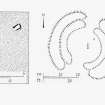
This feature, excavated in 1864 by Greenwell, consists of a low cairn 72' in diameter with two cists. One, near the centre, measures 8' x 3' x 2'; no finds were made in it. The other, 10' NNE of centre, measures 3' x 1'4" x 1'10". It contained a beaker, now in the British Museum, and teeth from three bodies.
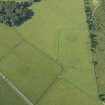
The cairn is surrounded by the ditch of a Class 2 henge, 115' in diameter, 7' - 12' wide with causeways at E and W. The external bank is 138' in diameter, 24' - 28' wide.
M Campbell and M Sandeman 1964; W Greenwell 1868; H A W Burl 1969; J H Craw 1931.
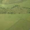
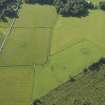
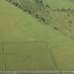
At this site are the remains of a Class 2 henge which consist of a ditch up to 6.0m wide and 0.5m deep enclosing an area 20.0m in diameter. The mutilated causeways are in the N and S. There is a stony outer bank, most obvious on the E side.
Only the larger cist is visible in the interior which, although stony, cannot be confirmed as a cairn because field clearance has been deposited over the whole site.
Resurveyed at 1:2500.
Visited by OS (J P) 21 June 1973.
NR 8332 9627. An earthwork generally as described by the previous authorities. The inner top edge of the bank has a 'kerb' of intermittent, earthfast stones; four of these are particularly large being up to 0.6m by 0.4m.
The interior is completely covered by a cairn, composed of small stone, which rises to a height of 0.6m above the surrounding ground level. In its top, are two cists which are off-centre. The larger of these is complete with capstone whilst the smaller is open. The earthwork is turf-covered and has clear evidence of disturbance, with modern stone clearance infilling parts of the ditch.
It is almost certainly a Class 2 henge with, in the interior, a large cairn which has two apparently secondary cists.
Surveyed at 1/10,000.
Visited by OS (T R G) 19 April 1977.
Measured Survey (26 June 1979)
RCAHMS surveyed Ballymeanoch henge monument on 26 June 1979 with plane-table and alidade producing a plan at a scale of 1:100. The plan of the cairn was redrawn in ink and published at a scale of 1:250 (RCAHMS 1988a, 52).
Field Visit (June 1981)
This henge monument is situated in an unploughed part of a field 150 m to the SSW of the standing stones No.199; it comprises an outer bank with internal ditch, broken by entrance-causeways on the N and S, and has two cists within the enclosed area. The henge measures about 40 m in diameter overall, but the bank, at best 0.4 m high, is so denuded that its edge is now uncertain; the flat-bottomed ditch is about 4 m across and at most about 0.4 m in depth.
Two cists were discovered in the course of Greenwell's excavations in 1864, both of them still partly visible.1 The larger and more central cist (1.8 m by 0.8 m and 0.7 m in depth) was constructed with unusually long side-slabs (up to 2.75 m) and is still covered by a massive capstone (2.4 m by 1.4 m and 0.25 m thick). The floor of the cist was formed of carefully laid small rounded pebbles. It had apparently been rifled before Greenwell's excavation, and nothing further was found in it.
In the NE quadrant of the interior three stones remain of a second cist; this was still complete in 1864, comprising four slabs and a cover, and measuring 0.9 m by 0.4 m and 0.5 m in depth. It contained the remains of three inhumation burials, accompanied by a fragmentary Beaker; the pot is now in the British Museum, London.
Visited June 1979
RCAHMS 1988
Excavation (1995)
NR 833 962 and NR89NW 14 (Ballymeanoch standing stones)
During April 1995 landscape work was carried out at these sites in order to improve their appearance. This involved the removal of modern clearance stone and the addition of topsoil to cover plough damage on the ground immediately around the monuments. In addition a trench was excavated at the site in order to test the nature of some geophysical anomalies which had been detected in 1993.
Whilst removing the modern clearance stone from around the bases of stones A-D (RCAHMS 1988) nothing of additional archaeological interest was encountered. Amongst the clearance stone aound the bases of Stones E and F (RCAHMS 1988) were two large flat stones; one measured 0.78m by 0.43m and in one of its corners are two possible eroded cup-marks. The other stone measured 0.66m by 0.32m and was thinner and squarer with a dressed appearance. Both stones were left in situ.
When clearance stones were removed from the ditch around the henge on its W side a large flat stone measuring 1.2m by 0.5m was found. It is suspected that this is the missing northern end slab from the central cist in the Henge. Another smaller, flatter, and much squarer stone was also found in this area of the ditch. It measures 0.5m by 0.3m and may have originally come from the satellite cist. Both stones were left in situ.
Geophysical prospection in 1993 had detected a series of linear anomalies on the same alignment as Stones A-D (RCAMS 1988) and running up to meet them at their SE end. A 50m by 1m trench was excavated across these anomolies as there is a good case to suggest that they represent the remains of a prehistoric earthwork avenue. There were no archaeological deposits encountered that might explain the cause of the linear anomalies but a ditch was encountered running N-S. It measured an average of 0.6m across and when sectioned proved to be only an average of 0.11m in depth. No finds were recovered but the W side of this feature contained more stone than the E possibly indicating the presence of packing material for a palisade trench.
Sponsor: Commissioned by Historic Scotland and funded by Kilmartin Glen Project.
D Abernethy 1995.

