
Loch Leathan


Crannog (Period Unassigned)(Possible), Island Dwelling (Medieval)
Site Name Loch Leathan
Classification Crannog (Period Unassigned)(Possible), Island Dwelling (Medieval)
Canmore ID 39430
Site Number NR89NE 11
NGR NR 8745 9835
Datum OSGB36 - NGR
Permalink http://canmore.org.uk/site/39430


- Council Argyll And Bute
- Parish Kilmichael Glassary
- Former Region Strathclyde
- Former District Argyll And Bute
- Former County Argyll
NR89NE 11 8745 9835.
(NR 8742 9836) Pile of Stones (NAT)
OS 6" map, Argyllshire, 2nd ed., (1900)
An artificial island, traditionally said to have been a place of refuge. Tradition also says that there was a castle on this island in 1647 (Campbell 1885) but no reference to such could be found in the Glassary charters (Campbell and Sandeman 1964).
Name Book 1871; Lord A Campbell 1885; M Campbell and M Sandeman 1964.
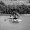
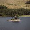
An artificial island composed of small boulders. It is about 6-7m in diameter and protrudes c. 1.0m above the level of the loch. Viewed from the above, there is no apparent trace of a building on it and no evidence of a causeway was found. No further information could be found but from its construction it is quite possible that this is a crannog.
Visited by OS (RD) 17 March 1970
Field Visit (June 1981)
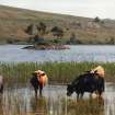
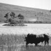
This small stony island in the middle of Loch Leathan appears to be partly artificial in origin. It has a boulder strewn shoreline and there is a boat-inlet in the NE sector. The low summit-area is occupied by the foundations of a building of indeterminate, but probably originally rectangular plan, which has been considerably altered at the S end by the construction of three duck-shooting hides in modern times. A tradition relating to an episode in 1647, when Alasdair MacDonald was fired upon with arrows from this island, suggests that it was considered to be a 'castle' at that period; but there are no surviving remains to confirm that it has been fortified to any degree. A conventional building is shown on the island on Pont's map of about 1590 (en.2).
RCAHMS 1992, visited June 1981
Archaeological Evaluation (2003)
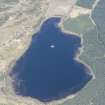
NR 8745 9835 The crannog is visible above water as a large boulder mound, with trees and bracken growing on the dry areas. The island is 119m from the W shore of the loch, and in c 1.2m of water; around 20% of the site is submerged. The basal diameter of the mound is 22m, while the diameter of the dry area is 15m. The height of the site from base to highest point is 3m. There is no causeway between the site and the shore, and no evidence of natural foundations to the site.
Snorkel and diving inspection encountered many structural timbers around the site, though most of these were located beneath c 10-30cm of soft lacustrine silt. A worked trough timber, c 2m long, was noted on the W side of the site. Another large, partially hollowed timber, c 4m long and resembling an unfinished log boat, was located on the SE edge of the site. Many other horizontal timbers, some with tool markings, could be felt beneath the shallow silt deposits. The majority of these were not protruding from the boulder mound but appeared to represent structural timbers which had fallen into the loch around the site. Three oak piles were, however, noted protruding from the loch bed at the SW corner of the site. There is no indication from surface inspection that the main boulder mound incorporates any organic structural element.
Several stone structures have been constructed on top of the main boulder mound, and although some of these appear to be of relatively modern origin there is evidence of cellular structures constructed within the boulder mound which may be original features. Three boat noosts have been constructed on the site, at the S, W and NE sides, though only the latter is likely to be original.
A probable pivot stone, c 40cm in diameter, was located near the NE boat noost. Underwater, fragments of burnt bone and several cattle teeth were found in the loch bed silts, as well as one short plank timber which had two holes drilled through it, and was grooved along one edge. A fragment of green-glazed pottery was also recovered from the submerged area, suggesting that one phase of use of the site may have occurred in the 13th or 14th centuries AD.
Full report has been lodged with the NMRS.
Sponsors: Dr J N Marshall (Isle of Bute) Memorial Fund, CBA Challenge Funding, University of Nottingham.
M G Cavers 2003

