|
Photographs and Off-line Digital Images |
A 74974 |
|
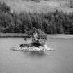
Loch Leathan, Crannog.
General view from North-West. |
1987 |
Item Level |
|
|
Photographs and Off-line Digital Images |
A 74975 CN |
|
Loch Leathan, Crannog.
General view from North-West. |
1987 |
Item Level |
|
|
Photographs and Off-line Digital Images |
A 74976 |
|
Loch Leathan, Crannog.
General view from West. |
1987 |
Item Level |
|
|
Photographs and Off-line Digital Images |
A 74977 CN |
|
Loch Leathan, Crannog.
General view from West. |
1987 |
Item Level |
|
 |
On-line Digital Images |
SC 672954 |
|
Scanned image of Loch Leathan, Crannog. General view from North-West. |
1987 |
Item Level |
|
|
Manuscripts |
MS 2275 |
|
The Argyll Crannog Survey 2003 by M Graeme Cavers, University of Nottingham. |
2003 |
Item Level |
|
 |
Digital Files (Non-image) |
WP 003837 |
Publications by the Royal Commission on the Ancient and Historical Monuments of Scotland |
Argyll: An inventory of the monuments: volume 7: Mid-Argyll and Cowal: Medieval and later monuments |
1992 |
Item Level |
|
 |
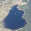
On-line Digital Images |
DP 252888 |
Historic Environment Scotland |
Oblique aerial view. |
3/5/2017 |
Item Level |
|
 |
On-line Digital Images |
DP 252889 |
Historic Environment Scotland |
Oblique aerial view. |
3/5/2017 |
Item Level |
|
 |
On-line Digital Images |
SC 2260095 |
|
Loch Leathan, Crannog.
General view from North-West. |
1987 |
Item Level |
|
 |
On-line Digital Images |
SC 2260096 |
|
Loch Leathan, Crannog.
General view from West. |
1987 |
Item Level |
|
 |
On-line Digital Images |
SC 2260097 |
|
Loch Leathan, Crannog.
General view from West. |
1987 |
Item Level |
|
 |
On-line Digital Images |
SC 2417995 |
Records of the Ordnance Survey, Southampton, Hampshire, England |
Loch Leathan, NR89NE 11, Ordnance Survey index card, Recto |
c. 1958 |
Item Level |
|
 |
On-line Digital Images |
SC 2417996 |
Records of the Ordnance Survey, Southampton, Hampshire, England |
Loch Leathan, NR89NE 11, Ordnance Survey index card, Recto |
c. 1958 |
Item Level |
|
|
All Other |
551 166/1/1 |
Records of the Ordnance Survey, Southampton, Hampshire, England |
Archaeological site card index ('495' cards) |
1947 |
Sub-Group Level |
|


