Kilbride, St Bride's Chapel
Chapel (Medieval)
Site Name Kilbride, St Bride's Chapel
Classification Chapel (Medieval)
Alternative Name(s) Rhudil Glen, Kilbride Church
Canmore ID 39428
Site Number NR89NE 1
NGR NR 85096 96688
Datum OSGB36 - NGR
Permalink http://canmore.org.uk/site/39428
- Council Argyll And Bute
- Parish Kilmichael Glassary
- Former Region Strathclyde
- Former District Argyll And Bute
- Former County Argyll
NR89NE 1 8509 9668.
(NR 8509 9668) St Bride's Chapel (NR) (In Ruins)
OS 6" map, Argyllshire, 2nd ed., (1900)
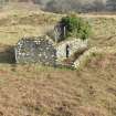
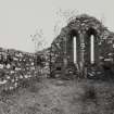
St Bride's Chapel, now roofless, is of uncertain date, possibly c. 1300. It is a simple oblong on plan, rubble-walled and gabled. The floor is grass-grown, and a dry-stone dyke forms a narrow enclosure on the entrance side (SDD 1960-). There is an 18th century memorial tablet to the Campbells of Rudale in the W gable, which explains the good preservation of the building (Campbell and Sandeman 1964).
The chapel was in use until the Reformation.
SDD 1960-; M Campbell and M Sandeman 1964; M Campbell 1961.
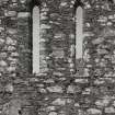
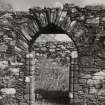
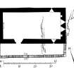
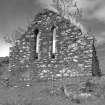
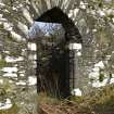
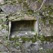
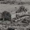
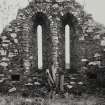
The remains of St Bride's Chapel stand to roof height and measure 13.2m E-W by 6.9m over walls 0.9m wide of roughly coursed masonry and pinnings bonded with lime mortar. There are two lancet windows in the E gable and one at the E end of the N and S walls. There is an arched entrance in the W end of the S wall, and two communion aumbries in the E wall.
Visited by OS (RD) 21 October 1971.
Field Visit (April 1985)
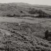
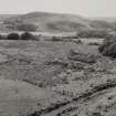
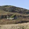
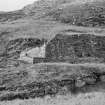
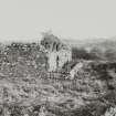
The roofless shell of the medieval chapel of St Bridget or Bride occupies a low rocky knoll at the SW end of an area of former rig-cultivation on a terrace some 35m above the valley of the Rhudil Burn, and 250m NW of Kilbride farmhouse.
The site is bounded to the NE and NW by a 19th-centuryfield-dyke and a bridle-track ascending the steep hillside of Cnoc an Aingil, and to the SE and SW by ground which falls in a series of low rock- faces. There are slight traces, especially to the SE and NE, of an earlier drystone wall enclosing an area about 30m in diameter, but this is much interrupted by low spines of rock, one of which runs through the chapel itself. Some 10m W of the chapel there is the outline of a subrectangular building measuring 5.5m from NW to SE by3.3m within 1m walls. Although it is possible that this was an earlier chapel, it appears to lie outside the older enclosure and, like a similar building a few metres to the w, it was probably a domestic building of post-medieval date.
An Early Christian origin for the site is suggested by the discovery of a cross-slab at Kilbride farmhouse (No. 55).Although no early references to the existing building have been identified, its architectural characteristics suggest a13th-century date, and it was evidently a dependent chapel within the parish of Glassary, whose church was at that period at Kilneuair (No. 81). The building was used in the18th and 19th centuries as a burial-place for the Campbell family of Rhudil, and the masonry was extensively repointed, probably about 1900. The rebuilding of the door head, and the construction against the S wall of a small enclosure to exclude animals, probably belong to the same period.
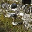
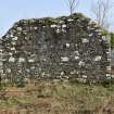
The chapel measures 11.1m by 5.1m within walls which varyfrom 0.85m to 1m in the gables; the E end-wall, which surmounts a rock-outcrop, is carried on a slight external plinth. Whereas the E gable stands to its full height, the W gable and side-walls have been slightly reduced. The masonry is of rubble, intermittently coursed, and the local schist has been neatly dressed for the door- and window-surrounds, some blocks retaining traces of diagonal tooling. Most of the visible mortar pointing is of recent character, but the sheltered ingoes of the E and S windows preserve considerable remains of medieval plaster.
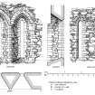
The entrance-doorway is at the W end of the S wall; its 0.l3m roll-moulded jambs, splayed ingoes and flat rear-lintel appear to be undisturbed medieval work, but the two-centred rubble arch-head is probably of recent construction. The chancel, which has two small aumbries in the E wall and another below the window in the S wall, is distinguished from the featureless nave by a rise in floor-level due to rock outcropping in the E part of the chapel. It was lit by two tall and well-preserved lancets in the E wall, and by smaller windows, which have lost their arch-heads, towards the E ends of the side-walls. All of these openings are wrought chamfers, and have splayed ingoes and gently sloping inner sills. The inner surrounds of the E lancets are especially neatly constructed; the upper part of the gable is in taken by a scarcement coinciding with the springing-level of the rear arches, and the springers are bevelled to effect the reduction in thickness. Sockets to carry the original arch-centering are visible in the S ingo of the N rear-arch and the S jamb of the S window-head. The W gable preserves a similar scarcement.
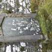
Against the inner face of the W wall there is a headstone erected in 1830 to commemorate James Campbell of Rhudle,who died in 1770 aged 67, his wife Ann MacLachlan, who died in 1784, and their son Donald Campbell of Rhudle, who died in 1804 aged 61.
RCAHMS 1992, visited April 1985
Measured Survey (16 April 1985)
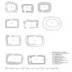
RCAHMS surveyed Kilbride Chapel on 16 April 1985 with plane-table and alidade producing a plan at a scale of 1:100 and elevations. The plan was redrawn in ink and published at a scale of 1:250 (RCAHMS 1992, 101C). The interior and exterior elevation, section and plan of the E windows were redrawn in ink and published at a scale of 1:50 (RCAHMS 1992, 102C). The plan was also included in an illustration of comparative plans of medieval churches and chapels published at a scale of 1:250 (RCAHMS 1992, 11C).


