
Following the launch of trove.scot in February 2025 we are now planning the retiral of some of our webservices. Canmore will be switched off on 24th June 2025. Information about the closure can be found on the HES website: Retiral of HES web services | Historic Environment Scotland
Carradale Point


Fort (Iron Age)
Site Name Carradale Point
Classification Fort (Iron Age)
Alternative Name(s) Kilbrannan Sound
Canmore ID 39221
Site Number NR83NW 1
NGR NR 8151 3649
Datum OSGB36 - NGR
Permalink http://canmore.org.uk/site/39221


- Council Argyll And Bute
- Parish Saddell And Skipness
- Former Region Strathclyde
- Former District Argyll And Bute
- Former County Argyll
NR83NW 1 8151 3649
(NR 8151 3646) Fort (NR)
(Vitrified) (NR)
OS 6" map, Argyllshire, 2nd ed., (1924)
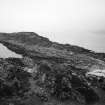
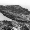
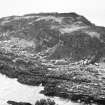
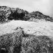
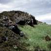
On the summit of Carradale Point, at a height of 15m OD, there is a vitrified fort measuring 56.5m by 23m internally. The site occupies the middle of an elongated peninsula which is cut off from the adjacent mainland at high tide.
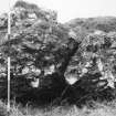
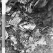
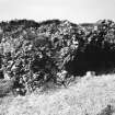
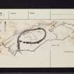
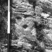
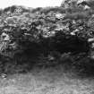
The fort defences comprise a continuous wall (A on the RCAHMS {1971} plan) with outworks (B-H) presumably designed to restrict access to the site. Wall A is now represented for the most part by a low grass-grown bank about 4.5m in thickness, from which large masses of vitrified core-material protrude as shown on the plan. A stretch of the outer face of the wall, measuring 8m in length, has survived in situ on the WNW, while, on the date of visit, it was found that the outer facing-stones at the SE angle of the fort had recently been exposed. Christison (1898) noted a considerable length of the outer face on the NW, but this is no longer visible. The masses of vitrified wall-core on the E side of the fort present a striking appearance attaining in some cases a height of 1.5m above the level of the exterior; on the SW, however, where no vitrified material is evident on the surface of the bank, six separate masses have been dislodged from the wall and lie a short distance away in the interior of the fort.
A gap in the bank between two large vitrified masses on the SE may indicate the position of the entrance. The interior contains several sinuous scarps which may be the result of surface quarrying undertaken during the construction of the fort.
Outside the fort a grass-grown stony bank (B), measuring 5.5m in thickness and 0.6m in height, runs up the slope from a rocky gully on the SE to join the fort wall a few yards S of the supposed entrance. That this bank represents a later development is suggested by the dicovery, referred to above, that the two structures are not bonded together but meet in a straight joint; the purpose of this addition was possibly to secure the entrance against attack from the S. Approach to the fort from this and other directions was likewise impeded by short lengths of walling which blocked the natural gullies leading up from the shore; these are now represented either by stretches of outer facing-stones (C, D and F) or merely by bands of rubble core (E, G and H). An oval depression, some 7.5m outside the N end of the fort, is not mentioned by Christison (1898) in his account of the site, and is probably of recent origin.
D Christison 1898; RCAHMS 1971, visited 1960.
The vitrified fort is as described and planned by RCAHMS (1971).
A small, possibly natural, penannular enclosure 4.0m internal diameter, lies just outside the south wall of the fort. It incorporates on the S side the lump of vitrifaction shown by the RCAHM, but this may be simply tumble from the fort wall.
Surveyed at 1:10 000.
Visited by OS (JB) 24 February 1978.
NR 8151 3649 Site identified as part of a coastal zone assessment survey.
M Cressey and S Badger 2005.
Field Visit (1 August 1955)
Visited by RCAHMS.
Notebook p44-48.
Publication Account (1985)
This fort occupies the highest part of a small tidal island, the southern extremity of which is Carradale Point, and access is only possible at low tide. The fort is about 56m by 23m within a thick wall, which was originally composed of stone and timber; several stretches of outer facing-stones remain on the west and south-east sides of the fort. Particularly remarkable, however, -are the massive lumps of vitrified material, the remains of the stone core of the wall fused together as a result of a great conflagration. It is possible that there was a larger number of timbers on the east side of the fort, where the vitrifaction is heaviest, for it was the burning timbers that created the draughts which allowed the fierce heat necessary for the fusing together of the stones. At one time it was thought that this was a deliberate act on the part of the prehistoric builders, but now it is generally accepted that the burning was either accidental or the result of a hostile attack.
Many of the small gullies leading to the summit of the island have been blocked by small stretches of walling in order to provide additional protection for the fort.
Information from ‘Exploring Scotland’s Heritage: Argyll and the Western Isles’, (1985).
Note (28 October 2014 - 18 October 2016)
This heavily vitrified fort is situated on the summit of Carradale Point, a narrow spit of land projecting southwards on the E side of Carradale Bay. Oval on plan, it measures 56.5m from N to S by 23m transversely (0.1ha) within a wall reduced to a bank of rubble which is up to 4.5m thick and contains large masses of vitrified wall core, particularly along its E side. A gap on the SSE is possibly an entrance, shielded on the southern side by a spur wall dropping down from the S end of the fort to the rocks on the shore, though a line of transverse face within the body of this spur possibly indicates that it is an addition. There are also other fragments of walls visible blocking gullies that would otherwise have provided access at several points on the N, W and S, effectively creating an outer fortified enclosure measuring about 140m in length from N to S by 45m in breadth (0.5ha). It is assumed that these walls are contemporary with the inner fort.
Information from An Atlas of Hillforts of Great Britain and Ireland – 18 October 2016. Atlas of Hillforts SC2452

