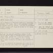
|
Prints and Drawings |
AGD 174/5 |
Records of the Society of Antiquaries of Scotland, Edinburgh, Scotland |
Plan Skene Filed SAS 465 |
|
Item Level |
|
|
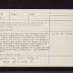
Photographs and Off-line Digital Images |
AGD 793/1 P |
Records of the Society of Antiquaries of Scotland, Edinburgh, Scotland |
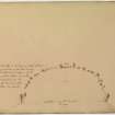
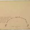
Annotated plan of stone circle from album, page 71(reverse). Photographic copy made 1977. In print room. |
1832 |
Item Level |
|
|
Prints and Drawings |
AGD 793/1 S |
Records of the Society of Antiquaries of Scotland, Edinburgh, Scotland |
Slide copy of annotated plan of stone circle from album, page 71(reverse). Copied 1977. |
1832 |
Item Level |
|
|
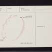
Prints and Drawings |
DC 13464 |
Records of the Royal Commission on the Ancient and Historical Monuments of Scotland (RCAHMS), Edinbu |
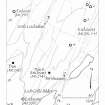
Plane-table survey; enclosure, Loch Coille-Bharr. |
6/5/1982 |
Item Level |
|
|
Photographs and Off-line Digital Images |
DC 13465 P |
Records of the Royal Commission on the Ancient and Historical Monuments of Scotland (RCAHMS), Edinbu |
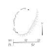
Publication drawing: enclosure, Loch Coille-Bharr.
Photographic copy. |
c. 1982 |
Item Level |
|
|
Photographs and Off-line Digital Images |
DC 13465 S |
Records of the Royal Commission on the Ancient and Historical Monuments of Scotland (RCAHMS), Edinbu |
Publication drawing: enclosure, Loch Coille-Bharr.
Photographic copy. |
1982 |
Item Level |
|
|
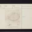
Prints and Drawings |
DC 4372 |
Papers of Professor Alexander Thom, engineer and archaeologist, Dunlop, East Ayrshire, Scotland |
Plan of enclosure.Annotated. |
|
Item Level |
|
|
Photographs and Off-line Digital Images |
DC 13454 P |
Records of the Royal Commission on the Ancient and Historical Monuments of Scotland (RCAHMS), Edinbu |
Publication Drawing; Enclosures, Barnluasgan location map.
Photographic Copy |
5/11/1986 |
Item Level |
|
|
Manuscripts |
MS 430/107 |
Papers of Professor Alexander Thom, engineer and archaeologist, Dunlop, East Ayrshire, Scotland |
Thom card index. |
|
Item Level |
|
 |
On-line Digital Images |
SC 730436 |
Records of the Society of Antiquaries of Scotland, Edinburgh, Scotland |
Annotated plan of stone circle from album, page 71(reverse). Digital image of AGD/793/1/P. |
1832 |
Item Level |
|
|
Manuscripts |
MS 2561 |
|
Report of a community archaeology project at Barnluasgan dun and enclosure. |
11/2005 |
Item Level |
|
|
Manuscripts |
MS 430 |
Papers of Professor Alexander Thom, engineer and archaeologist, Dunlop, East Ayrshire, Scotland |
Collection of notebooks (99 in total). |
|
Item Level |
|
|
Prints and Drawings |
DC 13465 |
Records of the Royal Commission on the Ancient and Historical Monuments of Scotland (RCAHMS), Edinbu |
Publication drawing: enclosure, Loch Coille-Bharr.
|
c. 1982 |
Item Level |
|
|
Prints and Drawings |
DC 13454 |
Records of the Royal Commission on the Ancient and Historical Monuments of Scotland (RCAHMS), Edinbu |
Publication Drawing; Enclosures, Barnluasgan location map.
|
5/11/1986 |
Item Level |
|
 |
On-line Digital Images |
SC 1427342 |
Records of the Royal Commission on the Ancient and Historical Monuments of Scotland (RCAHMS), Edinbu |
Publication Drawing; Enclosures, Barnluasgan location map.
Photographic Copy |
5/11/1986 |
Item Level |
|
 |
On-line Digital Images |
SC 1427347 |
Records of the Royal Commission on the Ancient and Historical Monuments of Scotland (RCAHMS), Edinbu |
Publication drawing: enclosure, Loch Coille-Bharr.
Photographic copy. |
c. 1982 |
Item Level |
|
 |
On-line Digital Images |
DP 353462 |
Records of the Society of Antiquaries of Scotland, Edinburgh, Scotland |
Annotated plan of stone circle from album, page 71(reverse). |
1832 |
Item Level |
|
 |
On-line Digital Images |
SC 2417430 |
Records of the Ordnance Survey, Southampton, Hampshire, England |
Kilmory Oib, NR79SE 19, Ordnance Survey index card, page number 1, Recto |
c. 1958 |
Item Level |
|
 |
On-line Digital Images |
SC 2417431 |
Records of the Ordnance Survey, Southampton, Hampshire, England |
Kilmory Oib, NR79SE 19, Ordnance Survey index card, page number 2, Recto |
c. 1958 |
Item Level |
|
 |
On-line Digital Images |
SC 2417432 |
Records of the Ordnance Survey, Southampton, Hampshire, England |
Kilmory Oib, NR79SE 19, Ordnance Survey index card, page number 2, Recto |
c. 1958 |
Item Level |
|
 |
On-line Digital Images |
SC 2417433 |
Records of the Ordnance Survey, Southampton, Hampshire, England |
Kilmory Oib, NR79SE 19, Ordnance Survey index card, page number 1, Recto |
c. 1958 |
Item Level |
|
 |
On-line Digital Images |
SC 2417434 |
Records of the Ordnance Survey, Southampton, Hampshire, England |
Kilmory Oib, NR79SE 19, Ordnance Survey index card, Recto |
c. 1958 |
Item Level |
|
 |
On-line Digital Images |
SC 2417435 |
Records of the Ordnance Survey, Southampton, Hampshire, England |
Kilmory Oib, NR79SE 19, Ordnance Survey index card, Recto |
c. 1958 |
Item Level |
|
|
All Other |
551 166/1/1 |
Records of the Ordnance Survey, Southampton, Hampshire, England |
Archaeological site card index ('495' cards) |
1947 |
Sub-Group Level |
|


