
Kilmory Oib


Enclosure (Period Unassigned)
Site Name Kilmory Oib
Classification Enclosure (Period Unassigned)
Alternative Name(s) Loch Coille-bharr; Knapdale
Canmore ID 39170
Site Number NR79SE 19
NGR NR 7828 9070
Datum OSGB36 - NGR
Permalink http://canmore.org.uk/site/39170


- Council Argyll And Bute
- Parish North Knapdale
- Former Region Strathclyde
- Former District Argyll And Bute
- Former County Argyll
NR79SE 19 7828 9070.
(NR 7828 9070) Circle (NR)
OS 6" map, Argyllshire, 2nd ed., (1924)
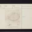
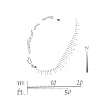
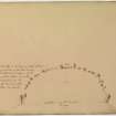
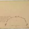
Situated in a clearing in Forestry Commission plantings, an oval terrace, 65' x 42', the E side probably scarped and W side against the hill behind, outlined by boulders on the W with erect stones c.4' high at NE and SW. No trace of stones along E side.
D Christison 1904; M Campbell and M Sandeman 1964.
At this site ar two upright earthfast stones 22.0m apart at the NE and SW ends of the elliptical levelled top of a small spur. Around the W side are several stones at least one of which appears to be a fallen upright. The E side is devoid of stones and consists of a grassy slope. Although it is not possible to classify this site it is clear that the levelled area could not have supported a stone circle 22.0m in diameter and the total absence of stone in the centre rules out the possibility of it having been a cairn.
Surveyed at 1:10 000.
Visited by OS (JP) 21 June 1973.
This site lies at the foot of a steep E-facing slope and is generally as described in the previous information. The two upright stone slabs (1.2m high and 0.6m wide) are 'linked' on the west by a random spread of earthfast boulders which do not appear to be the remains of walling or of any structure. The artificial slopes forming the E side of the sub-oval area are up to 1.5m high. The position of the feature suggests that it may have been an enclosure rather than a ritual site. (c/f homesteads- NM91SE 6 and NM91SE 8. )
Surveyed at 1/10,000.
Visited by OS (TRG) 11 February 1977.
Field Visit (May 1982)
This enclosure situated on the W side of the road between Bellanoch and Tayvallich and 230m NW of Loch Coille-Bharr, has sometimes been described as a stone circle because of the presence of two unusually large upright stones (Campbell and Sandeman 1964). D-shaped on plan, the enclosure measures about 20m by 12m, with a natural scarp forming the chord on the E, and the W side now represented by an arc of massive boulders. The large upright stones are situated at either end of the arc; the northernmost, now sloping to the NE, measuring 0.5mm by 0.25m at the base and rising with straight sides to a height of 1.2m, the southernmost measuring 0.75m by 0.35m at the base and 1.4m in height.
RCAHMS 1988, visited May 1982.
Watching Brief (May 2001 - September 2001)
NR 783 907 A watching brief was carried out between May and September 2000 on a water pipeline along the roadside near an enclosure of uncertain date and function (NMRS NR 79 SE 19). No finds of archaeological significance were made.
Report to be lodged with the NMRS.
Sponsor: West of Scotland Water.
G Mudie 2001m
Publication Account (2009)
The website text produced for Kilmory Oib webpages on the Forest Heritage Scotland website (www.forestheritagescotland.com).
Introduction: The stone, the well and the settlement
In Knapdale Forest, near the edge of Loch Coille Bharr, you can discover the remains of the township called Kilmory Oib.
Usually referred to simply as Kilmory, the township is part of the estate known as Oib, or Oab, meaning bay or inlet in Gaelic. The lands of Kilmory belonged to the Campbells, but in 1785 a bankrupt Neil Campbell sold them to Neil Malcolm of Poltalloch.
The township consists of at least seventeen buildings, including houses and byres for the animals. There are also two sub-circular piles of rubble, which may be the remains of corn drying kilns.
There is also an early Christian cross-marked stone, which stands beside a small well. It is thought that the stone dates to the 8th or 9th century.
Historical records mention Kilmory from around the 17th century. One of the earliest known references is in the 1694 Hearth Tax. It records tenants Alexander and Malcolm McIlvernock, Robert Campbell and Donald McMillan as having paid their taxes.
One of the last references is on another tax list, the 1843 Road Money tax, which lists Angus and Archibald McDugall, Neil McCalum and John Gillies as tenants.
It is unknown exactly when and how Kilmory was abandoned but the buildings are shown as unroofed by 1873 when the 1st edition Ordnance Survey map was published.
Read our "People" story to find out more about what could have happened.
People Story: Aiding and abetting
Kilmory Oib has family connections to the nearby township of Arichonan, where the tenants rioted against eviction in 1848.
At the beginning of the 18th century, Neil Malcolm of Poltalloch bought the lands of both Arichonan and Kilmory Oib among others. In 1848, Malcolm ordered the eviction of his tenants at Arichonan. You can discover more about this on our Arichonan pages.
The tenants did not go quietly and a riot began. Historical records show that those involved were not limited to the tenants of Arichonan. Amongst the rioters were two McMillan brothers from Kilmory, sons of one of the evictees, Neil McMillan. Although arrested, the brothers escaped punishment. Their younger brother, Neil McMillan Junior from Cairnbaan, was not so lucky, however, and served an eight month jail sentence. Another Kilmory rioter, John Gillies, escaped the law and disappeared.
The Kilmory Oib tenants probably fought not only for family and for friends but because they feared their own homes were in danger of the same threat.
The purpose of the Arichonan evictions was to clear the land for sheep farming. Today, if you explore Kilmory, you can discover evidence that supports the later use of this site for sheep farming. This evidence is similar to that found at Arichonan, for example some buildings have been partly demolished; the walls left form enclosures that are ideal for keeping sheep.

