
Following the launch of trove.scot in February 2025 we are now planning the retiral of some of our webservices. Canmore will be switched off on 24th June 2025. Information about the closure can be found on the HES website: Retiral of HES web services | Historic Environment Scotland
Druim An Duin


Galleried Dun (Prehistoric)
Site Name Druim An Duin
Classification Galleried Dun (Prehistoric)
Canmore ID 39160
Site Number NR79SE 1
NGR NR 7811 9130
Datum OSGB36 - NGR
Permalink http://canmore.org.uk/site/39160


First 100 images shown. See the Collections panel (below) for a link to all digital images.
- Council Argyll And Bute
- Parish North Knapdale
- Former Region Strathclyde
- Former District Argyll And Bute
- Former County Argyll
NR79SE 1 7811 9130.
(NR 7811 9130) Fort (NR) (Remains of)
OS 6" map, Argyllshire, 2nd ed., (1900)
A dun occupies the summit of Druim an Duin. It measures 50' x 30' within a wall whose thickness varies considerably from a maximum of 17' on the S. The existing remains appear to end on the brink of the precipitous NW flank of the ridge, but the question whether the two ends were once linked by a full-sized wall, or a lesser wall, or none at all, can only be resolved by excavation. On the N and NE, the wall appears to stand on a stone-built platform which could have been reconstructed to form a level foundation, but again only excavation can determine the nature of the platform and its relationship to the wall. Christison (1904) states that the remains of a secondry wall exist about 6' within the N wall and adds that the inner face on the E has a 'scarcement' 5' high and 1 1/2' wide.
Both entrances have door-checks, while the S entrance also has a bar-hole at least 10' long, close to the W door-check.
A small passage, 3' wide by 4' in height and length, with its lintels still in place, opens halfway along the E wall of the S entrance. The N wall of the gallery can be traced for a further 11', parallel to, and 8' from the inner face of the dun wall, before it is obscured by debris, though several long slabs, possibly lintels, lie half buried in debris for another 11'. The S gallery wall turns sharply S for 5' at the end of the small passage, and then ENE for 8', forming a small bay before continuing.
Two terraces of stones lying just outside the N entrance are probably dumps from excavations in 1904. Relics found then included a steatite cup, part of a rotary quern-stone, and a perforated sandstone disc, 3 3/4" in diameter.
D Christison 1905; Information from RCAHMS manuscript, visited 1958.
Generally as described by RCAHMS. There is no evidence of a scarcement within the dun. The N entrance, exposed in 1904, would appear to have been blocked by a secondary wall.
A terrace with stones outside the S entrance is probably an excavation dump, as the illustration would tend to confirm.
Surveyed at 1:10,000.
Visited by OS (DWR) 22 May 1973.
No change to the report of 22 May 1973.
Surveyed at 1/10,000.
Visited by OS (TRG) 26 January 1977.
Measured Survey (20 March 1958)
Surveyed by RCAHMS, as part of Marginal Land Project.
Field Visit (June 1979)
Re-surveyed, photographed and described by RCAHMS.
Published in Argyll Volume 6 (1988).
Measured Survey (June 1979)
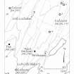
RCAHMS surveyed Druim an Duin dun on June 1979 with plane-table and alidade producing a plan at a scale of 1:100. The plan of the dun was redrawn in ink and published at a scale of 1:250 (RCAHMS 1988a, 180).
Field Visit (June 1979)
This well-preserved dun occupies a commanding position at the N end of a ridge which overlooks a sharp bend in the public road (B8025) that runs from the head of Caol Scotnish to Bellanoch (Campbell and Sandeman 1964). The site is easily approached from the SW along the spine of the ridge, but on the NE and SE it is flanked by long, steep slopes and on the NW by a precipitous cliff some 30m in height. The dun was excavated on behalf of the Society of Antiquaries of Scotland in 1904-5, but the work appears to have consisted of little more than stone clearance (Christison 1905).
Roughly oval on plan, the dun measures 14.4m by 9.5m within a massive wall which ranges from 5.2m in thickness on the SW to as little as 1m above the cliff on the NW. The wall is best preserved on the S, where it still stands to a height of 1.7m in twelve courses. Here, to the E and W of the entrance-passage, there are the remains of a scarcement-like ledge 1.7m above the present level of the ground. On the W the ledge is 0.4m wide, but to the E of the entrance it increases to 0.9m, which is rather greater than usual for a true scarcement, and it may indicate an internal reduction in the wall thickness rather than the presence of a floor- or roof-line. There is a curious jointing of the inner wall-face opposite the E end of this feature and it may be more than a coincidence that the shelf-scarcement observed in 1904-5 on the E side of the dun also terminates at this point. The second scarcement consists of a series of crude corbels projecting about 0.3m from the inner face at an average height of 0.6 m above the present level of the adjacent portion of the interior. The excavation report, however, states that the scarcement here was '5 feet (1.5m) high and 1 ? (0.45m) wide', and it is not immediately clear how this disparity with the surviving remains can be accounted for. While it is conceivable that the dimensions of the shelf on the E could have been confused with those of the ledge on the S, the published account indicates that the latter, although sought by the excavators, was not in fact recognised. It is even possible that the portion of the E wall incorporating an upper scarcement has collapsed or been destroyed at some time after the excavation, but this would not explain why the lower feature, which shows clearly in one of the photographs illustrating the report, was not also mentioned. It seems likely, therefore, that during excavation the interior on this side was cleared of debris to a much lower level than is now apparent - a probability that the photograph in question also appears to confirm - and at its lowest point about 1.5m of inner wall-face extended below the scarcement. The abrupt fall of ground that this implies would also indicate that the purpose of the feature in question was to support one side of a horizontal wooden flooring, without which occupation of the steeply sloping interior would have presented considerable difficulties.
There are two entrances to the dun, both opening on to the crest of the ridge; the S passage probably provided the principal access to the dun, while the N entrance served as a postern. The S entrance, which is particularly well preserved, leads at a slightly oblique angle through the thickest section of the wall and measures 1.2m in width at the exterior, 1.8m at the inner end, and has opposed door-checks 1.8m from the outside. The jambs are formed of single upright slabs, up to 1.5m high, and to the N of the W check there is a bar-hole at least 2m deep. Until the late 19th century at least one of the lintel stones covering the passage remained in situ and others lay dislodged in the rubble;3 none of these survives, but part of the passage still stands to lintel height. Opening from the SE side of the entrance inside the checks there is a mural or guard chamber, entered through a narrow passage, 1.2 m high, which still retains its partly corbelled and lintelled roof. The chamber extends to the E as an intramural gallery, but this eastward extension may have served only a structural purpose.
The NE entrance-passage is 0.9m wide at the outer end, l.8m at the inner, and has been checked for a door; it is less well preserved than the SW entrance, and the side-walls stand no more than l.1m high in six courses. A large slab projecting into the E side of the passage is probably a foundation stone which has slipped out of position.
The only internal feature recognised by the excavators of 1904-5 was the arc of secondary walling that effectively blocks the N entrance. Without excavation it is impossible to determine whether it represents relatively modern handling of the site or a refurbishment of the dun structure in antiquity; the robustness of the walling and the character of its junction with the inner face of the E side of the dun makes the second interpretation more attractive.
The presence of considerable quantities of tumbled debris to the N and S of the dun, much of it evidently relocated during the 1904-5 excavations, makes it difficult to be certain if there were ever outlying works of any description or date. The area of hatching shown on the excavation plan as apparently springing from the dun wall on the SW may conceivably indicate the truncated remains of such a feature, but no traces of this can now be seen on the ground, and the irregularly disposed slabs and scattered debris that fringe the sloping shelf on this side are best explained as either the results of stone clearance during excavation or possibly the collapsed elements of a relatively recent dyke. The more obviously defined areas to the N seem largely to represent the excavators' stone-heaps, revetted in such a way as to provide convenient access to the summit.
The small finds recovered during excavation comprised a handled steatite 'cup', the upper half of a rotary quern, another quern-stone and several other stone objects; they are now in the Royal Museum of Scotland, Edinburgh.
Visited June 1979
RCAHMS 1988
Ground Survey (24 October 2011 - 26 October 2011)
A topographic and laser scan survey of Druim an Duin was undertaken 24–26 October 2011. A series of plans and elevations were produced of the site which is generally in good condition.
Archive: RCAHMS (intended)
Funder: Forestry Commission Scotland
AOC Archaeology Group 2011
Field Visit (24 October 2012 - 25 October 2012)
NR 8043 6407 and NR 7811 9130 A survey was carried out 24–25 October 2012 on two duns in Argyll. Detailed plans and elevations were produced and laser scanning was used to produce 3D models of the sites.
Archive: RCAHMS
Funder: Forestry Commission Scotland
Graeme Cavers, AOC Archaeology Group
2012

