
Ground Survey


Date 24 October 2011 - 26 October 2011
Event ID 963281
Category Recording
Type Ground Survey
Permalink http://canmore.org.uk/event/963281
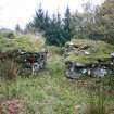
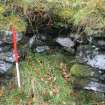
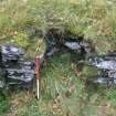
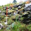
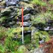
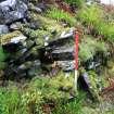
A topographic and laser scan survey of Druim an Duin was undertaken 24–26 October 2011. A series of plans and elevations were produced of the site which is generally in good condition.
Archive: RCAHMS (intended)
Funder: Forestry Commission Scotland
AOC Archaeology Group 2011
Ordnance Survey licence number AC0000807262. All rights reserved.
Canmore Disclaimer.
© Bluesky International Limited 2025.
|
Druim An Duin
Galleried Dun (Prehistoric)
Canmore ID 39160 |
|

DP 254260
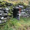
General view of the S entrance to Druim an Duin, facing north
Records of AOC Archaeology Group, archaeologists, Loanhead, Midlothian, Scotland
24/10/2011
© Copyright: AOC Archaeology Group. Courtesy of HES.

DP 254261
General view of the S entrance to Druim an Duin, facing north
Records of AOC Archaeology Group, archaeologists, Loanhead, Midlothian, Scotland
24/10/2011
© Copyright: AOC Archaeology Group. Courtesy of HES.

DP 254262
General view of the S entrance to Druim an Duin, facing NE
Records of AOC Archaeology Group, archaeologists, Loanhead, Midlothian, Scotland
24/10/2011
© Copyright: AOC Archaeology Group. Courtesy of HES.

DP 254263
General view of the S entrance to Druim an Duin, facing NE
Records of AOC Archaeology Group, archaeologists, Loanhead, Midlothian, Scotland
24/10/2011
© Copyright: AOC Archaeology Group. Courtesy of HES.

DP 254264
General view of the S entrance to Druim an Duin, facing north
Records of AOC Archaeology Group, archaeologists, Loanhead, Midlothian, Scotland
24/10/2011
© Copyright: AOC Archaeology Group. Courtesy of HES.

DP 254265
General view of the S entrance to Druim an Duin, facing north
Records of AOC Archaeology Group, archaeologists, Loanhead, Midlothian, Scotland
24/10/2011
© Copyright: AOC Archaeology Group. Courtesy of HES.

DP 254266
General view of the S entrance to Druim an Duin, facing NW
Records of AOC Archaeology Group, archaeologists, Loanhead, Midlothian, Scotland
24/10/2011
© Copyright: AOC Archaeology Group. Courtesy of HES.

DP 254267
General view of the S entrance to Druim an Duin, facing NW
Records of AOC Archaeology Group, archaeologists, Loanhead, Midlothian, Scotland
24/10/2011
© Copyright: AOC Archaeology Group. Courtesy of HES.

DP 254268
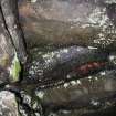
Detail of bar hole
Records of AOC Archaeology Group, archaeologists, Loanhead, Midlothian, Scotland
24/10/2011
© Copyright: AOC Archaeology Group. Courtesy of HES.

DP 254269
Detail of bar hole
Records of AOC Archaeology Group, archaeologists, Loanhead, Midlothian, Scotland
24/10/2011
© Copyright: AOC Archaeology Group. Courtesy of HES.

DP 254270
Detail of bar hole
Records of AOC Archaeology Group, archaeologists, Loanhead, Midlothian, Scotland
24/10/2011
© Copyright: AOC Archaeology Group. Courtesy of HES.

DP 254271
Bar hole in SE-facing elevation of entrance, behind door jamb
Records of AOC Archaeology Group, archaeologists, Loanhead, Midlothian, Scotland
24/10/2011
© Copyright: AOC Archaeology Group. Courtesy of HES.

DP 254272
Bar hole in SE-facing elevation of entrance, behind door jamb
Records of AOC Archaeology Group, archaeologists, Loanhead, Midlothian, Scotland
24/10/2011
© Copyright: AOC Archaeology Group. Courtesy of HES.

DP 254273
S entrance to Druim an Duin, SE-facing elevation (point 1), from the N
Records of AOC Archaeology Group, archaeologists, Loanhead, Midlothian, Scotland
24/10/2011
© Copyright: AOC Archaeology Group. Courtesy of HES.

DP 254274
S entrance to Druim an Duin, SE-facing elevation (point 1), from the N
Records of AOC Archaeology Group, archaeologists, Loanhead, Midlothian, Scotland
24/10/2011
© Copyright: AOC Archaeology Group. Courtesy of HES.

DP 254275
Detail of the collapsed cell in the SE-facing elevation, S entrance
Records of AOC Archaeology Group, archaeologists, Loanhead, Midlothian, Scotland
24/10/2011
© Copyright: AOC Archaeology Group. Courtesy of HES.

DP 254276
S entrance to Druim an Duin, SE-facing elevation, from the N
Records of AOC Archaeology Group, archaeologists, Loanhead, Midlothian, Scotland
24/10/2011
© Copyright: AOC Archaeology Group. Courtesy of HES.

DP 254277
Internal wall face at point 3, from N
Records of AOC Archaeology Group, archaeologists, Loanhead, Midlothian, Scotland
24/10/2011
© Copyright: AOC Archaeology Group. Courtesy of HES.

DP 254278
Internal wall face at point 3, from N
Records of AOC Archaeology Group, archaeologists, Loanhead, Midlothian, Scotland
24/10/2011
© Copyright: AOC Archaeology Group. Courtesy of HES.

DP 254279
S entrance to Drum an Duin, NW-facing elevation, facing N
Records of AOC Archaeology Group, archaeologists, Loanhead, Midlothian, Scotland
24/10/2011
© Copyright: AOC Archaeology Group. Courtesy of HES.

DP 254280
S entrance to Drum an Duin, NW-facing elevation
Records of AOC Archaeology Group, archaeologists, Loanhead, Midlothian, Scotland
24/10/2011
© Copyright: AOC Archaeology Group. Courtesy of HES.

DP 254281
S entrance to Drum an Duin, NW-facing elevation
Records of AOC Archaeology Group, archaeologists, Loanhead, Midlothian, Scotland
24/10/2011
© Copyright: AOC Archaeology Group. Courtesy of HES.

DP 254282
S entrance to Drum an Duin, NW-facing elevation
Records of AOC Archaeology Group, archaeologists, Loanhead, Midlothian, Scotland
24/10/2011
© Copyright: AOC Archaeology Group. Courtesy of HES.

DP 254283
West side of N entrance to Drum an Duin, facing south
Records of AOC Archaeology Group, archaeologists, Loanhead, Midlothian, Scotland
24/10/2011
© Copyright: AOC Archaeology Group. Courtesy of HES.

DP 254284
West side of N entrance to Drum an Duin, facing southeast
Records of AOC Archaeology Group, archaeologists, Loanhead, Midlothian, Scotland
24/10/2011
© Copyright: AOC Archaeology Group. Courtesy of HES.

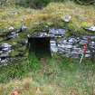
DP 254285
Entrance to guard cell in NW-facing elevation of S entrance
Records of AOC Archaeology Group, archaeologists, Loanhead, Midlothian, Scotland
24/10/2011
© Copyright: AOC Archaeology Group. Courtesy of HES.

DP 254286
Entrance to guard cell in NW-facing elevation of S entrance
Records of AOC Archaeology Group, archaeologists, Loanhead, Midlothian, Scotland
24/10/2011
© Copyright: AOC Archaeology Group. Courtesy of HES.

DP 254287
Entrance to guard cell in NW-facing elevation of S entrance
Records of AOC Archaeology Group, archaeologists, Loanhead, Midlothian, Scotland
24/10/2011
© Copyright: AOC Archaeology Group. Courtesy of HES.

DP 254288
Entrance to guard cell in NW-facing elevation of S entrance
Records of AOC Archaeology Group, archaeologists, Loanhead, Midlothian, Scotland
24/10/2011
© Copyright: AOC Archaeology Group. Courtesy of HES.

DP 254289
Internal wall to the east of the S entrance
Records of AOC Archaeology Group, archaeologists, Loanhead, Midlothian, Scotland
24/10/2011
© Copyright: AOC Archaeology Group. Courtesy of HES.

DP 254290
Internal wall to the east of the S entrance
Records of AOC Archaeology Group, archaeologists, Loanhead, Midlothian, Scotland
24/10/2011
© Copyright: AOC Archaeology Group. Courtesy of HES.

DP 254291
Internal wall to the east of the S entrance
Records of AOC Archaeology Group, archaeologists, Loanhead, Midlothian, Scotland
24/10/2011
© Copyright: AOC Archaeology Group. Courtesy of HES.

DP 254292
Internal wall to the west of the S entrance
Records of AOC Archaeology Group, archaeologists, Loanhead, Midlothian, Scotland
24/10/2011
© Copyright: AOC Archaeology Group. Courtesy of HES.

DP 254293
Internal wall to the west of the S entrance
Records of AOC Archaeology Group, archaeologists, Loanhead, Midlothian, Scotland
24/10/2011
© Copyright: AOC Archaeology Group. Courtesy of HES.

DP 254294
Internal wall to the west of the S entrance
Records of AOC Archaeology Group, archaeologists, Loanhead, Midlothian, Scotland
24/10/2011
© Copyright: AOC Archaeology Group. Courtesy of HES.

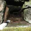
DP 254295
Inside of the guard cell entrance, facing SE
Records of AOC Archaeology Group, archaeologists, Loanhead, Midlothian, Scotland
24/10/2011
© Copyright: AOC Archaeology Group. Courtesy of HES.

DP 254296
Inside of the guard cell entrance, facing SE
Records of AOC Archaeology Group, archaeologists, Loanhead, Midlothian, Scotland
24/10/2011
© Copyright: AOC Archaeology Group. Courtesy of HES.

DP 254297
Inside of the guard cell entrance, facing upwards, showing lintel stones
Records of AOC Archaeology Group, archaeologists, Loanhead, Midlothian, Scotland
24/10/2011
© Copyright: AOC Archaeology Group. Courtesy of HES.

DP 254298
Entrance to the guard cell, facing SE
Records of AOC Archaeology Group, archaeologists, Loanhead, Midlothian, Scotland
24/10/2011
© Copyright: AOC Archaeology Group. Courtesy of HES.

DP 254299
View of the N end of the Dun facing N
Records of AOC Archaeology Group, archaeologists, Loanhead, Midlothian, Scotland
24/10/2011
© Copyright: AOC Archaeology Group. Courtesy of HES.

DP 254300
View of the N end of the Dun facing N
Records of AOC Archaeology Group, archaeologists, Loanhead, Midlothian, Scotland
24/10/2011
© Copyright: AOC Archaeology Group. Courtesy of HES.

DP 254301
View of the N end of the Dun facing N
Records of AOC Archaeology Group, archaeologists, Loanhead, Midlothian, Scotland
24/10/2011
© Copyright: AOC Archaeology Group. Courtesy of HES.

DP 254302
S Entrance to Druim an Duin
Records of AOC Archaeology Group, archaeologists, Loanhead, Midlothian, Scotland
24/10/2011
© Copyright: AOC Archaeology Group. Courtesy of HES.

DP 254303
S Entrance to Druim an Duin
Records of AOC Archaeology Group, archaeologists, Loanhead, Midlothian, Scotland
24/10/2011
© Copyright: AOC Archaeology Group. Courtesy of HES.

DP 254304
S Entrance to Druim an Duin
Records of AOC Archaeology Group, archaeologists, Loanhead, Midlothian, Scotland
24/10/2011
© Copyright: AOC Archaeology Group. Courtesy of HES.

DP 254305
S Entrance to Druim an Duin
Records of AOC Archaeology Group, archaeologists, Loanhead, Midlothian, Scotland
24/10/2011
© Copyright: AOC Archaeology Group. Courtesy of HES.

DP 254306
S Entrance to Druim an Duin
Records of AOC Archaeology Group, archaeologists, Loanhead, Midlothian, Scotland
24/10/2011
© Copyright: AOC Archaeology Group. Courtesy of HES.

DP 254307
S Entrance to Druim an Duin
Records of AOC Archaeology Group, archaeologists, Loanhead, Midlothian, Scotland
24/10/2011
© Copyright: AOC Archaeology Group. Courtesy of HES.

DP 254308
Detail of the collapsed cell in the SE-facing elevation, S entrance
Records of AOC Archaeology Group, archaeologists, Loanhead, Midlothian, Scotland
24/10/2011
© Copyright: AOC Archaeology Group. Courtesy of HES.

DP 254309
Detail of the collapsed cell in the SE-facing elevation, S entrance
Records of AOC Archaeology Group, archaeologists, Loanhead, Midlothian, Scotland
24/10/2011
© Copyright: AOC Archaeology Group. Courtesy of HES.

DP 254310
Detail of the collapsed cell in the SE-facing elevation, S entrance
Records of AOC Archaeology Group, archaeologists, Loanhead, Midlothian, Scotland
24/10/2011
© Copyright: AOC Archaeology Group. Courtesy of HES.

DP 254311
S entrance to Druim an Duin, SE-facing elevation (point 1), from the N
Records of AOC Archaeology Group, archaeologists, Loanhead, Midlothian, Scotland
24/10/2011
© Copyright: AOC Archaeology Group. Courtesy of HES.

DP 254312
View of the N entrance at point 4 with secondary walling blocking the passageway
Records of AOC Archaeology Group, archaeologists, Loanhead, Midlothian, Scotland
24/10/2011
© Copyright: AOC Archaeology Group. Courtesy of HES.

DP 254313
View of the N entrance at point 4 with secondary walling blocking the passageway
Records of AOC Archaeology Group, archaeologists, Loanhead, Midlothian, Scotland
24/10/2011
© Copyright: AOC Archaeology Group. Courtesy of HES.

DP 254314
View of the N entrance at point 4 with secondary walling blocking the passageway
Records of AOC Archaeology Group, archaeologists, Loanhead, Midlothian, Scotland
24/10/2011
© Copyright: AOC Archaeology Group. Courtesy of HES.

DP 254315
View of the interior wall to the east the N entrance, facing N
Records of AOC Archaeology Group, archaeologists, Loanhead, Midlothian, Scotland
24/10/2011
© Copyright: AOC Archaeology Group. Courtesy of HES.

DP 254316
View of the interior wall to the east the N entrance, facing N
Records of AOC Archaeology Group, archaeologists, Loanhead, Midlothian, Scotland
24/10/2011
© Copyright: AOC Archaeology Group. Courtesy of HES.

DP 254317
View of the interior wall to the east the N entrance, facing N
Records of AOC Archaeology Group, archaeologists, Loanhead, Midlothian, Scotland
24/10/2011
© Copyright: AOC Archaeology Group. Courtesy of HES.

DP 254318
View of the east side of N entrance, facing NE
Records of AOC Archaeology Group, archaeologists, Loanhead, Midlothian, Scotland
24/10/2011
© Copyright: AOC Archaeology Group. Courtesy of HES.

DP 254319
View of remaining wall at Druim an Duin
Records of AOC Archaeology Group, archaeologists, Loanhead, Midlothian, Scotland
24/10/2011
© Copyright: AOC Archaeology Group. Courtesy of HES.

DP 254320
View of remaining wall at Druim an Duin
Records of AOC Archaeology Group, archaeologists, Loanhead, Midlothian, Scotland
24/10/2011
© Copyright: AOC Archaeology Group. Courtesy of HES.

DP 254321
View of remaining wall at Druim an Duin
Records of AOC Archaeology Group, archaeologists, Loanhead, Midlothian, Scotland
24/10/2011
© Copyright: AOC Archaeology Group. Courtesy of HES.

DP 254322
View of the interior of the site, facing S
Records of AOC Archaeology Group, archaeologists, Loanhead, Midlothian, Scotland
24/10/2011
© Copyright: AOC Archaeology Group. Courtesy of HES.

DP 254323
View of the interior of the site, facing S
Records of AOC Archaeology Group, archaeologists, Loanhead, Midlothian, Scotland
24/10/2011
© Copyright: AOC Archaeology Group. Courtesy of HES.

DP 254324
View of the interior of the site, facing S
Records of AOC Archaeology Group, archaeologists, Loanhead, Midlothian, Scotland
24/10/2011
© Copyright: AOC Archaeology Group. Courtesy of HES.

DP 254325
View of the interior of the site, facing S
Records of AOC Archaeology Group, archaeologists, Loanhead, Midlothian, Scotland
24/10/2011
© Copyright: AOC Archaeology Group. Courtesy of HES.

DP 254326
View of the interior of the site, facing S
Records of AOC Archaeology Group, archaeologists, Loanhead, Midlothian, Scotland
24/10/2011
© Copyright: AOC Archaeology Group. Courtesy of HES.

DP 254327
View of the W facing elevation (point 5) of the N entrance
Records of AOC Archaeology Group, archaeologists, Loanhead, Midlothian, Scotland
24/10/2011
© Copyright: AOC Archaeology Group. Courtesy of HES.

DP 254328
View of the W facing elevation (point 5) of the N entrance
Records of AOC Archaeology Group, archaeologists, Loanhead, Midlothian, Scotland
24/10/2011
© Copyright: AOC Archaeology Group. Courtesy of HES.

DP 254329
View of the exterior wall face (point 5) to NE of N entrance
Records of AOC Archaeology Group, archaeologists, Loanhead, Midlothian, Scotland
24/10/2011
© Copyright: AOC Archaeology Group. Courtesy of HES.

DP 254330
View of the exterior wall face (point 5) to NE of N entrance
Records of AOC Archaeology Group, archaeologists, Loanhead, Midlothian, Scotland
24/10/2011
© Copyright: AOC Archaeology Group. Courtesy of HES.

DP 254331
View of the exterior wall face (point 5) to NE of N entrance
Records of AOC Archaeology Group, archaeologists, Loanhead, Midlothian, Scotland
24/10/2011
© Copyright: AOC Archaeology Group. Courtesy of HES.

DP 254332
View of the exterior wall face (point 5) to NE of N entrance
Records of AOC Archaeology Group, archaeologists, Loanhead, Midlothian, Scotland
24/10/2011
© Copyright: AOC Archaeology Group. Courtesy of HES.

DP 254333
View of the exterior wall face (point 5) to NE of N entrance
Records of AOC Archaeology Group, archaeologists, Loanhead, Midlothian, Scotland
24/10/2011
© Copyright: AOC Archaeology Group. Courtesy of HES.

DP 254334
Fragment of surviving wall face at point 6, facing W
Records of AOC Archaeology Group, archaeologists, Loanhead, Midlothian, Scotland
24/10/2011
© Copyright: AOC Archaeology Group. Courtesy of HES.

DP 254335
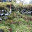
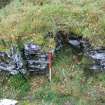
Extent of rubble to the east of the site
Records of AOC Archaeology Group, archaeologists, Loanhead, Midlothian, Scotland
24/10/2011
© Copyright: AOC Archaeology Group. Courtesy of HES.

DP 254336
Extent of rubble to the east of the site
Records of AOC Archaeology Group, archaeologists, Loanhead, Midlothian, Scotland
24/10/2011
© Copyright: AOC Archaeology Group. Courtesy of HES.

DP 254337
Fragment of surviving wall face at point 6, facing W
Records of AOC Archaeology Group, archaeologists, Loanhead, Midlothian, Scotland
24/10/2011
© Copyright: AOC Archaeology Group. Courtesy of HES.

DP 254338
Fragment of surviving wall face at point 6, facing W
Records of AOC Archaeology Group, archaeologists, Loanhead, Midlothian, Scotland
24/10/2011
© Copyright: AOC Archaeology Group. Courtesy of HES.

DP 254339
Fragment of surviving wall face at point 6, facing N
Records of AOC Archaeology Group, archaeologists, Loanhead, Midlothian, Scotland
24/10/2011
© Copyright: AOC Archaeology Group. Courtesy of HES.

DP 254340
Fragment of surviving wall face at point 6, facing W
Records of AOC Archaeology Group, archaeologists, Loanhead, Midlothian, Scotland
24/10/2011
© Copyright: AOC Archaeology Group. Courtesy of HES.

DP 254341
Fragment of surviving wall face at point 6, facing W
Records of AOC Archaeology Group, archaeologists, Loanhead, Midlothian, Scotland
24/10/2011
© Copyright: AOC Archaeology Group. Courtesy of HES.

DP 254342
External surviving wall face
Records of AOC Archaeology Group, archaeologists, Loanhead, Midlothian, Scotland
24/10/2011
© Copyright: AOC Archaeology Group. Courtesy of HES.

DP 254343
External surviving wall face
Records of AOC Archaeology Group, archaeologists, Loanhead, Midlothian, Scotland
24/10/2011
© Copyright: AOC Archaeology Group. Courtesy of HES.

DP 254344
External surviving wall face
Records of AOC Archaeology Group, archaeologists, Loanhead, Midlothian, Scotland
24/10/2011
© Copyright: AOC Archaeology Group. Courtesy of HES.

DP 254345
External surviving wall face
Records of AOC Archaeology Group, archaeologists, Loanhead, Midlothian, Scotland
24/10/2011
© Copyright: AOC Archaeology Group. Courtesy of HES.

DP 254346
Extent of rubble on slope from Dun
Records of AOC Archaeology Group, archaeologists, Loanhead, Midlothian, Scotland
24/10/2011
© Copyright: AOC Archaeology Group. Courtesy of HES.

DP 254347
Fragment of surviving wall face at point 7, facing W
Records of AOC Archaeology Group, archaeologists, Loanhead, Midlothian, Scotland
24/10/2011
© Copyright: AOC Archaeology Group. Courtesy of HES.

DP 254348
Fragment of surviving wall face at point 7, facing W
Records of AOC Archaeology Group, archaeologists, Loanhead, Midlothian, Scotland
24/10/2011
© Copyright: AOC Archaeology Group. Courtesy of HES.

DP 254349
Fragment of surviving wall face
Records of AOC Archaeology Group, archaeologists, Loanhead, Midlothian, Scotland
24/10/2011
© Copyright: AOC Archaeology Group. Courtesy of HES.

DP 254350
Rubble slope to E of dun, facing W
Records of AOC Archaeology Group, archaeologists, Loanhead, Midlothian, Scotland
24/10/2011
© Copyright: AOC Archaeology Group. Courtesy of HES.

DP 254351
Rubble slope to E of dun, facing W
Records of AOC Archaeology Group, archaeologists, Loanhead, Midlothian, Scotland
24/10/2011
© Copyright: AOC Archaeology Group. Courtesy of HES.

DP 254352
Rubble slope to E of dun, facing W
Records of AOC Archaeology Group, archaeologists, Loanhead, Midlothian, Scotland
24/10/2011
© Copyright: AOC Archaeology Group. Courtesy of HES.

DP 254353
Rubble slope beneath Druim an Dun
Records of AOC Archaeology Group, archaeologists, Loanhead, Midlothian, Scotland
24/10/2011
© Copyright: AOC Archaeology Group. Courtesy of HES.

DP 254354
View towards northern entrance of Druim an Dun from inside of structure
Records of AOC Archaeology Group, archaeologists, Loanhead, Midlothian, Scotland
24/10/2011
© Copyright: AOC Archaeology Group. Courtesy of HES.

DP 254355
Detail view of stone at Drium an Dun
Records of AOC Archaeology Group, archaeologists, Loanhead, Midlothian, Scotland
24/10/2011
© Copyright: AOC Archaeology Group. Courtesy of HES.

DP 254356
Detail view of stone at Drium an Dun
Records of AOC Archaeology Group, archaeologists, Loanhead, Midlothian, Scotland
24/10/2011
© Copyright: AOC Archaeology Group. Courtesy of HES.

DP 254357
General view of feature at Druim an Dun
Records of AOC Archaeology Group, archaeologists, Loanhead, Midlothian, Scotland
24/10/2011
© Copyright: AOC Archaeology Group. Courtesy of HES.

DP 254358
General view of feature at Druim an Dun
Records of AOC Archaeology Group, archaeologists, Loanhead, Midlothian, Scotland
24/10/2011
© Copyright: AOC Archaeology Group. Courtesy of HES.

DP 254359
General view of feature at Druim an Dun
Records of AOC Archaeology Group, archaeologists, Loanhead, Midlothian, Scotland
24/10/2011
© Copyright: AOC Archaeology Group. Courtesy of HES.


First 100 images shown.

Digital archive of archaeological survey at Druim an Duin and Dun A' Choin Duibh, Argyll
Archive of photographs associated with archaeological survey at Druim an Duin, Argyll
Archive of laser scan data associated with archaeological survey at Druim an Duin, Argyll
