
Knock Scalbart


Cairn (Period Unknown), Fort (Prehistoric)
Site Name Knock Scalbart
Classification Cairn (Period Unknown), Fort (Prehistoric)
Canmore ID 38807
Site Number NR72SW 25
NGR NR 7302 2222
Datum OSGB36 - NGR
Permalink http://canmore.org.uk/site/38807


- Council Argyll And Bute
- Parish Campbeltown
- Former Region Strathclyde
- Former District Argyll And Bute
- Former County Argyll
NR72SW 25 7302 2222.
(NR 7302 2222) Knock Scalbart (Fort) (NR).
OS 6" map, Argyllshire, 2nd ed., (1924)
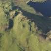
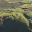
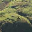
This fort occupies the rocky summit of Knock Scalbart at a height of 213m OD. The site is easily approached from all directions except the S and SE, where the steep fall of the ground provides strong natural protection. The fort measures 55m by 49m within a single stone wall which is now reduced for the most part to a band of debris in which numerous stretches of both faces are visible. On the NE, NW and SW the wall is 4.6m thick, but on the S, where it lies on the brink of a long and steep descent, it seems to have been less than 3m thick. The entrance is situated on the WSW, and measures 1.5m in width externally. The passage, whose N wall stands at least three coursesin height,
is checked for a door at a point 2.4m from the outside, and thereafter increases to a width of 2.1m. A gap about 3m wide in the wall debris on the E side of the fort is probably secondary.
Within the N portion of the interior of the fort,there are what appear to be the foundations of two circular houses, consisting of a low penannular bank (information from OS 6" map, {1924}) enclosing an area 8.5m in diameter, with an entrance gap facing W, and a short arc of a similar bank (RCAHMS 1971) together with a low sinuous scarp. In the absence of comparable structures in Kintyre, it is impossible, without excavation, to determine whether or not these are in fact houses contemporary with the fort; it is equally possible that they are associated with the two rectilinear enclosures formed by stone walls, one situated wholly and the other partly in the wall debris of the fort, which are clearly secondary.
On the highest part of the interior at the south end there are the remains of a cairn probably of Bronze Age date, consisting of a low mound of stones 10m in diameter and 0.5m in height, on which an Ordnance Survey triangulation station has been erected. A short distance west of the cairn a small platform, the purposes of which is not known, has been hewn out of the rock.
RCAHMS 1971, visited 1960.
The fort is as described and illustrated by the RCAHMS (1971). The two circular foundations closely resemble Iron Age hut circles, particularly in the manner they have been levelled into the slope. Their smooth lines contrast with the less regular style of the recilinear enclosures.
The alleged cairn, which seems largely earthen, lacks any distinctive cairn-like features. It is possibly the fortuitous result of earth-moving during the construction of the OS pillar. The 'platform' to the west is indistinct and may be the result of quarrying during the construction of the afore-mentioned pillar.
Surveyed at 1:10 000.
Visited by OS (JB) 2 November 1977.
NR 730 222 Neolithic polished stone (hornfels) axehead (168 x 68 x 32mm); found in October 2001 by Mr Angus Martin on an eroded part of the hillside close to the summit of the hill. Claimed as Treasure Trove (TT.62/01) and allocated to Argyll and Bute Council.
A Saville 2002
Field Visit (May 1960)
Cairn, Knock Scalbart.
On the summit of Knock Scalbart (216 m O.D.), lying within the defences of the fort NR72SW 25, there are the remains of a cairn, probably of Bronze Age date, consisting of a low mound of stones measuring 10 m in diameter and 0.5 m in height. An Ordnance Survey triangulation station has been erected on it.
RCAHMS 1971, visited May 1960
730222 cclvii (unnoted)
Note (23 September 2014 - 23 May 2016)
This fort encloses the summit of Knock Scalbart from which the ground falls away steeply on the S and SE. Roughly pear-shaped on plan, it measures 55m from NNW to SSE by a maximum of 49m transversely within a ruinous wall up to 4.6m in thickness, though it seems to reduce to less than 3m on the less easily accessible SE flank. The entrance is on the WSW, comprising an outer passage some 1.5m wide and 2.4m long, which broadens to 2.1m to the rear of door checks on either side; a gap in the wall on the E is probably secondary. Within the N half of the interior there are two probable round-houses, the better defined measuring about 8.5m in diameter within a low bank broken by an entrance on the W, while on the S there is also a small rock-cut platform beside a mound surmounted by the OS triangulation pillar. Later activity has also seen the construction of two small pens, one butting against the wall on the E, and the other within its thickness on the NE.
Information from An Atlas of Hillforts of Great Britain and Ireland – 23 May 2016. Atlas of Hillforts SC2059

