|
Prints and Drawings |
AGD 294/1 |
Records of the Royal Commission on the Ancient and Historical Monuments of Scotland (RCAHMS), Edinbu |
Plan and PTS inv fig 50 RCAHMS |
1967 |
Item Level |
|
|
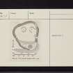
Prints and Drawings |
AGD 294/2 P |
Records of the Royal Commission on the Ancient and Historical Monuments of Scotland (RCAHMS), Edinbu |
Plan inv fig 50 RCAHMS |
1967 |
Item Level |
|
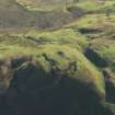 |
On-line Digital Images |
DP 056761 |
RCAHMS Aerial Photography Digital |
Oblique aerial view centred on the remains of the fort on Knock Scalbart, taken from the NW. |
31/10/2008 |
Item Level |
|
 |
On-line Digital Images |
DP 056765 |
RCAHMS Aerial Photography Digital |
Oblique aerial view centred on the remains of the fort on Knock Scalbart, taken from the E. |
31/10/2008 |
Item Level |
|
 |
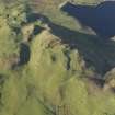
On-line Digital Images |
DP 056767 |
RCAHMS Aerial Photography Digital |
Oblique aerial view centred on the remains of the fort on Knock Scalbart with the quarries, enclosures and rig adjacent, taken from the NNW. |
31/10/2008 |
Item Level |
|
 |
On-line Digital Images |
DP 056770 |
RCAHMS Aerial Photography Digital |
Oblique aerial view centred on the remains of the fort on Knock Scalbart with the quarries, enclosures and rig adjacent, taken from the NW. |
31/10/2008 |
Item Level |
|
|
Manuscripts |
MS 36/175 |
Records of the Royal Commission on the Ancient and Historical Monuments of Scotland (RCAHMS), Edinbu |
Field notebook of K A Steer (RCAHMS). 'S8 - Dumfries, Dumbarton, Kintyre'. |
2/5/1955 |
Item Level |
|
 |
On-line Digital Images |
SC 2416543 |
Records of the Ordnance Survey, Southampton, Hampshire, England |
Knock Scalbart, NR72SW 25, Ordnance Survey index card, page number 1, Recto |
1958 |
Item Level |
|
 |
On-line Digital Images |
SC 2416544 |
Records of the Ordnance Survey, Southampton, Hampshire, England |
Knock Scalbart, NR72SW 25, Ordnance Survey index card, page number 2, Verso |
1958 |
Item Level |
|
 |
On-line Digital Images |
SC 2416545 |
Records of the Ordnance Survey, Southampton, Hampshire, England |
Knock Scalbart, NR72SW 25, Ordnance Survey index card, page number 3, Recto |
1958 |
Item Level |
|
 |
On-line Digital Images |
SC 2416546 |
Records of the Ordnance Survey, Southampton, Hampshire, England |
Knock Scalbart, NR72SW 25, Ordnance Survey index card, Recto |
1958 |
Item Level |
|
 |
On-line Digital Images |
SC 2416547 |
Records of the Ordnance Survey, Southampton, Hampshire, England |
Knock Scalbart, NR72SW 25, Ordnance Survey index card, Recto |
1958 |
Item Level |
|
|
All Other |
551 166/1/1 |
Records of the Ordnance Survey, Southampton, Hampshire, England |
Archaeological site card index ('495' cards) |
1947 |
Sub-Group Level |
|


