
Eilean Mor, St Cormac's Chapel And Burial-ground


Burial Ground (Period Unassigned), Chapel (Medieval)
Site Name Eilean Mor, St Cormac's Chapel And Burial-ground
Classification Burial Ground (Period Unassigned), Chapel (Medieval)
Alternative Name(s) St Cormac's Cave; Cill Mhic-charmaig; St Carmaig's Chapel
Canmore ID 38634
Site Number NR67NE 1
NGR NR 66654 75286
Datum OSGB36 - NGR
Permalink http://canmore.org.uk/site/38634


- Council Argyll And Bute
- Parish South Knapdale
- Former Region Strathclyde
- Former District Argyll And Bute
- Former County Argyll
NR67NE 1 66654 75286
(NR 6665 7528) Chapel (NR) (Cill Mhic-Charmaig)
OS 6" map (1900)
This chapel, a rectangular building, 38' x 20' externally, was used as an inn after 1600, hence the fireplaces in the W gable. It is partly medieval work, enclosing an earlier building 13' x 10'6" internally, with a barrel-vaulted roof, now forming the chancel.
Traditionally connected with Keills (NR68SE 2) and perhaps its 'Disert' in early times. Dedication of both to St Abban moccu Chormaig (c. 640) (M Campbell and M Sandeman 1964).
The chapel was surrounded by an open and nearly obliterated burial ground (D MacGibbon and T Ross 1896). There is a medieval tomb on the S side of the chancel.
T P White 1875
St Cormac's Chapel (DoE nameplate) is as described but the burial ground can no longer be recognised.
Visited by OS (DWR) 16 May 1973.
Descheduled.
Information from Historic Scotland, Certificate of Exclusion from Schedule dated 14 March 2000.
Field Visit (August 1984)
Eilean Mor is the largest and most westerly of the group of islands lying in the Sound of Jura at the mouth of Loch Sween, and known locally as 'the MacCormac Isles'. It lies about 6km SSW of Keills (No. 45) and 5.8km SW of Castle Sween (No. 119), and was undoubtedly the oilen l-suibhne ('island of Loch Sween') of the 17th-century Book of Clanranald (en.1). This records the repair by John, Lord of the Isles, in the middle of the 14th century, of the existing chapel of early 13th-century date. Although the surrounding waters are affected by strong tidal currents, an excellent anchorage is provided by a large sheltered inlet 150Ih NNE of the chapel. This building, with its associated cross of Early Christian date, stands at the S edge of a marshy area dividing the northern third of the island, situated on limestone, from the rockier S part which is composed of vertically bedded schists. The island was noted in the late 18th century for its excellent pasture (en.2), but evidence for cultivation is confined to the NW part, where there are numerous enclosures and clearance-cairns. Several buildings and a corn-drying kiln are situated close to the chapel, which was itself adapted for domestic use in the post-Reformation period. Some 250m SSW of the chapel (NR 665750) there are the remains of a drystone building, possibly another chapel, at the entrance to a small cave whose walls bear two incised crosses of early type. This site was probably used in the Early Christian period as a hermit's retreat, and the revival of this tradition is indicated by the inscription on a late medieval cross (infra, number 6), which formerly stood at the highest point of the island (NR 666751).
RCAHMS 1992, visited August 1994
[a detailed description of the chapel, the chapel (possible) and cave, settlement, and the funerary monuments and crosses can be found in RCAHMS 1992, No. 33, pp.66-74]
Measured Survey (14 August 1984)
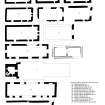
RCAHMS surveyed Eilean Mor chapel and burial ground on 14 August 1984 with plane-table and alidade producing a site plan at a scale of 1:400. The plan was redrawn in ink and published at a scale of 1:1000 (RCAHMS 1992, 66B).
Measured Survey (20 June 1984 - 21 June 1984)
RCAHMS surveyed Eilean Mor chapel and burial ground between 20-21 June 1984 producing upper and ground floor plans and sections at a scale of 1:100 and a detail of the exterior of the N window. The plan was redrawn in ink and published at a scale of 1:250 (RCAHMS 1992, 66C). The ground floor plan was also included in an illustration of comparative plans of medieval churches and chapels published at a scale of 1:250 (RCAHMS 1992, 11B).

