
Cnoc Araich


Fort (Period Unassigned)
Site Name Cnoc Araich
Classification Fort (Period Unassigned)
Canmore ID 38296
Site Number NR60NE 2
NGR NR 6925 0965
Datum OSGB36 - NGR
Permalink http://canmore.org.uk/site/38296


- Council Argyll And Bute
- Parish Southend
- Former Region Strathclyde
- Former District Argyll And Bute
- Former County Argyll
NR60NE 2 6925 0965.
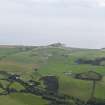
NR 693 097 The largest fort in Kintyre is situated on Cnoc Araich (90m OD) immediately N of North Machrimore farmhouse. The hill is a squat, flattish-topped feature of irregular shape and no great defensive strength; on the W it rises almost imperceptibly out of level ground, and the flanks on the other three sides are only moderately steep and for the most part less than 9m in height. The defences enclosure an area of about 2.5ha (six and a quarter acres), measuring 204m by 177m. They have consisted of triple ramparts with double, or possibly triple, ditches, which closely followed the outline of the hill, the inner rampart being drawn round the edge of the summit area wherever possible and the other elements round the flanks. At the present time the defences are much wasted, and even where best preserved are largely overgrown with whins. Except at one point on the SW, the inner rampart has been completely obliterated by former cultivation of the hill-top, and although the other two ramparts still survive on the W half of the site to a height of about 0.6m, little can now be seen of them on the E half. As far as can be judged from their superficial appearance, however, the ramparts have never been very substantial, and have been formed simply of heaped earth and stones cast out of the ditches; minor irregularities in lay-out, including small angular changes of direction too small to register on the plan, show that the work was done by gang labour. Without excavation it is impossible to tell which of the numerous gaps in the defences represent original entrances, and any traces of buildings that may have existed in the interior have been destroyed by cultivaton.
RCAHMS 1971, visited 1965
This fort is as described by the RCAHMS. Most of the whins have been cleared from the site in recent years.
Surveyed at 1:2500.
Visited by OS (NKB) 7 October 1977
Reference (1957)
This site is noted in the ‘List of monuments discovered during the survey of marginal land (1951-5)’ (RCAHMS 1957, xiv-xviii).
Information from RCAHMS (GFG), 24 October 2012.
Note (9 October 2014 - 23 May 2016)
This fort encloses an irregular area of 2.53ha on the summit of this low flat-topped hill, which forms the eastern end of a ridge of higher ground to the W. The defences comprise a belt 18m deep of three ramparts with intermediate ditches, though the inner rampart has been reduced to little more than a scarp and the others are nowhere more than 0.6m in height. For the greater part of the circuit, however, the defences are submerged in gorse and whins, and it is impossible to be certain that any of the gaps recorded on the RCAHMS plan drawn up in 1965 are original entrances, though four, on the N, E, SSW and SW, provide suitable points of access. The interior, which has been improved, is under rough pasture. Several small later quarries have been cut into the defences around the margins of the hill.
Information from An Atlas of Hillforts of Great Britain and Ireland – 23 May 2016. Atlas of Hillforts SC2196

