Accessibility

Font Size

100% 150% 200%

Background Colour

Default Contrast
Close Reset

Islay, Rhuvaal Lighthouse And Keepers' Houses

Lighthouse (19th Century) (1857), Lighthouse Keepers House(S) (19th Century), Sundial (19th Century)

Site Name Islay, Rhuvaal Lighthouse And Keepers' Houses

Classification Lighthouse (19th Century) (1857), Lighthouse Keepers House(S) (19th Century), Sundial (19th Century)

Alternative Name(s) Ruvaal Lighthouse; Rudh A' Mhail; Rudha Mhail; Rubh' A' Mhail; Rubha' A' Mhail; Sound Of Islay

Canmore ID 38155

Site Number NR47NW 4
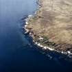
NGR NR 42576 79166

NGR Description Centred NR 42576 79166

Datum OSGB36 - NGR

Permalink http://canmore.org.uk/site/38155

Ordnance Survey licence number AC0000807262. All rights reserved.
Canmore Disclaimer. © Bluesky International Limited 2025. Public Sector Viewing Terms

Toggle Aerial | View on large map

Digital Images

Islay, Rhuvaal Lighthouse, view from E (from the sea)
Islay, Rhuvaal Lighthouse, view from E (from the sea)Islay, Rudh A' Mhail, Rhuvaal Lighthouse
General view of the lighthouse and compound from E (from the sea)Islay, Rudh A' Mhail, Rhuvaal Lighthouse
View from SW of lighthouse, with range of keepers' houses in foregroundPhotographic copy of drawing showing details and enlarged plan of beam.  Section through a door.  and sections through stair and gutter.
Northern Lights, sheet No.5Islay, Rudh A' Mhail, Rhuvaal Lighthouse
General view of the lighthouse and compound from E (from the sea)Ruvaal Lighthouse, Islay.
View from West.Ruvaal Lighthouse, Islay.
View of sundial in grounds.Photographic copy of map showing location of proposed  lighthouse and road.
Northern Lights, sheet No.1Ruvaal Lighthouse, Islay.
View from West.Ruvaal Lighthouse, Islay.
View from West.Islay, Rudh A' Mhail, Rhuvaal Lighthouse
General view of the lighthouse and compound from E (from the sea)Islay, Rudh A' Mhail, Rhuvaal Lighthouse
View from SW of store near to lighthouse jetty, situated directly to the S of the compoundOblique aerial view centred on the lighthouse, taken from the N.
Islay, Rudh A' Mhail, Rhuvaal Lighthouse
View from S of SW side of range of keepers' houses, and adjacent out-house (left)Islay, Rudh A' Mhail, Rhuvaal Lighthouse
View from SW of lighthouse, with range of keepers' houses in foregroundRuvaal Lighthouse, Islay.
View of sundial in grounds.Islay, Rudh A' Mhail, Rhuvaal Lighthouse
General view of lighthouse and compound from SRuvaal Lighthouse, Islay.
View of entrance doorway and inscribed panel.Ruvaal Lighthouse, Islay.
View from West.General oblique aerial view of Rhuvaal Lighthouse, taken from the E.Islay, Rudh A' Mhail, Rhuvaal Lighthouse
View from E of NE side of range of keepers' houses (privately occupied since automation of light several years before this survey)Islay, Rudh A' Mhail, Rhuvaal Lighthouse
General view of the lighthouse and compound from E (from the sea)Photographic copy of drawing showing a plan, elevation of roof of dwelling houses and section through dwelling houses.
Northern Lights, sheet No.4Photographic copy of drawing showing sections across road, drain, embankment, cutting and forming.  In addition a longitudinal section of the road.
Northern Lights, sheet No.6Oblique aerial view centred on the lighthouse, taken from the NE.
Islay, Rudh A' Mhail, Rhuvaal Lighthouse
Detailed view from S of two gables at SE end of range of keepers' houses, with lighthouse tower directly behindRuvaal Lighthouse, Islay.
Detail of inscribed panel above entrance doorway.Ruvaal Lighthouse, Islay.
Detail of lantern.Islay, Rudh A' Mhail, Rhuvaal Lighthouse
View of lighthouse and range of keepers' houses from SSW, seen from inside the compound (with sundial plinth in foreground)Oblique aerial view centred on the lighthouse, taken from the N.
Oblique aerial view centred on the lighthouse, taken from the E.
Islay, Rudh A' Mhail, Rhuvaal Lighthouse
General view of lighthouse and compound from SIslay, Rudh A' Mhail, Rhuvaal Lighthouse
View of lighthouse and range of keepers' houses from SSW, seen from inside the compound (with sundial plinth in foreground)Islay, Rudh A' Mhail, Rhuvaal Lighthouse
View from E of NE side of range of keepers' houses (privately occupied since automation of light several years before this survey)Detail of sundial and gnomon, Ruvaal Lighthouse, Islay.Islay, Rudh A' Mhail, Rhuvaal Lighthouse
View from S of SW side of range of keepers' houses, and adjacent out-house (left)Islay, Rudh A' Mhail, Rhuvaal Lighthouse
Detailed view from SW of entrance to lighthouse tower, with commemorative plaque aboveIslay, Rudh A' Mhail, Rhuvaal Lighthouse
Detailed view from S of two gables at SE end of range of keepers' houses, with lighthouse tower directly behindIslay, Rhuvaal Lighthouse And Keepers' Houses, NR47NW 4, Ordnance Survey index card, RectoIslay, Rudh A' Mhail, Rhuvaal Lighthouse
General view of lighthouse and compound from SIslay, Rudh A' Mhail, Rhuvaal Lighthouse
View from SW of lighthouse, with range of keepers' houses in foregroundIslay, Rudh A' Mhail, Rhuvaal Lighthouse
View from SW of store near to lighthouse jetty, situated directly to the S of the compound

Administrative Areas

  • Council Argyll And Bute
  • Parish Killarow And Kilmeny
  • Former Region Strathclyde
  • Former District Argyll And Bute
  • Former County Argyll

Archaeology Notes

NR47NW 4 centred 42576 79166

Rhuvaal Lighthouse [NAT]

OS 1:10,000 map, 1980.

Earlier 19th century.

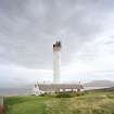
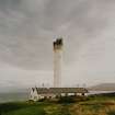
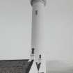
TOWER: Circular. Tall. Ashlar, painted. Parapet. (No windows).

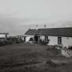
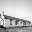
KEEPERS' HOUSES: 1 storey Rubble, painted. Double-

gabled. Slate roofs.

BOUNDARY WALLS.

RCAHMS 1984.

During October 1999, RCAHMS carried out an extensive photographic survey of Rhuvaal Lighthouse. This was undertaken in order to enhance and augment the existing holdings of the National Monuments Record Scotland.

Visited by RCAHMS (MKO), August 1999.

Activities

Construction (1869)

Light estbalished in 1869.

K Allardyce and E M Hood 1986

Field Visit (September 1981)

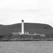
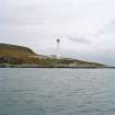
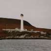
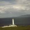
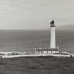
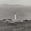
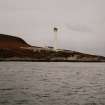
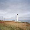
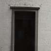
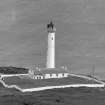
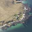
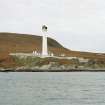
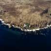
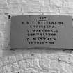
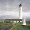
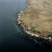
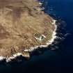
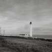
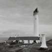
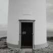
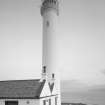
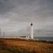
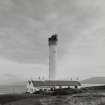
This lighthouse stands within its walled precincts on the headland at the N entrance to the Sound of Islay. It was erected between 1857 and 1859 to the design of the engineers, David and Thomas Stevenson, for the Northern Lighthouse Board, which was then under the financial control of the Board of Trade.(Mair 1978; The need for navigational lights through the Sound of Islay had been confirmed by Robert Stevenson as early as 1835, Parliamentary Papers 1836; 1861) An inscribed panel over the main W doorway into the tower commemorates the date 1857, the names of the engineers, the contractor, A MacDonald, and the inspector, D Matthew.

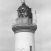
The tower measures 5.8m in diameter and rises to a height of about 36m at the lantern. It is constructed of lime-washed brick laid in English bond; plain sandstone dressings are employed for the windows and doorways, and a moulded corbel-course supports the balcony. The interior contains a stone built newel stair and an original lens-mechanism inscribed with the names of the engineers and the date 1858.

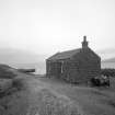
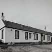
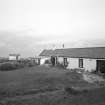
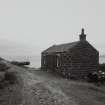
A short distance SW of the tower there is a range of lightkeepers' cottages, also built of lime-washed brick in English bond with sandstone dressings. The original nucleus of this range measures 23.1m in length from NW to SE by 9.3m transversely, and, prior to the alterations of 1959-60, comprised a store at the NW end and two separate domestic units which had respectively three and four heated rooms grouped around a central spine-wall. According to evidence presented to a Royal Commission investigating the lighthouse service in 18 59-61, the newly completed dwellings at Ruvaal were critically described as being 'more like dog kennels than anything else'. (quoted by Munro 1979)

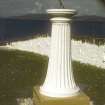
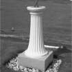
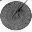
On the SE side of the track leading from the main gate into the lighthouse establishment there is a sundial with fluted pedestal and brass dial engraved with the name of the lighthouse and that of the makers, Adie and Son, Edinburgh.

RCAHMS 1984, visited September 1981.

Modification (1987)

Automated in 1987.

K Allardyce and EM Hood 1986

Photographic Survey (October 1999)

During October 1999, RCAHMS carried out an extensive photographic survey of Rhuvaal Lighthouse. This was undertaken in order to enhance and augment the existing holdings of the National Monuments Record Scotland.

Visited by RCAHMS (MKO), August 1999.

References

MyCanmore Image Contributions


Contribute an Image

MyCanmore Text Contributions