
Islay, Duisker


Burial Ground (Early Medieval) - (Medieval), Chapel (Early Medieval) - (Medieval)
Site Name Islay, Duisker
Classification Burial Ground (Early Medieval) - (Medieval), Chapel (Early Medieval) - (Medieval)
Alternative Name(s) Duisker 2
Canmore ID 37690
Site Number NR36NE 2
NGR NR 36025 66790
Datum OSGB36 - NGR
Permalink http://canmore.org.uk/site/37690


- Council Argyll And Bute
- Parish Killarow And Kilmeny
- Former Region Strathclyde
- Former District Argyll And Bute
- Former County Argyll
NR36NE 2 3602 6678.
(NR 3602 6679) Chapel (NR) (In Ruins) Burial Ground (NR)
OS 6" map, Argyllshire, 2nd ed., (1900)
The remains of a chapel, consisting of a low crumbling grass-covered wall, lying in the centre of its circular burial-ground, which is about 15 yards in diameter, enclosed by a bank. Beyond its being ancient nothing is known of the chapel.
Name Book 1878.
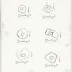
This unusually small chapel measures 3.5m NE-SW by 3.2m within a turf-covered wall, 0.9m high and little more than 1.0m in actual width,. A central placed break along the SW wall shows an entrance position.
The enclosing burial ground is approximately 12.5m square with angles rounded; its wall is similar to that of the chapel but more upstanding.
Surveyed at 1:10 000.
Visited by OS June 1978.
Field Visit (September 1975)
(NR 360 667) The turf-grown footings of this chapel stand within a burial-ground about 200m SW of Duisker farmhouse and 600m WNW of the chapel NR36NE 1. The building measures about 3.6m from ENE to WSW by 2.8m transversely within walls some 0.8m in thickness, and the entrance lay in the WSW wall. The burial-ground is approximately circular, measuring about 13m in diameter within a drystone wall about 1.3m in thickness; the entrance appears to have been in the N sector. There are no identifiable tombstones, but a low stony mound immediately to the E of the chapel may mark the position of a grave.
RCAHMS 1984, visited September 1975.
Measured Survey (September 1975)
RCAHMS surveyed the chapel and burial-ground at Duisker 2 at a scale of 1:100. The plan of the chapel was redrawn in ink and published at a reduced scale (RCAHMS 1984, fig. 26A), with a site plan including the burial-ground at a smaller scale (fig. 170D).

