|
Prints and Drawings |
DC 40 |
Records of the Royal Commission on the Ancient and Historical Monuments of Scotland (RCAHMS), Edinbu |
Topographical map of islands Jura, Islay, Colonsay, Oronsay.
Inv.p.1. RCAHMS Copy in library.
(Currently missing - 31/5/96) |
|
Item Level |
|
|
Photographs and Off-line Digital Images |
DC 45 P |
Records of the Royal Commission on the Ancient and Historical Monuments of Scotland (RCAHMS), Edinbu |
Distribution map of forts, broch, duns. Inv. p.21. RCAHMS |
1984 |
Item Level |
|
|
Photographs and Off-line Digital Images |
DC 305 P |
Records of the Royal Commission on the Ancient and Historical Monuments of Scotland (RCAHMS), Edinbu |
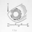
Plan ink 1:400 RCAHMS INv no. 234 |
1980 |
Item Level |
|
|
Prints and Drawings |
DC 306 |
Records of the Royal Commission on the Ancient and Historical Monuments of Scotland (RCAHMS), Edinbu |
PTS p encil 1:400 RCAHMS |
1980 |
Item Level |
|
 |
On-line Digital Images |
SC 2257089 |
Records of the Royal Commission on the Ancient and Historical Monuments of Scotland (RCAHMS), Edinbu |
Plan ink 1:400 RCAHMS INv no. 234 |
1980 |
Item Level |
|
 |
On-line Digital Images |
SC 2413977 |
Records of the Ordnance Survey, Southampton, Hampshire, England |
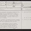
Islay, Sruthan Na Cille, NR34NE 26, Ordnance Survey index card, page number 1, Recto |
1958 |
Item Level |
|
 |
On-line Digital Images |
SC 2413978 |
Records of the Ordnance Survey, Southampton, Hampshire, England |
Islay, Sruthan Na Cille, NR34NE 26, Ordnance Survey index card, page number 2, Recto |
1958 |
Item Level |
|
 |
On-line Digital Images |
SC 2413979 |
Records of the Ordnance Survey, Southampton, Hampshire, England |
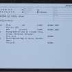
Islay, Sruthan Na Cille, NR34NE 26, Ordnance Survey index card, Recto |
1958 |
Item Level |
|
|
Prints and Drawings |
DC 45 |
Records of the Royal Commission on the Ancient and Historical Monuments of Scotland (RCAHMS), Edinbu |
Distribution map of forts, broch, duns. Inv. p.21. RCAHMS |
1984 |
Item Level |
|
|
All Other |
551 166/1/1 |
Records of the Ordnance Survey, Southampton, Hampshire, England |
Archaeological site card index ('495' cards) |
1947 |
Sub-Group Level |
|


