
Islay, Sruthan Na Cille


Dun (Later Prehistoric)(Possible)
Site Name Islay, Sruthan Na Cille
Classification Dun (Later Prehistoric)(Possible)
Canmore ID 37549
Site Number NR34NE 26
NGR NR 37875 45781
Datum OSGB36 - NGR
Permalink http://canmore.org.uk/site/37549


- Council Argyll And Bute
- Parish Kildalton And Oa
- Former Region Strathclyde
- Former District Argyll And Bute
- Former County Argyll
NR34NE 26 3787 4578.
NR 379 456 On a promontory overlooking Struth na Cille is a raised mound 50ft in diameter and a lower mound or circular enclosure, also 50ft in diameter. Both are enclosed by walling on 3 sides, the steep east side being undefended. A lower terrace on the south west is also walled. The site is 140ft by 65ft exclusive of terrace.
F Newall 1964.
NR 3788 4578 A strongly constructed enclosure situated on a lower part of a rocky spur which is steep sided on the east but easily approached from the west.
This enclosure is approximately 18.5m in overall diameter with a level internal area 8m across. The turf covered wall is up to 0.6m high and has an outer face of large boulders visible for most of the circumference; there is no identifiable inner face but a wall width of about 4m is suggested. The entrance cannot be traced with certainly but it was probably in the north west.
The spur stands amidst cultivated ground with, nearby, rocky crags and high ground. Although the enclosure is substantial its pastoral rather than defensive position suggests it to be a homestead.
The raised mound noted by Newall (1964) is the grass covered top of the spur to the east but there is no trace of any structure upon it. Surveyed at 1:10000.
Visited by OS (BS) 20 June 1978
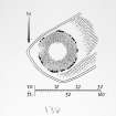
Measured Survey (1979)
RCAHMS surveyed the dun at Cnoc Grianail in 1979 at 1:400 using plane-table and self-reducing alidade. The plan was redrawn in ink and published at a reduced size (RCAHMS 1984, fig. 108A).
Field Visit (May 1980)
NR 378 457. What may be the remains of a dun lie on a level shelf at the SW end of a short ridge 650m W of Portintruan. The site is unusual for a dun since, while rising between 2m and 3m above the level of the surrounding ground, it has no natural defensive strength and is overlooked from the immediate NE by the summit of the ridge, which is unoccupied except for two recent animal pens. In form and size, however, the structure is comparable with many duns recorded elsewhere.
The near circular enclosure has an overall diameter of 19m. Its wall survives as a broad band of heavy grass-covered rubble standing up to 0.5m high. The outer face, which can be traced around much of the circumference, is formed of large boulders, but nowhere can more than one course of walling be seen. No inner facing-stones can be identified, but from the extent and density of the rubble spread, the original thickness of the wall may be estimated at some 3.5m. On the NE arc a line of narrow stones, which is visible about 1m within the outer face of the wall, may be an internal revetment designed to give additional strength to the structure; it may, however, belong to a later building phase. The position of the entrance is unclear, but it probably lay on the W, where there is an absence of outer facing-stones and a marked thinning in the tumbled rubble. Traces of a subrectangular structure some 7m long with a possible entrance on the S occupy the centre of the interior; it was probably built at a later date and may be contemporary with a stone wall, 0.6m thick and of no great age, which extends along the sides and round the SW edge of the ridge.
RCAHMS 1984, visited May 1980

