|
Prints and Drawings |
DC 40 |
Records of the Royal Commission on the Ancient and Historical Monuments of Scotland (RCAHMS), Edinbu |
Topographical map of islands Jura, Islay, Colonsay, Oronsay.
Inv.p.1. RCAHMS Copy in library.
(Currently missing - 31/5/96) |
|
Item Level |
|
|
Photographs and Off-line Digital Images |
AG 12979 |
Records of the Royal Commission on the Ancient and Historical Monuments of Scotland (RCAHMS), Edinbu |
(Larger) RCAHMS |
1983 |
Item Level |
|
|
Photographs and Off-line Digital Images |
DC 376 P |
Records of the Royal Commission on the Ancient and Historical Monuments of Scotland (RCAHMS), Edinbu |
Comparative hut circle plans 1:400 RCAHMS (Print Filed NR36SE 2) Inv no. 269 |
|
Item Level |
|
|
Prints and Drawings |
DC 383 |
Records of the Royal Commission on the Ancient and Historical Monuments of Scotland (RCAHMS), Edinbu |
PTS pencil 1:200 RCAHMS |
1979 |
Item Level |
|
|
Prints and Drawings |
DC 44 |
Records of the Royal Commission on the Ancient and Historical Monuments of Scotland (RCAHMS), Edinbu |
Distribution map of hut circles, field systems, settlement and burnt mounds.
Inv p.12 RCAHMS. Copy in library. |
1984 |
Item Level |
|
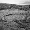 |
On-line Digital Images |
SC 2254431 |
Records of the Royal Commission on the Ancient and Historical Monuments of Scotland (RCAHMS), Edinbu |
Hut circle, Kilchiaran, Islay; larger hut circle from ESE |
1983 |
Item Level |
|
 |
On-line Digital Images |
SC 2413510 |
Records of the Ordnance Survey, Southampton, Hampshire, England |
Islay, Kilchiaran, NR25NW 41, Ordnance Survey index card, page number 1, Recto |
1958 |
Item Level |
|
 |
On-line Digital Images |
SC 2413511 |
Records of the Ordnance Survey, Southampton, Hampshire, England |
Islay, Kilchiaran, NR25NW 41, Ordnance Survey index card, page number 2, Recto |
1958 |
Item Level |
|
 |
On-line Digital Images |
SC 2413512 |
Records of the Ordnance Survey, Southampton, Hampshire, England |
Islay, Kilchiaran, NR25NW 41, Ordnance Survey index card, Recto |
1958 |
Item Level |
|
|
All Other |
551 166/1/1 |
Records of the Ordnance Survey, Southampton, Hampshire, England |
Archaeological site card index ('495' cards) |
1947 |
Sub-Group Level |
|


