
Campstone Hill, Raedykes


Ring Cairn (Neolithic) - (Bronze Age), Stone Circle (Neolithic) - (Bronze Age)
Site Name Campstone Hill, Raedykes
Classification Ring Cairn (Neolithic) - (Bronze Age), Stone Circle (Neolithic) - (Bronze Age)
Alternative Name(s) Raedykes South
Canmore ID 37182
Site Number NO89SW 6
NGR NO 83226 90655
Datum OSGB36 - NGR
Permalink http://canmore.org.uk/site/37182


- Council Aberdeenshire
- Parish Fetteresso
- Former Region Grampian
- Former District Kincardine And Deeside
- Former County Kincardineshire
NO89SW 6 83226 90655
See also NO89SW 7, NO89SW 8, NO89SW 9.
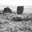
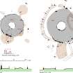
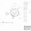
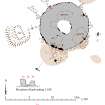
This ring-cairn and its surrounding stone-circle are situated 80m NW of NO89SW 9. The cairn measures 10.2m in diameter over all by 0.6m in height; the interior is at least 2.4m in diameter but only four kerbstones (slabs up to 0.8m by 0.2m and 0.6m in height) survive. The outer kerb is composite, comprising a ring of kerbstones which incorporates a series of pillar-stones and a three-stone setting; twenty-five kerbstones are visible and they are probably graded in height with the tallest of the surviving stones(0.6m) on the SW and the lowest (0.3m) on the NE. Originally there were probably seven pillars (ranging from 0.8m to 1.1m in height) three are still upright (SE, E, ENE), one is leaning (NW), one is fallen (WNW) and two are missing (NE and N). The three-stone setting lies on the SSW and consists of a pair of uprights flanking a boulder 0.5m in height; the E slab measures 1.4m by 0.4m at the base and 1.2m in height, the W slab 0.9m by 0.4m and 0.7m in height. The pillars were probably graded in height, with the lowest on the N, where they were also more closely spaced. Set in the body of the cairn behind the stone setting there are two upright slabs and a boulder which suggest the presence of a buried feature, possibly a funnel-shaped passage, within the mound. The stone circle is 13.9m in diameter but only five stones remain; two are upright (SSW and NNE), two fallen (NNW and WNW) and one has been reduced to a stump (ESE). The SSW stone (0.8m by 0.3m at the bsae and 1.4m high) probably forms the E element of a pair of stones set opposite the three-stone setting on the kerb of the cairn; the W stone is missing, but a small stone 1.2m in length, which lies adjacent to the E stone, may have been set between them. The spacing of the surviving stones, and three possible stone holes on the W suggests that there were originally thirteen stones in the circle; they were probably set closer together around the N, with the smallest (0.8m high) on the NNE directly opposite across the cairn from the stone settings on the SSW.
Name Book 1864; J Ritchie 1923; A S Henshall 1963; A Thom, A S Thom and A Burl 1980; RCAHMS 1984.
Field Visit (2 May 1957)
This site was included within the RCAHMS Marginal Land Survey (1950-1962), an unpublished rescue project. Site descriptions, organised by county, are available to view online - see the searchable PDF in 'Digital Items'. These vary from short notes, to lengthy and full descriptions. Contemporary plane-table surveys and inked drawings, where available, can be viewed online in most cases - see 'Digital Images'. The original typecripts, notebooks and drawings can also be viewed in the RCAHMS search room.
Information from RCAHMS (GFG) 19 July 2013.
Publication Account (1986)
Strung along the crest of Camps tone Hill at c 190m OD, this important group of early ritual sites has open views to the east. The first feature, 280m north-west of West Raedykes, is a fme ring cairn, 9.4m in diameter and 0.4m high, with the kerbed open central area, 3.9m in diameter, clearly visible. Nine stones up to 1m high survive in the surrounding stone circle, 17 m in diameter. 20m to the west-northwest is an oval cairn, 8.5m by 7.7m and 0.5m high, which is either a ring cairn or a robbed round cairn. The third site, 15m further to the west-north-west, is very similar. The fourth feature stands higher than the others arid 80m north-west of the fIrst; it comprises another ring cairn, 10.2min diameter and 0.6m high, within a stone circle 13.9m in diameter, of which five of the possible 13 stones remain. A close relationship with the recumbent stone circle tradition can be seen on the south-south-west arc of the cairn, where two tall stones are set close together (the western is 1.7m and the eastern is 1.1m tall) with the stump of another in between. Other pillar stones protrude at intervals from the kerb. This emphasis on the south-west was echoed in the surrounding stone circle.
Information from ‘Exploring Scotland’s Heritage: Grampian’, (1986).
Field Visit (13 April 2005)
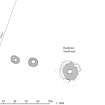
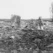
A group of at least two ring-cairns, and possibly as many as four, is strung out over a distance of some 100m on the summit of Campstone Hill. Two of them have formal kerbs and are surrounded by stone circles (see also NO89SW 9), but the other two are little more than featureless ring-banks measuring about 8m in overall diameter (NO89SW 7-8). By and large, the cairns command an open aspect, which on the SE extends to the coast around Stonehaven, but the view from the ring-cairn at the SE end of the group is restricted by the rising ground to the NW, and is hidden from the summit. All lie in rough grazing, now partly colonised by gorse, amidst extensive remains of field-banks and clearance cairns.
This ring-cairn and its surrounding stone circle (NO89SW 6) lies at the NW end of the group separated from the others by a post-and-wire fence. Of the four, this cairn is the most impressive. Overall, the cairn measures 10.5m in diameter and up to 0.6m in height, defined externally by a near-continuous kerb of predominantly pink granite blocks and taller grey and pink granite pillar-stones, and it also incorporates a three-stone setting of grey granite stones on the SSW. The internal court measures at least 2.4m in diameter, but only four kerbstones survive, the two taller and more substantial blocks occurring on the SW, where they are at least 0.27m taller than the two on the E. The outer kerbstones, twenty-eight of which remain in place, are taller in the S, though they do not appear to be regularly graded in height, but the pillar-stones increase in height towards the SW, and the stones forming the setting on the SSW are the tallest on the line of the kerb. The setting comprises two upright slabs standing to either side of a squat boulder; the west stone slab measures 1.65m in height, 0.5m taller than its partner to the east, and is the tallest stone of the monument. The squat boulder between them may be the base of a pillar, the shattered remains of which lie embedded in the turf immediately outside the kerb (Henshall 1963a, 401). Behind these stones, two thin slabs and a small triangular boulder are visible within the body of the cairn, the former set upright at right angles to the outer kerb, suggesting perhaps two radial divisions that focus on the SW.
The pillar-stones occur at intervals of between 2m and 2.6m in the kerb. Four of them remain in situ while a fifth on the WNW has fallen outwards. The positions of at least another two can be identified, corresponding with gaps where the kerb has been robbed away on the NE and SE. Though the ring of the pillar-stones is incomplete, it is evidently graded in height towards the SW, rising from 0.71m on the ENE to 0.94m on the SE. Several hollows in the body of the ring-cairn indicate stone robbing, the largest in the SE sector, where the upcast has been thrown outwards. This area of upcast corresponds with the scatter of stones shown on Ritchie’s plan published in PSAS in 1923 (1923, 24).
The stone circle surrounding the ring-cairn measures 14m in diameter, and may have comprised originally thirteen or fourteen stones, of which at least seven grey granite orthostats remain. Of these, three are in situ (SSW, ESE and NNE), though that on the ESE has been reduced to a stump; two have fallen (NNW and WNW); another is reduced to no more than a fragment (W); and the last lies flat and displaced in front of the three-stone setting (SSW). Here too the orthostats are graded in height, with the tallest stone standing 1.34m high on the SSW, and the shortest only 0.8m on the NNE. This last orthostat, rather than standing symmetrically in front of the three stone setting of the kerb, is set a little to one side. This may indicate that the prone slab lying in the mass of loose stones in front of the setting originally stood in an equivalent position on the other side, forming an opposing arrangement of orthostats on the line of the circle.
Visited by RCAHMS (ARG) 13 April 2005
Measured Survey (15 April 2005)
RCAHMS surveyed the Campstone Hill, Raedykes ring cairns on 15 April 2005 with plane table and self-reducing alidade producing a site at a scale of 1:500. The survey drawing was later used as the basis for an illustration produced in ink and finished in vector graphics software at a scale of 1:1000.
Measured Survey (13 April 2005)
RCAHMS surveyed the Campstone Hill, Raedykes stone circle and ring cairn on 13 April 2005 with plane table and alidade producing a plan and section of the site and an elevation of the kerb setting at a scale of 1:100. The plan, section and elevation were used as the basis for an illustration, produced in ink and finished in vector graphics software, that was published at a scale of 1:250 (Welfare 2011, fig. 7.16).

