Measured Survey


Date 13 April 2005
Event ID 1153774
Category Recording
Type Measured Survey
Permalink http://canmore.org.uk/event/1153774
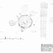
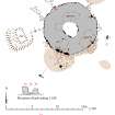
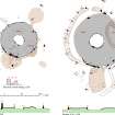
RCAHMS surveyed the Campstone Hill, Raedykes stone circle and ring cairn on 13 April 2005 with plane table and alidade producing a plan and section of the site and an elevation of the kerb setting at a scale of 1:100. The plan, section and elevation were used as the basis for an illustration, produced in ink and finished in vector graphics software, that was published at a scale of 1:250 (Welfare 2011, fig. 7.16).