
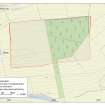
Normandykes


Temporary Camp (Roman)
Site Name Normandykes
Classification Temporary Camp (Roman)
Alternative Name(s) Hilton; Oldtown; Peterculter
Canmore ID 37075
Site Number NO89NW 1
NGR NO 82970 99380
NGR Description Centred NO 82970 99380
Datum OSGB36 - NGR
Permalink http://canmore.org.uk/site/37075


- Council Aberdeen, City Of
- Parish Peterculter
- Former Region Grampian
- Former District City Of Aberdeen
- Former County Aberdeenshire
NO89NW 1 centred 82970 99380
(Centred NO 8297 9938) Normandykes (NAT) Roman Camp (R)
OS 6" map, (1959).
NO89NW 1.01 NO 834 997 Excavation
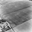
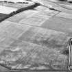
The Roman Marching Camp of Normandykes was proved by excavation in 1935, by I A Richmond and J MacIntyre (Richmond 1936). It encloses an area of 120 acres and is probably Antonine or Severan in date. It has six gates defended by tutuli (St Joseph 1958).
M V Taylor and R S Collingwood 1936; J K S St Joseph 1958.
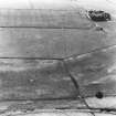
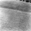
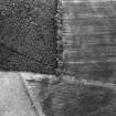
No really convincing remains can be seen on the surface but the N rampart is no doubt represented, for its E part by the bank bounding the wood on the N.
O G S Crawford 1949.
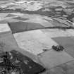
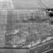
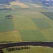
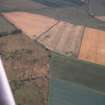
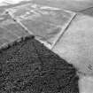
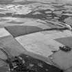
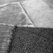
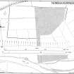
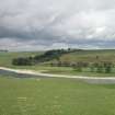
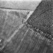
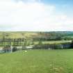
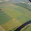
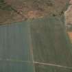
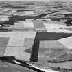
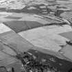
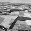
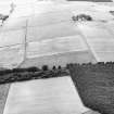
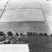
The site of this Roman Camp lies on top of the broad hill above the old ford across the River Dee (NO89NW 7) No traces of the west, south, and east sides of the camp can be seen in cultivated fields. However, in the latter side from the bend of the wood at NO 8340 9949, a mutilated earth bank, with a slight ditch on its east side, runs northwards along the edge of the wood to its NE corner; but this bank appears to continue south-westwards from the bend following the edge of the wood, and it therefore may be a later plantation bank. From the NE corner, a broad bank with a ditch on its north side, runs westwards along the edge of the wood. Here, the bank is 6.0m wide and c.2.0m high, with a flat top c.3.0m broad; the ditch is 4.0m wide. The bank deteriorates as it runs westwards and assumes the appearance of a plantation bank as it approaches the NW corner of the wood. From a point where a stream cuts through the bank, c.400m west of the NE corner of the wood, there is no trace of the ditch. From the NW corner of the wood, a scarp c.1.4m high continues to the NW corner of the camp. No features were noted within the area of the camp.
Revised at 1/2500.
Visited by OS (W D J) 27 November 1961; Visible on J K S St Joseph air photograph D58-9: V 19 and V 17.
Visible on air photographs AAS/93/12/G23/27-30. Copies held by Grampian Regional Council.
Information from M Greig, Grampian Regional Council, March 1994.
This camp is situated at an altitude of between 50 and 75m OD on top of the broad hill above the old across the River Dee.
[Air photographic imagery listed].
NMRS, MS/712/36.
Publication Account (17 December 2001)
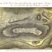
In 1801, Colonel Shand appears to have been the first to interpret Normandykes as Roman in date (Chalmers 1807: i, 125). The Statistical Account of 1795 refers to the ‘Norman’s Dyke’ as a Danish camp, noting that some people also believed that it dated to the time of William the Conqueror (Sinclair 1795b: xvi, 380–1). This view was corrected for the New Statistical Account of 1845, noting that the work of Shand and others had confirmed that the camp was Roman in date, probably belonging to the campaigns of Lollius Urbicus (NSA 1845: xii, 108). Captain Henderson produced a plan of the camp which was reproduced in Chalmers’ Caledonia (1807: i, opp. 125).
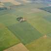
The camp lies just to the south of the village of Peterculter, on a low ridge on the north side of the River Dee. It measures about 895m from east to west by about 510m, enclosing an area of some 44.3ha (109 acres). The majority of the camp lies in arable fields, and much of the perimeter has been recorded as cropmarks from the air, but the eastern part of the north rampart and ditch survives as the north side of a plantation, accentuated by the superimposition of a plantation bank. This ‘rampart’ appears to be up to 6.3m in width and 1.4m in height, with a probable drain cut along the original line of the ditch. The western part of the north side lies under a stone wall. In addition, the rampart is detectable on the east side at the point where it is crossed by a field boundary, where it is almost 10m wide and 0.3m high.
No entrance is visible in the upstanding sector of the camp, but the presence of tituli in the western part of the south side and in the centre of the west suggests that the camp probably had six gates. In addition, Captain Henderson also illustrated a titulus in the centre of the east side (Chalmers 1807: i, opp 125).
The site was subject to excavations by Richmond and McIntyre in 1935, who ‘verified with the spade the Roman origin’ of the camp, and intended to return (Taylor 1936: 237). Further details are not provided, but Simpson records a trial excavation conducted in October 1936 with Richmond and McIntyre near the north-west corner under the stone dyke of the field wall (Simpson 1943: 57–8; Crawford 1949: 112). Further excavations were undertaken in 1971 by St Joseph in a field on the north side of the camp, revealing a small ditch measuring 0.5m in width and 0.15m in depth (RCAHMS St Joseph Collection: Notebook 6). Small-scale excavations along a forest track through the camp in 2006 recovered at least three probable ovens and many more features interpreted as hearths (Scotia Archaeology 2006).
The camp bends in the south side, just to the east of the titulus. There may be a corresponding slight bend opposite in the north side if the ditch follows the field boundary for its west sector (as illustrated in Simpson 1943: 57–8), and the plantation bank in the wood for its east sector (see above, section 7a).
R H Jones.
Archaeological Evaluation (12 June 2006 - 20 June 2006)
This report describes the findings from an archaeological investigation undertaken at Normandykes Roman Camp, near Peterculter, Aberdeenshire in June 2006.
The work was instigated because of damage wrought during timber extraction in very wet conditions early in 2006: deep ruts were cut into the west side of the fort, penetrating through the topsoil and into the underlying subsoil.
Ian Stewart, Woodlands Manager for James Jones & Sons Limited, commissioned Scotia Archaeology to undertake this work which was carried out by John Lewis and Robin Murdoch between 12th and 20th June 2006.

