
Ballownie


Unenclosed Settlement (Prehistoric)
Site Name Ballownie
Classification Unenclosed Settlement (Prehistoric)
Canmore ID 35978
Site Number NO66NW 47
NGR NO 60978 65420
NGR Description From NO 609 654 to NO 610 655
Datum OSGB36 - NGR
Permalink http://canmore.org.uk/site/35978


- Council Angus
- Parish Stracathro
- Former Region Tayside
- Former District Angus
- Former County Angus
Note (1983)
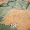
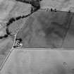
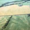
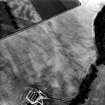
Ballownie NO 609 654 NO66NW 47
Cropmarks reveal a possible unenclosed settlement 250m NNW of Ballownie Cottages. There are up to five irregular linear features and at least one crescentic structure, the former possibly indicating the presence of souterrain like structures. A second crescentic cropmark is situated 80m to the E (NO 610 654), and a third 140m to the NNE (NO 610 655).
RCAHMS 1983.

