
Tornagrain, Morayston


Pottery Kiln(S) (Prehistoric)(Possible), Pottery Manufacturing Site (Prehistoric)(Possible), Roundhouse(S) (Prehistoric), Settlement (Prehistoric), Structure(S) (Prehistoric), Arrowhead(S) (Prehistoric), Organic Material (Bone)(Prehistoric), Organic Material (Wood)(Prehistoric), Saddle Quern(S) (Prehistoric), Unidentified Pottery(S) (Prehistoric)
Site Name Tornagrain, Morayston
Classification Pottery Kiln(S) (Prehistoric)(Possible), Pottery Manufacturing Site (Prehistoric)(Possible), Roundhouse(S) (Prehistoric), Settlement (Prehistoric), Structure(S) (Prehistoric), Arrowhead(S) (Prehistoric), Organic Material (Bone)(Prehistoric), Organic Material (Wood)(Prehistoric), Saddle Quern(S) (Prehistoric), Unidentified Pottery(S) (Prehistoric)
Canmore ID 358442
Site Number NH74NW 152
NGR NH 7496 4944
Datum OSGB36 - NGR
Permalink http://canmore.org.uk/site/358442


- Council Highland
- Parish Petty
- Former Region Highland
- Former District Inverness
- Former County Inverness-shire
Excavation (November 2015 - April 2016)
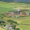
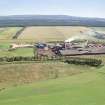
NH 7496 4944 A programme of archaeological work was undertaken, November 2015 – April 2016, prior to the construction of a bio-gas plant at Morayston. A total of 466 truncated archaeological features were identified across the site, all cut into the natural sand and located in two distinct areas.
Area 1 was located at the W side of the site close to the unnamed road joining the B9039 and the A96. This contained 42 features including a series of well-defined pits, the majority of which contained significant amounts of charred plant material, mostly charcoal, and unabraded pottery sherds in either primary or stratigraphically earlier fill deposits. In view of these shared characteristics of in situ burning and the presence of primary pottery sherds the features were described as pit-kilns and are provisionally interpreted to reflect activity associated with prehistoric pottery production. There were a total of 19 of these features which were subdivided into two principal groups, each group dominated by a complex arrangement of intercutting pits.
Area 2 was opened at the E end of the site, closer to the ‘Rough Burn’. This large area revealed >270 features, several of which clearly represented either parts of or complete earthfast timber structures. In addition, there were a large number of isolated features, the majority representing postholes, for which it was not possible in many cases to assign function or structures. The majority of classifiable features are provisionally dated to the prehistoric period. The
principal archaeology identified at the E end included the remains of four classic timber roundhouse structures.
Structure A was heavily truncated but tentatively interpreted as a possible roundhouse with just four surviving postholes on the SW side of the post ring and a possible porch to the SW.
Roundhouse B consisted of a clear ring of nine posts with post packing and a porch to the SE.
Roundhouses C and D overlapped each other but without intercutting postholes, so their chronological sequence could not be ascertained stratigraphically.
No ring ditches were present in any of the roundhouses. This may be due to the generally truncated nature of the site, or because they had never been present.
Three four-post timber structures were also found in the vicinity of the roundhouses, two of which appear to have had extensions or ancillary structures in the SW, although the precise meaning of these arrangements are unclear at present.
Artefacts recovered include flint arrowheads and thumbscrapers, stone tools including five saddle querns, a substantial assemblage of prehistoric pottery sherds and small amounts of burnt or cremated bone. A large piece of charred wood was tentatively interpreted as a deliberately placed domestic object.
Archive: Highland HER and NRHE
Funder: Tornagrain Gas Mill
Lynne McKeggie and Lachlan McKeggie – Highland Archaeology Services
(Source: DES, Volume 18)

