
Red Castle


Barrow(S) (Prehistoric), Square Barrow(S) (Iron Age)
Site Name Red Castle
Classification Barrow(S) (Prehistoric), Square Barrow(S) (Iron Age)
Alternative Name(s) Redcastle
Canmore ID 35800
Site Number NO65SE 18
NGR NO 6878 5085
NGR Description Centred at NO 6878 5085
Datum OSGB36 - NGR
Permalink http://canmore.org.uk/site/35800


- Council Angus
- Parish Inverkeilor
- Former Region Tayside
- Former District Angus
- Former County Angus
(Location cited as NO 686 508). Redcastle, square barrows/ring ditches, excavations. AAS/97/11/G22/26, 29 and 30; AAS/97/11/G23/1-10; AAS/97/11/CT.
NMRS, MS/712/29
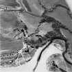
NO 6878 5085 The cropmarks of a barrow cemetery and settlement are visible in the field to the S of Red Castle. Excavation of the E part of this cropmark complex was undertaken as part of Edinburgh University's Angus and South Aberdeenshire Field School. A trench measuring 60 x 30m was topsoiled and revealed the remains of the ditches of at least five square barrows, one further possible square barrow, two round barrows and two unenclosed burials. In addition to these burials, other features excavated included a series of isolated pits and part of a souterrain.
Each of the square barrows contained a central burial surrounded by four ditches with breaks at the corners. The square barrows ranged in size from 7-10m across. The degree of preservation of the ditches varied greatly. The largest and best-preserved barrow at the NE limit of the excavation had ditches up to 0.3m deep. In general, however, the rest of the ditches were relatively shallow and poorly preserved. The upper fill of the ditches of the two largest square barrows contained beach/river pebbles that had either been placed along the line of the ditch or had fallen in from the gradual decay of an accompanying cairn or bank, perhaps accelerated by ploughing. The two round barrows were approximately 8.5m in diameter; one had a slightly deeper ditch. Ten burials were excavated. All were extended inhumations within long graves aligned approximately SW-NE with the heads at the SW end. The majority of the burials were set within long cists constructed from locally available red sandstone and were covered by capstones. The only exception was in one of the square barrow graves where an organic stain represented the remains of a timber or leather coffin. The preservation of human remains varied greatly between the graves with most containing a body stain, fragments of teeth, skull and long bones. The best-preserved human remains were recovered from the largest square barrow which also had the deepest central grave. None of the burials contained grave goods. In at least two of the square barrows the graves were aligned obliquely to the barrow ditches.
The partially examined souterrain at the northern end of the site consisted of a narrow, shallow curvilinear entrance passage leading into a deeper central passage, only part of which was excavated. This souterrain was cut into natural sand and gravel subsoil and lacked stone revetting. The curvilinear entrance passage was c 6.5m long, 0.8-0.9m wide and 0.5m deep. Its fill contained lumps of clay, possibly daub, and fragments of charcoal, suggesting that the sides may have been lined with wattle and daub. About 1m from the junction of the entrance passage with the main souterrain, two post-holes perhaps marked the position of a timber doorway. The main souterrain passage was 1.5m wide and 1.4m deep. A total length of 3m was excavated but this feature clearly continued to the E and W. The lower fill was a deep deposit of silty sand within which numerous carbonised cereal grains were distributed. It appears that the souterrain was deliberately backfilled and from these deposits came a number of sherds of pottery, fragments of sheet bronze, and shards of glass.
Isolated pits were found scattered across the site and artefacts were recovered from a number of them. An elongated pit close to the entrance to the souterrain contained numerous burnt and cracked stones and two stone lamps (one decorated). Three other pits contained sherds of Late Neolithic Grooved Ware and one contained a sherd of Impressed Ware.
Geophysical survey and fieldwalking in the area to the W of the excavation proved relatively unproductive. Trial trenching of 600m2 in the rest of the field appeared to confirm the aerial photographic evidence that the archaeological features were focused in the N.
Sponsors: Historic Scotland, Edinburgh University.
D Alexander and A Rees 1997.
NO 6878 5085 A second season of excavation was carried out on the cropmarks in the field to the S of Red Castle (NMRS NO65SE 18 and NO65SE 19 ). A trench was topsoiled immediately to the N of the area excavated last year (Alexander and Rees 1997) and focused on the remains of a souterrain, of which a side entrance and part of the main passage had been investigated.
The remainder of the fill of the souterrain was completely removed. It was entered through a gently sloping, curving passage from the NW, which contained a layer of clay immediately above its floor, possibly collapsed daub. Artefacts recovered from this entrance area include a large iron handle (possibly from a bucket) and shards from a Roman glass vessel. About 3.8m from the entrance there was a marked step down into the deeper part of the souterrain. This step was flanked by two large posts probably marking a doorway. The souterrain then turned sharply W into the main passage which curved slightly to the NW. This component was approximately 12m long, 1.5m wide and up to 1.4m deep. There were at least four pairs of post-holes along the main part of the passage which appear to have held wood revetting the sides; there was no stone lining. No remains of any above-ground timber structures associated with the souterrain were recovered.
Six burials were also located. Four of these were in sandstone long cists and skeletal material survived in various states of preservation. The other two burials were unlined extended inhumations and only body stains survived. A number of lengths of shallow ditches, possibly the remains of barrows surrounding some of these burials, were identified, along with a scatter of pits, one of which produced a lozenge-shaped flint arrowhead.
A detailed report will be lodged with the NMRS.
Sponsors: Historic Scotland, University of Edinburgh.
D Alexander 1998
Project (1 June 1976 - 31 August 1976)
On the recommendation of the Committee for Rescue Archaeology set up by the Scottish Ancient Monuments Board a grant was made to the Commission in 1976 to allow it to carry out an extensive aerial survey programme. Climatic conditions during the period June-August were exceptionally favourable in much of eastern Scotland and more than 600 monuments were recorded, the majority being identified by means of crop-markings, a large number of which were new discoveries. The most interesting sites included Dark Age or Medieval timber halls on Deeside (NO 737967 [NO79NW 18], 733959 [NO79NW 16]) and west of Brechin (NO 509585 [NO55NW 40]); new Roman temporary camps at Ford, Midlothian (NT 384638 [NT36SE 18]) and Millside Wood [sic], Roxburghshire (NT 690270); double pit-alignments at Kinnell and Kinalty, Angus (NO 605494 [NO64NW 27], 356512 [NO35SE 32]); and a number of small, square-ditched enclosures, possibly barrows of the later Iron Age, in the Lunan valley, Angus (NO 626491 [NO64NW 95], 618494 [NO64NW 41] and 687509 [NO65SE 18]). A summary list of all these sites has been compiled and the prints will shortly be available for inspection in the National Monuments Record of Scotland.
RCAHMS (DES 1976, 84)
Field Visit (March 1978)
Red Castle NO 687 509 NO65SE
Crop-marks showing the ditches of at least one square and two circular barrows have been located in a field S of Red Castle, on the edge of the raised beach. The square barrow measures about 5m square within the ditch, which appears to be broken by causeways at the corners; the larger of the circular barrows measures about 10m in diameter over all.
RCAHMS 1978, visited March 1978
Aerial Photographic Transcription (11 May 1995 - 11 December 1995)
An aerial transcription was produced from oblique aerial photographs. Information from Historic Environment Scotland (BM) 31 March 2017.
Unspecified Geophysical Survey Technique (1997)
Geophysical survey proved unproductive at Red Castle, Lunan Bay as part of the Edinburgh University's Angus and South Aberdeenshire Field School.
Excavation (1997 - 1998)
Excavation of a cropmark barrow cemetery and settlement at Red Castle, Lunan Bay by CFA as part of the Edinburgh University's Angus and South Aberdeenshire Field School.
NO 6878 5085 The cropmarks of a barrow cemetery and settlement are visible in the field to the S of Red Castle. Excavation of the E part of this cropmark complex was undertaken as part of Edinburgh University's Angus and South Aberdeenshire Field School. A trench measuring 60 x 30m was topsoiled and revealed the remains of the ditches of at least five square barrows, one further possible square barrow, two round barrows and two unenclosed burials. In addition to these burials, other features excavated included a series of isolated pits and part of a souterrain.
Each of the square barrows contained a central burial surrounded by four ditches with breaks at the corners. The square barrows ranged in size from 7-10m across. The degree of preservation of the ditches varied greatly. The largest and best-preserved barrow at the NE limit of the excavation had ditches up to 0.3m deep. In general, however, the rest of the ditches were relatively shallow and poorly preserved. The upper fill of the ditches of the two largest square barrows contained beach/river pebbles that had either been placed along the line of the ditch or had fallen in from the gradual decay of an accompanying cairn or bank, perhaps accelerated by ploughing. The two round barrows were approximately 8.5m in diameter; one had a slightly deeper ditch. Ten burials were excavated. All were extended inhumations within long graves aligned approximately SW-NE with the heads at the SW end. The majority of the burials were set within long cists constructed from locally available red sandstone and were covered by capstones. The only exception was in one of the square barrow graves where an organic stain represented the remains of a timber or leather coffin. The preservation of human remains varied greatly between the graves with most containing a body stain, fragments of teeth, skull and long bones. The best-preserved human remains were recovered from the largest square barrow which also had the deepest central grave. None of the burials contained grave goods. In at least two of the square barrows the graves were aligned obliquely to the barrow ditches.
The partially examined souterrain at the northern end of the site consisted of a narrow, shallow curvilinear entrance passage leading into a deeper central passage, only part of which was excavated. This souterrain was cut into natural sand and gravel subsoil and lacked stone revetting. The curvilinear entrance passage was c 6.5m long, 0.8-0.9m wide and 0.5m deep. Its fill contained lumps of clay, possibly daub, and fragments of charcoal, suggesting that the sides may have been lined with wattle and daub. About 1m from the junction of the entrance passage with the main souterrain, two post-holes perhaps marked the position of a timber doorway. The main souterrain passage was 1.5m wide and 1.4m deep. A total length of 3m was excavated but this feature clearly continued to the E and W. The lower fill was a deep deposit of silty sand within which numerous carbonised cereal grains were distributed. It appears that the souterrain was deliberately backfilled and from these deposits came a number of sherds of pottery, fragments of sheet bronze, and shards of glass.
Isolated pits were found scattered across the site and artefacts were recovered from a number of them. An elongated pit close to the entrance to the souterrain contained numerous burnt and cracked stones and two stone lamps (one decorated). Three other pits contained sherds of Late Neolithic Grooved Ware and one contained a sherd of Impressed Ware.
Geophysical survey and fieldwalking in the area to the W of the excavation proved relatively unproductive. Trial trenching of 600m2 in the rest of the field appeared to confirm the aerial photographic evidence that the archaeological features were focused in the N.
Sponsors: Historic Scotland, Edinburgh University.
D Alexander and A Rees 1997.
NO 6878 5085 A second season of excavation was carried out on the cropmarks in the field to the S of Red Castle (NMRS NO 65 SE 18, 19). A trench was topsoiled immediately to the N of the area excavated last year (Alexander and Rees 1997) and focused on the remains of a souterrain, of which a side entrance and part of the main passage had been investigated.
The remainder of the fill of the souterrain was completely removed. It was entered through a gently sloping, curving passage from the NW, which contained a layer of clay immediately above its floor, possibly collapsed daub. Artefacts recovered from this entrance area include a large iron handle (possibly from a bucket) and shards from a Roman glass vessel. About 3.8m from the entrance there was a marked step down into the deeper part of the souterrain. This step was flanked by two large posts probably marking a doorway. The souterrain then turned sharply W into the main passage which curved slightly to the NW. This component was approximately 12m long, 1.5m wide and up to 1.4m deep. There were at least four pairs of post-holes along the main part of the passage which appear to have held wood revetting the sides; there was no stone lining. No remains of any above-ground timber structures associated with the souterrain were recovered.
Six burials were also located. Four of these were in sandstone long cists and skeletal material survived in various states of preservation. The other two burials were unlined extended inhumations and only body stains survived. A number of lengths of shallow ditches, possibly the remains of barrows surrounding some of these burials, were identified, along with a scatter of pits, one of which produced a lozenge-shaped flint arrowhead.
A detailed report will be lodged with the NMRS.
Sponsors: Historic Scotland, University of Edinburgh.
D Alexander 1998

