
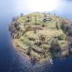
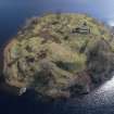
Eilean Fhianain, North West Platforms


Grave Marker(S) (Period Unassigned), Platform(S) (Period Unassigned), Slag (Period Unassigned)
Site Name Eilean Fhianain, North West Platforms
Classification Grave Marker(S) (Period Unassigned), Platform(S) (Period Unassigned), Slag (Period Unassigned)
Canmore ID 356247
Site Number NM76NE 1.17
NGR NM 75191 68346
Datum OSGB36 - NGR
Permalink http://canmore.org.uk/site/356247


- Council Highland
- Parish Arisaig And Moidart
- Former Region Highland
- Former District Lochaber
- Former County Inverness-shire
Field Visit (5 September 2017)
This group of at least 15 platforms is located along the NW and N coast of Eilean Fhianain. The majority appear to be related to the use of the island as a burial place, and in particular to the need for soil from borrow pits, and a need to create discrete areas for burials in a relatively recent period. That said, the presence of slag, charcoal and a fragment of iron indicate the possibility that some were also used for the purposes of small industry.
1. NM 75213 68349: This grass-grown platform, which is cut back into the steeply rising slope on the N side of the island, measures 13.7 from E to W by 6m transversely, with a rear scarp up to 2.5m high and a frontal apron up to 0.7m high. A small fragment of iron slag was noted in a disturbed area at the W end.
2. NM 75204 68342: This grass-grown platform, which is cut back into the steeply rising slope on the N side of the island, measures 8.3m from NE to SW by 7.1m transversely, with a rear scarp up to 0.6m high and a frontal apron up to 0.3m high.
3. NM 75210 68340: This grass-grown platform, which is cut back into the steeply rising slope on the N side of the island, measures 4.8m from E to W by 5.3m transversely, with a rear scarp up to 0.5m high. It is occupied by what appears to be a grave orientated from N to S, in addition to a scatter of rubble.
4. NM 75221 68340: This grass-grown platform, which is cut back into the steeply rising slope on the N side of the island, measures 7.4m square, with a rear scarp up to 2m high. It is occupied by at least three small stone grave-markers. Charcoal occurs on the N facing scarp below.
5. NM 75231 68337: This grass and reed grown platform, which is cut back into the steeply rising slope on the N side of the island, measures 7m from E to W by 6m transversely, with a rear scarp up to 1.2m high. It is occupied by at least four small stone grave-markers and a scatter of stone derived from a small cairn. Charcoal occurs on the N facing scarp below.
6. NM 75234 68342: This grass-grown hollow, which is cut back into the steeply rising slope on the N side of the island, measures 4.3m from E to W by 5m transversely, with a rear scarp 1m high. Two tall European Larch stand on its N and another on its SW edge.
7. NM 75227 68348: This grass-grown platform, which is cut back into the steeply rising slope on the N side of the island, measures 8m from E to W by 6.8m transversely, with a rear scarp 0.7m high. Six tall European Larch stand on its N scarp, while a fragment of iron was noted on the scarp below.
8. NM 75240 68344: This grass-grown platform, which is cut back into the steeply rising slope on the N side of the island, measures 7.4m from E to W by 6m transversely, with a rear scarp 0.4m high and a frontal apron up to 0.5m high. It is occupied by a small scatter of stones marking a possible grave and a small stone grave-marker. In addition, there are traces of what may be a hut measuring 2.1m from N to S by 1.3m transversely, within spread turf walls 0.8m thick and up to 0.15m high.
11. NM 75245 68350: This grass and reed-grown platform, which is cut back into the steeply rising slope on the N side of the island, measures 6.5m from E to W by 5.2m transversely, with a rear scarp 0.6m high.
12. NM 75230 68373: This grass-grown platform, which is cut back into the steeply rising slope on the N side of the island, measures 8m from E to W by 4m transversely, with a rear scarp 1.5m high.
37. NM 75169 68286: This grass-grown platform, which is cut back into the steeply rising slope on the WNW side of the island, measures 5.5m from NE to SW by 4.8m transversely, with a rear scarp 1m high.
38. NM 75167 68296: This grass, reed, fern and alder-grown platform, which is cut back into the steeply rising slope on the WNW side of the island, measures 7.5m from NNE to SSW by 4.6m transversely, with a rear scarp 1m high.
39. NM 75176 68304: This grass, fern and larch-grown platform, which is cut back into the steeply rising slope on the NW side of the island, measures 17.5m from NE to SW by 8.7m transversely, with a rear scarp 0.8m high. It is occupied by a small cairn at its leading edge.
40. NM 75173 68312: This waterlogged, grass, reed, fern and alder-grown platform, which is cut back into the steeply rising slope on the NW side of the island, measures 11m from NE to SW by 4m transversely, with a rear scarp 0.6m high.
41. NM 75189 68329: This waterlogged, grass and reed-grown platform, which is cut back into the steeply rising slope on the NW side of the island, measures 8m from NNE to SSW by 7m transversely, with a rear scarp 1m high.
Visited by HES, Archaeological Survey (ATW, GFG) 5 September 2017

