
Pricing Change
New pricing for orders of material from this site will come into place shortly. Charges for supply of digital images, digitisation on demand, prints and licensing will be altered.
Ardross Castle


Castle (Medieval)
Site Name Ardross Castle
Classification Castle (Medieval)
Canmore ID 34201
Site Number NO50SW 15
NGR NO 50842 00687
Datum OSGB36 - NGR
Permalink http://canmore.org.uk/site/34201


- Council Fife
- Parish Elie
- Former Region Fife
- Former District North East Fife
- Former County Fife
NO50SW 15 50842 00687
(NO 5084 0070) Ardross Castle (NR)
(Remains of)
OS 6" map (1938).
Location formerly entered as NO 5084 0070.
For (presumably-associated) dovecot (NO 50763 00753), see NO50SW 16.
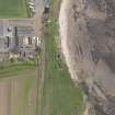
The remains of Ardross Castle, consisting of two very ruinous rectangular structures contiguous to each other, stand 1 mile E of Elie on the raised beach 40' above the shore.
The N structure is possibly 15th century and the earlier of the two. It has been excavated, revealing a small tower, 28 3/4' N-S by 36 3/4' E-W over walls in excess of 6' thick. The entrance is in the S gable. There has been a small building against the N gable.
The second structure measures 78' N-S by 19' E-W within walls 6' thick. It lies to the S of the tower and is attached to it by the remains of a short wall. At the SE angle there may have been a circled stair tower. William Dishington, son of the Sir William who died c.1360, doubtless built Ardross Castle.
W Wood 1887; RCAHMS 1933.
The remains of the castle are as described.
Revised at 25".
Visited by OS (DWR) 29 May 1974.
Ardross Castle [NAR]
(remains of) [NAT]
OS (GIS) MasterMap, October 2010.
Reference (24 February 1853)
The ruins of an old castle situated on the top of a steep bank close by the high water mark on the farm of Ardross and consisting of the remains of the outside wall which is about 7 feet height and about 5 feet in thickness, it appears to have been about 90 to 100 foot long by about 35 foot wide. Of its origin or the date of its erection nothing is locally known further than that it was at one time the baronial residence of former proprietors. Informant William Given says that it belonged at one time to a family of the name 'Scott', and before that to a family of the name 'Dischington' and that he read such account in the History of Fife by Leighton (v.III, p87). Latterly it was with other hands in the vicinity the property of Sir William C Anstruther. It is now the property of Mr Baird. The period at which it became a ruin as well as the date of erection is unknown.
Ordnance Survey Name Book, Fife, Book 80, 117. Entry by Thomas Smith 24th February 1853.
References: Rev Mr Page (Parish Minister), William Girvan (mason), George Forgan (farmer).
Entered by RCAHMS (GFG) 11 October 2012
Field Visit (21 July 1927)
The remains of Ardross Castle stand one mile eastward of Elie on the raised beach, which at this part is some 40 feet above the present shore. They consist mainly of two very ruinous rectangular structures contiguous to each other. The northern structure, which is the earlier of the two, has been excavated, revealing the lower part of the ground floor of a small tower of possibly the 15th century, which measures 28 ¾ feet from north to south by 36 ¾ feet from east to west, over walls 6 feet 3 inches to 6 feet 10 inches in thickness. The entrance, which had a broad splay on the jambs, is in the southern gable. It forms a mural lobby with a mural staircase on the western and left-hand side. The lowest steps of the stair are straight, but the upper part is a turnpike, possibly an insertion. Proceeding northwards through the lobby, one finds oneself in what has been a vaulted chamber, measuring 16 ¼ feet by 23 ¼ feet, with a window looking eastward and only 5 ½ inches in width. The scontions of this window converge as they rise to suit a short lintel. There has been another window in the northern gable at a higher level. Each gable contains an aumbry. On the west are the remains of a service-stair which presumably rose from ground-floor to Hall. A small building with a heavy north wall has been reared against the north gable. The second structure, which measures 78 feet from north to south by 19 feet from east to west within walls about 6 feet in thickness, lies to the south of the tower and is attached to it by the remains of a short wall. It as not been vaulted. There appear to have been six openings towards the sea, but it is no longer possible to say whether they have been windows or doors. At the south-east angle there may have been a circular stair-tower.
Dovecot (NO50SW 16) – Beside the high road, 100 yards north-west of the Castle, is a 17th century dovecot oblong on plan, built of rubble, harled, and measuring 13 feet 10 inches by 24 ½ feet.
Historical Note – in 1402 the king granted to Thomas de Dischington the lands of the barony of Ardross, which is father William de Dischington had resigned. This family possessed Ardross for the next two hundred years. But in 1607, Thomas Dischington sold to William Scot of Elie and his heirs ‘the lands and barony of Ardoss with the fortalice and manor-place’ (Reg. Mag. Sig., s.a, p.651). Towards the close of the 17th century the lands were acquired by Sir William Anstruther of that ilk (Ibid, s.a., No. 1899).
Visited by RCAHMS 21 July 1927
Field Visit (21 July 1927)
Ardross Castle.
The remains of Ardross Castle stand one mile eastward of Elie on the raised beach, which at this part is some 40 feet above the present shore. They consist mainly of two very ruinous rectangular structures contiguous to each other. The northern structure, which is the earlier of the two, has been excavated, revealing the lower part of the ground floor of a small tower of possibly the 15th century, which measures 28 ¾ feet from north to south by 36 ¾ feet from east to west, over walls 6 feet 3 inches to 6 feet 10 inches in thickness. The entrance, which had a broad splay on the jambs, is in the southern gable. It forms a mural lobby with a mural staircase on the western or left-hand side. The lowest steps of the stair are straight, but the upperpart is a turnpike, possibly an insertion. Proceeding northwards through the lobby, one finds oneself in what has been a vaulted chamber, measuring 16 ¼ by 23 ¼ feet, with a window looking eastward and only 5 ½ inches in width. The scontions of this window converge as they rise, to suit a short lintel. There has been another window in the northern gable at a higher level. Each gable contains an aumbry. On the west are the remains of a service-stair which presumably rose from ground-floor to Hall. A small building with a heavy north wall has been reared against the north gable. The second structure, which measures 78 feet from north to south by 19 feet from east to west within walls about 6 feet in thickness, lies to the south of the tower and is attached to it by the remains of a short wall. It has not been vaulted. There appear to have been six openings towards the sea, but it is no longer possible to say whether they have been windows or doors. At the south-east angle there may have been a circled stair-tower.
HISTORICAL NOTE. In 1402 the king granted to Thomas de Dischington the lands of the barony of Ardross, which his father William de Dischington had resigned (1). This family possessed Ardross for the next two hundred years. But in 1607, Thomas Dischington sold to William Scot of Elie and his heirs "the lands and barony of Ardross with the fortalice and manor-place” (2). Towards the close of the 17th century the lands were acquired by Sir William Anstruther of that ilk.
RCAHMS 1933, visited 21 July 1927.
(1) Reg. Mag. Sig., s.a., p. 651. (2) Ibid., s.a., No. 1899.
Desk Based Assessment (21 January 1963)
(NO 5084 0070) Ardross Castle (NR)
(Remains of)
OS 6" map (1938).
The remains of Ardross Castle, consisting of two very ruinous rectangular structures contiguous to each other, stand 1 mile E of Elie on the raised beach 40' above the shore.
The N structure is possibly 15th century and the earlier of the two. It has been excavated, revealing a small tower, 28 3/4' N-S by 36 3/4' E-W over walls in excess of 6' thick. The entrance is in the S gable. There has been a small building against the N gable.
The second structure measures 78' N-S by 19' E-W within walls 6' thick. It lies to the S of the tower and is attached to it by the remains of a short wall. At the SE angle there may have been a circled stair tower. William Dishington, son of the Sir William who died c.1360, doubtless built Ardross Castle.
Information from OS (DT) 21 January 1963
W Wood 1887; RCAHMS 1933.
Field Visit (29 May 1974)
The remains of the castle are as described.
Revised at 25".
Visited by OS (DWR) 29 May 1974.
Photo (from SW) attached to record card.
Field Visit (10 October 2011)
The remains of Ardross Castle stand immediately to the south of both Ardross farmstead and the route of the ‘Leven and East of Fife Railway’, which operated between the 1850s and 1960s. A detailed architectural description was prepared in 1927 (RCAHMS 1933, 134) to which can be added the following notes.
The excavation of the ‘small tower’ probably occurred between surveys of 1893 and 1912 judging from the different level of detail shown on two OS 25-inch maps (Fife and Kinross, Sheet XXX.NW, 1896 and 1919). This involved the removal of material from the interior and also the clearance of material from the outer face of the walls. The spoil from these excavations forms a prominent bank immediately NW of the tower. As noted in 1927, the entrance and stair in the SW gable have been remodelled. There is also one moulded jamb stone in situ on the NW side of the doorway. The ‘small building with a heavy north wall that has been reared against the north [NE] gable’ measures about 8m square over a stone wall about 0.8m in thickness and up to 0.8m in height. Three of the six openings in the SE wall of the ‘second structure’ retain similar relieving arches and are probably window openings. The opening at the SW end of this wall has led into a small building that may well have held a turnpike stair. Contra RCAHMS 1933, the second structure may have been vaulted as elements of masonry at first floor level appear to extend beyond the inner facing stones.
Most of the facing stones of the SW building have been robbed leaving only the core visible (the NE tower may have been rendered inaccessible to stone-robbers by the build up of material around it before excavation). Similar stone is visible in the farmsteading buildings nearby.
The 1st edition of the OS 6-inch map (Fife, Sheet 26, 1855) shows an enclosure to the SW of the castle, but this was not visible on the date of visit. As depicted on that map, it measured about 24m from NE to SW by 22m transversely.
Visited by RCAHMS (GFG, AGCH) 10 October 2011

