
Following the launch of trove.scot in February 2025 we are now planning the retiral of some of our webservices. Canmore will be switched off on 24th June 2025. Information about the closure can be found on the HES website: Retiral of HES web services | Historic Environment Scotland
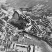
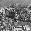
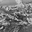
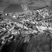
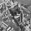
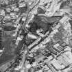
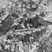
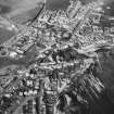
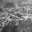
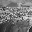
Anstruther Wester Harbour


Harbour (Period Unassigned)
Site Name Anstruther Wester Harbour
Classification Harbour (Period Unassigned)
Alternative Name(s) Dreel Burn; Firth Of Forth; Outer Forth Estuary
Canmore ID 34183
Site Number NO50SE 49
NGR NO 565 035
Datum OSGB36 - NGR
Permalink http://canmore.org.uk/site/34183


- Council Fife
- Parish Anstruther Wester
- Former Region Fife
- Former District North East Fife
- Former County Fife
NO50SE 49 565 035
For Anstruther Easter Harbour (NO 568 034), see NO50SE 48.00.
(Location cited as NO 564 035). This harbour occupied the mouth of the Dreel Burn which separates the two Anstruther burghs and debouches into the W end of the bay in front of Anstruther Wester's quay. The burn-mouth was evidently serving both communities as early as 1225, and in all probability had done so since the earliest times, but modern conditions associate it with Anstruther Wester. There is no question of artificial harbour-works as early as the 13th century, as the document referred to states that ships and fishing-boats were fixing their anchors on a beach. The earliest hint of structure comes only in 1604 with a reference to the 'burn, port and haven', but as the harbour needed repair in 1613, for which it secured a grant of ?200 in 1620, it it is unlikely to have been built later than, say, the 1580's as some time would be necessary for dilapidation to proceed, failing some sudden disaster. In 1620 it could accommodate a ship of size to trade with the Baltic, but later it fell on evil times. In 1661 the burgh reported the loss of of its trade and all its shipping, apparently as a result of the Civil War, and gave up its burghal privileges in 1670.
Sibbald's editor further states that two inundations of the later 17th century 'destroyed or choked up the harbour, washed away the bulwarks and swept off a long street', one of them probably having been the great storm of 1655. Wood dates the choking of the harbour and the destruction of the 'bulwarks' to 1670, but it is disquieting to find him going on to state that the 'fore-street' and the harbour were carried away in the second half of the 18th century, as if everything had been misdated by a hundred years. If such a confusion is suspected, the 1670 date is probably to be preferred as the harbour was largely ruinous in 1703. The port, however, cannot have gone completely out of business, as dues were being charged in 1695 and 'Sea Box' papers exist for the years 1659-1720. In 1710 the harbour was described as 'mean and inconveneint'.
As might be expected in view of its disastrous history, the place now holds little of archaeological interest. All that survives is a quay, reconstructed as a car park, which flanks the burn-mouth on the S and measures about 150 ft (45.7m) by 60 ft (18.3m). Its face is of well dressed blocks set vertically; these are probably old material but their regularity suggests that the face has been rebuilt. A flight of steps which descends through the face may or may not be original, while the parapet, which extends to the adjoining stretch of frontage, shows every sign of reconstruction. The 'long street' that Sibbald's editor records as having been washed away was most probably a southward extension of this frontage, as it now ends blind on rocks about 90ft (27.4m) from the quay. Crichton Street and the next street to the S of it likewise end blind on the same stretch of rocks, in a way which would agree with some 400 ft (122m) or more of roadway and houses having been carried away.
A Graham 1971.

