
Pricing Change
New pricing for orders of material from this site will come into place shortly. Charges for supply of digital images, digitisation on demand, prints and licensing will be altered.
Sanday, Augmund Howe West


Bank (Earthwork) (Bronze Age), Barrow(S) (Bronze Age), Cist(S) (Bronze Age), Inhumation(S) (Bronze Age)
Site Name Sanday, Augmund Howe West
Classification Bank (Earthwork) (Bronze Age), Barrow(S) (Bronze Age), Cist(S) (Bronze Age), Inhumation(S) (Bronze Age)
Alternative Name(s) Elsness; Egmondshowe
Canmore ID 3409
Site Number HY63NE 5
NGR HY 67550 37530
NGR Description From HY 67601 37423 to HY 67619 37574
Datum OSGB36 - NGR
Permalink http://canmore.org.uk/site/3409


- Council Orkney Islands
- Parish Lady
- Former Region Orkney Islands Area
- Former District Orkney
- Former County Orkney
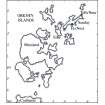
HY63NE 5 c. 676 375.
See also HY63NE 6 and HY63NE 13.
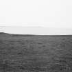
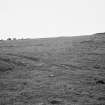
(Area: HY 676 375) A series of small mounds, apparently connected by a low ridge, and covered by turf, lie close to the west side of HY63NE 3 and follow a sinuous course round it.
Ten mounds were counted at intervals along the line but neither the nature of the mounds nor the meaning of their arrangement can be determined without excavation.
RCAHMS 1946, visited 1935.
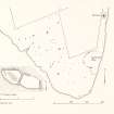
In the area centred at HY 676 375 are eleven turf-covered cairns, connected by a turf-covered stony bank, which form an arc around the remains of a large cairn (HY63NE 3) with which they are probably contemporary (one of which was partly excavated by the section revealing two con-joined shortcists each covered by capstones, and formed with built walling on the N and S sides and slabs at the E and W ends, with a slab separating the two cists. Some human bones were found within each cist, but the excavation was abandoned in order to preserve the site.) The cairns vary in size from c5.0m to c10.0m in diameter, and 0.5m to 0.6m in height, and in shape from circular to oval.
The interconnecting bank is spread to c2.0m, and survives to a maximum height of 0.3m. It probably once completely enclosed the cairn (HY63NE 3) but the east side is destroyed by erosion. Towards the N end of the enclosed area are the vague turf-covered footings of a rectangular structure with rounded corners, measuring c8.0m by c3.5m. Its purpose cannot be ascertained.
(For a similar association of large cairn surrounded by smaller cairns and interconnecting bank - see HY45SE19.)
Surveyed at 1/2500.
Visited by OS(NKB) 7 July 1970.
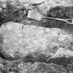
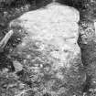
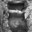
With the object of determining its nature, an exploratory excavation was made into one of these mounds ('A' on plan) by the section with the assistance of Mr R Seatter, of Elsness on 7th and 8th July 1970. The mound was heavily turfed and spread to about 10.0m in diameter with a maximum height of 0.6m, and its surface, although disturbed probably by digging out rabbits, showed no sign of stones. The centre was dug into revealing a content of earth and flat stones apparently laid with a tiled effect evident in the eroded cairn (HY63NE 3). At a depth of c0.4m a roughly rectangular prostrate slab was encountered. It was oriented WNW-ESE and measured 2.5m by 1.1m by 0.1m thick, and proved to be the more easterly of two capstones covering a chamber forming an unusual double cist. The W capstone was a smaller slab which was not fully exposed and left undisturbed. When the main capstone was raised, the chamber oriented WNW-ESE and bisected by a transverse upright slab was revealed, each compartment being full of earth, and obviously never previously disturbed. In order to establish their constructional details both compartments were partially and carefully excavated. The more easterly, measuring 1.35m maximum length by 0.9m maximum width, proved to be full of dry hard packed earth with an admixture of slate-like chips. At a depth of 0.5m a human pelvic bone was exposed, but because of the difficult of removing the hard earth without damaging the bone the excavation of the compartment was abandoned. The position of the bone and the size of the cist suggested that the skeleton was crouched with its head to the W. The W compartment, measuring 1.25m max length by 0.9 m max width was then approached with the object of discovering its depth. The earth content was damp and much softer than in the other compartment, and was mixed with flat stones which had at one time probably fallen from the partly collapsed N wall and also flaked from the underside of the capstone. At a depth of 0.5m several human bones in disarray, some of them broken apparently by the fallen debris, were found with a mass of limpet shells. A fragment of undecorated coarse pottery blackened by fire was also amongst the shells. The remains were obviously in a poor state of preservation, after tracing the S wall to a depth of 0.9m, the excavation was abandoned.
The chamber was constructed of at least four upright slabs with the S side of both compartments being a curved slightly corbelled wall of small flat slabs roughly coursed, to a maximum of twelve courses in the W compartment. Part of the N wall of this compartment was also coursed, but had partly tumbled. Part of the N wall of the E compartment showed no retaining stonework at all.
The upright slab (marked 'X' on plan) at the W end of the W compartment was uncertainly part of the structure.
After planning the chamber it was covered with the pieces of the original capstone, which had unfortunately broken into three on being raised, and the excavation filled in.
Visited by OS(AA) 9 July 1970.
HY 676 375 (centre) EDM survey was undertaken at this site near Quoyness in September 1996. The site comprises a large field of 18 mounds (including NMRS HY63NE 3, HY63NE 5, HY63NE 6 ), and a chain of 11 mounds linked by a dyke which surround the probable chambered cairn at Egmondshowe. Since the survey was undertaken, the Scheduled area has been enlarged to take in the chain of mounds.
A survey report has been lodged with the NMRS.
Sponsor: Historic Scotland
J Downes 1998
Note (1980)
Egmondshowe, Eis Ness, Sanday HY c. 676 375 HY63NE 5
Eleven mounds connected by a bank forming an arc round the large cairn of Egmondshowe (HY63NE 3). One mound excavated by the Ordnance Survey contained two cists with human bones.
RCAHMS 1980
(RCAHMS 1946, ii, pp. 169-70, No. 451; OR 307)
Field Visit (31 August 1996)
These barrows were surveyed as part of the Orkney Barrows Project in September 1996, along with those called Elsness or Sivers Geo on the W side of the promontory.
The barrows are for the most part in good condition. With the linking earthen bank, this is a very substantial monument and a unique group. It should be noted that these are earthen barrows, not cairns, and should not be confused with stone-dyke-linking-cists feature as at Dennis Ness and Tor Ness.
Egmondshowe 1 (k): Diameter 9.0m. Height 0.35m.
Egmondshowe 2 (j): Measures 7.0m by 5.0m. Height 0.5-0.6m.
Egmondshowe 3 (i): Diameter 12.0m. Height 0.65m. Some slabs and uprights visible. This is the most prominent mound, visible from the W. It may be visible from the sea.
Egmondshowe 4 (h): Diameter 6.0m. Height 0.25m.
Egmondshowe 5 (g): Measures 13.0m by 9.0m. Height 0.6m. Stone uprights visible.
Egmondshowe 6 (f): Measures 11m NS by 7m EW. Height 0.4m.
Egmondshowe 7 (e): Measures 10m NS by 7m EW. Height 0.5m.
Egmondshowe 8 (d): Measures 11m EW by 6m NS. Height 0.2m.
Egmondshowe 9 (c): Measures 12m EW by 7m NS. Height 0.3m.
Egmondshowe 10 (b): Measures 10m EW by 7m NS. Height 0.3m. Some stones visible.
Egmondshowe 11 (a): Diameter 7.0m. Height 0.4m.
None of the mounds are prominent, but are probably visible from Tres Ness, 3.5km away.
Information from the Orkney Barrows Project (JD), 1996
Field Visit (1999)
A group of eleven small mounds, connected by a stony bank, surround the western side of the large damaged cairn of Augmund Howe (SY63; HY63NE3). One of the mounds, investigated by Ordnance Survey recorders, was found to contain two conjoined cists, each of which contained human bone. The cairns measure up to about 10m in diameter and are either circular or oval in shape. The site was most recently surveyed in 1996. Ref.: RCAHMS (1946) #451; RCAHMS (1980) #7; Downes, J (1998) 'Elsness, Sanday (Lady Parish)- survey of burial mounds' in DES 1998.
Coastal Zone Assessment Survey, 1999
Note (2020)
Egmondshowe
This burial site in Orkney Islands was a focus for funerary practices in the Bronze Age period, between 2450 BC and 801 BC.
Prehistoric Grave Goods project site ID: 60058
CANMORE ID: 3409
Total no. graves with grave goods: 1
Total no. people with grave goods: 2
Total no. grave goods: 2
Prehistoric Grave Goods project Grave ID: 60027
Grave type: Cist
Burial type(s): Inhumation, Inhumation
Grave good: Shell
Materials used: Coral/Shell [Shell]
Current museum location: Unknown
Grave good: Pot
Materials used: Pottery
Current museum location: Unknown
Further details, the full project database and downloads of project publications can be found here: https://doi.org/10.5284/1052206
An accessible visualisation of the database can be found here: http://blogs.reading.ac.uk/grave-goods/map/
Orkney Smr Note
'Mounds west of Augmund Howe'. The green sward close to and
west of Augmund Howe rises into a series of small elevations
apparently connected by a low ridge which follows a sinuous
course round the landward side of the Howe. Ten of these
elevations were counted along the line. [R1]
Information from Orkney SMR [n.d.]

