|
Prints and Drawings |
DC 17381 |
|
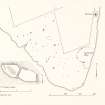
Plan of the Elsness area with detailed plan of cist from cairn B |
1981 |
Item Level |
|
|
Prints and Drawings |
DC 20100 |
Records of the Royal Commission on the Ancient and Historical Monuments of Scotland (RCAHMS), Edinbu |
Redrawn survey drawing at 1:2000; site plan of Elsness, Sanday indicating position of Quoyness chambered cairn and site to the S and W, covering an area of about 0.3 sq. kms. |
1981 |
Item Level |
|
|
Prints and Drawings |
DC 20101 |
Records of the Royal Commission on the Ancient and Historical Monuments of Scotland (RCAHMS), Edinbu |
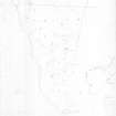
Survey drawing at 1:1000; site plan of Elsness, Sanday indicating position of Quoyness chambered cairn and sites to the S and W, covering an area of about 0.3 sq. km. |
5/8/1981 |
Item Level |
|
|
Photographs and Off-line Digital Images |
A 77364 |
Records of the Ordnance Survey, Southampton, Hampshire, England |
OS |
1970 |
Item Level |
|
|
Photographs and Off-line Digital Images |
A 77365 |
Records of the Ordnance Survey, Southampton, Hampshire, England |
OS |
1970 |
Item Level |
|
|
Photographs and Off-line Digital Images |
A 77367 |
Records of the Ordnance Survey, Southampton, Hampshire, England |
OS |
1970 |
Item Level |
|
|
Prints and Drawings |
DC 20097 |
Records of the Royal Commission on the Ancient and Historical Monuments of Scotland (RCAHMS), Edinbu |
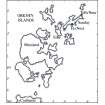
Location map showing the positions of Tofts Ness and Els Ness, Orkney. |
1980 |
Item Level |
|
|
Photographs and Off-line Digital Images |
O 1881 |
Papers of Dr Raymond G Lamb, archaeologist, Keith, Moray, Scotland |
R. Lamb |
1979 |
Item Level |
|
|
Photographs and Off-line Digital Images |
O 1882 |
Papers of Dr Raymond G Lamb, archaeologist, Keith, Moray, Scotland |
R. Lamb |
1979 |
Item Level |
|
|
Manuscripts |
MS 36/119 |
Records of the Royal Commission on the Ancient and Historical Monuments of Scotland (RCAHMS), Edinbu |
Field notebook of C S T Calder (RCAHMS). Titled 'Orkney'. |
27/6/1935 |
Item Level |
|
 |
On-line Digital Images |
DP 177055 |
|
Plan of the Elsness area with detailed plan of cist from cairn B |
1981 |
Item Level |
|
 |
On-line Digital Images |
SC 1817216 |
Records of the Royal Commission on the Ancient and Historical Monuments of Scotland (RCAHMS), Edinbu |
Location map showing the positions of Tofts Ness and Els Ness, Orkney. Scanned copy. |
1980 |
Item Level |
|
 |
On-line Digital Images |
SC 1817243 |
Records of the Royal Commission on the Ancient and Historical Monuments of Scotland (RCAHMS), Edinbu |
Survey drawing at 1:1000; site plan of Elsness, Sanday indicating position of Quoyness chambered cairn and sites to the S and W, covering an area of about 0.3 sq. km. |
5/8/1981 |
Item Level |
|
 |
On-line Digital Images |
SC 1923542 |
Papers of Dr Raymond G Lamb, archaeologist, Keith, Moray, Scotland |
R. Lamb |
1979 |
Item Level |
|
 |
On-line Digital Images |
SC 1923543 |
Papers of Dr Raymond G Lamb, archaeologist, Keith, Moray, Scotland |
R. Lamb |
1979 |
Item Level |
|
 |
On-line Digital Images |
SC 2243794 |
Records of the Ordnance Survey, Southampton, Hampshire, England |
OS |
1970 |
Item Level |
|
 |
On-line Digital Images |
SC 2243795 |
Records of the Ordnance Survey, Southampton, Hampshire, England |
OS |
1970 |
Item Level |
|
 |
On-line Digital Images |
SC 2243796 |
Records of the Ordnance Survey, Southampton, Hampshire, England |
OS |
1970 |
Item Level |
|
 |
On-line Digital Images |
SC 2343911 |
Records of the Ordnance Survey, Southampton, Hampshire, England |
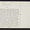
Sanday, Augmund Howe West, HY63NE 5, Ordnance Survey index card, page number 1, Recto |
1958 |
Item Level |
|
 |
On-line Digital Images |
SC 2343912 |
Records of the Ordnance Survey, Southampton, Hampshire, England |
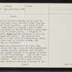
Sanday, Augmund Howe West, HY63NE 5, Ordnance Survey index card, page number 2, Verso |
1958 |
Item Level |
|
 |
On-line Digital Images |
SC 2343913 |
Records of the Ordnance Survey, Southampton, Hampshire, England |
Sanday, Augmund Howe West, HY63NE 5, Ordnance Survey index card, page number 3, Recto |
1958 |
Item Level |
|
 |
On-line Digital Images |
SC 2343914 |
Records of the Ordnance Survey, Southampton, Hampshire, England |
Sanday, Augmund Howe West, HY63NE 5, Ordnance Survey index card, page number 1, Recto |
1958 |
Item Level |
|
 |
On-line Digital Images |
SC 2343915 |
Records of the Ordnance Survey, Southampton, Hampshire, England |
Sanday, Augmund Howe West, HY63NE 5, Ordnance Survey index card, page number 2, Verso |
1958 |
Item Level |
|
 |
On-line Digital Images |
SC 2343916 |
Records of the Ordnance Survey, Southampton, Hampshire, England |
Sanday, Augmund Howe West, HY63NE 5, Ordnance Survey index card, page number 3, Recto |
1958 |
Item Level |
|


