
Following the launch of trove.scot in February 2025 we are now planning the retiral of some of our webservices. Canmore will be switched off on 24th June 2025. Information about the closure can be found on the HES website: Retiral of HES web services | Historic Environment Scotland
Airdrie House


Country House (16th Century)
Site Name Airdrie House
Classification Country House (16th Century)
Alternative Name(s) Airdrie House Policies
Canmore ID 34005
Site Number NO50NE 1
NGR NO 56662 08463
Datum OSGB36 - NGR
Permalink http://canmore.org.uk/site/34005


- Council Fife
- Parish Crail
- Former Region Fife
- Former District North East Fife
- Former County Fife
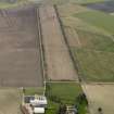
NO50NE 1.00 56662 08463
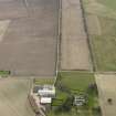
(NO 5666 0846) Airdrie (NR)
OS 6" map (1919).
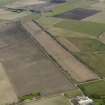
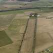
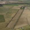
NO50NE 1.01 NO 56636 07812 Avenue
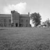
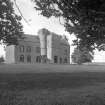
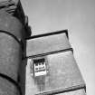
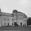
"The house of Airdrie...dates from 1588. It has, however, undergone considerable alteration, and few features of interest remain. On plan it is an oblong two-storeyed block lying east and west and measuring 78 3/4 by 21 1/2 feet. A wing 12 1/2 ft. square at base, but offset above, projects on the southern side." A little window above an empty panel space on the east side, is set between finials dated 1588 and terminating in human heads. "The masonry is harled, the dressings being exposed. The windows of the main block have been enlarged, and the roof, skews, and chimney-stalks are modern.
John 'de Lummysden' had the barony of Airdrie in 1450. In 1605 Robert Lumsden...sold the lands and barony to William Turnbull of Pittencrieff.
RCAHMS 1933.
Name confirmed as "Airdrie".
Information from P S Skimmimg, owner, Airdrie.
Airdrie is as described by RCAHMS, and is in good condition.
Visited by OS (DS), 16 October 1956
As described by RCAHMS.
Visited by OS (WDJ), 23 August 1968
Field Visit (18 June 1927)
Airdrie.- The house of Airdrie, lying two and three-quarter miles west-northwest of Crail, dates from 1588. It has, however, undergone considerable alteration, and few features of special interest remain. On plan it is an oblong two-storeyed block lying east and west and measuring 78 ¾ by 21 ½ feet. A wing, 12 ½ feet square at base but off-set above, projects on the southern side at 28 feet west of the east gable. This originally contained a scale-and-platt stair and two upper chambers, one above the other, but the staircase (which led to the first floor of the main block) has now been removed. A turret, corbelled out on a squinch arch within the western re-entrant angle, houses a stair which serves the upper floors of the main block and the lower chamber of the wing. Its upperpart is developed to the square and is surmounted by a parapeted look-out reached from a second turret-stair, corbelled out within the eastern re-entrant angle and giving access alsoto the upper chamber of the wing. This latter stair terminates in a cap-house with a domed stone roof, lying within a parapet which is pierced with quatrefoiled loops to west and south and has two tiny mock turrets on the southern side. On the wing, and returning round the western turret, are two moulded courses, the lower enriched with a cable ornament. On its eastern face is the lintel of an upper window bearing a monogram, apparently M.C.L.O.A., flanked by a lion rampant and a boar or otter. Over it is an empty panel-space having a border sculptured with animals on the upper part and with male figures at the sides. A little window above is set between finials dated 1588 and terminating in human heads. The masonry is harled, the dressings being exposed. The windows of the main block have been enlarged, and the roof, skews, and chimneystalks are modern. Internally the house has been modernised, and a new staircase has been constructed within the main block.
HISTORICAL NOTE.- John ‘de Lummysden’ had the barony of Airdrie in 1450 (1). In 1605 Robert Lumsden with consent of his wife Isobelle Cor sold the lands and barony to William Turnbull of Pittencrieff (2). Forty years later, lands and barony ‘with the tower and manor-place’ were in possession of John Preston, eldest son of Sir John Preston of Pennycook (3). At the beginning of the 18th century the place belonged to Mr. Philip Anstruther (4).
RCAHMS 1933, visited 18 June 1927.
(1) Reg. Mag. Sig., s.a., No. 402. (2) Ibid., s.a., No. 605. (3) Ibid., s.a., No. 1607. (4) Sibbald's History of Fife, Etc. (ed. 1803), p. 360.
Photographic Survey (July 1960)
Photographic survey by the Scottish National Buildings Record in July 1960.
Photographic Survey (July 1960)
Photographic survey by the Scottish National Buildings Record in July 1960.

