
Dundee, Claypotts Castle


Tower House (Medieval)
Site Name Dundee, Claypotts Castle
Classification Tower House (Medieval)
Canmore ID 33397
Site Number NO43SE 16
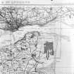
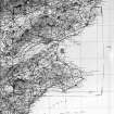
NGR NO 45279 31956
Datum OSGB36 - NGR
Permalink http://canmore.org.uk/site/33397


- Council Dundee, City Of
- Parish Dundee (Dundee, City Of)
- Former Region Tayside
- Former District City Of Dundee
- Former County Angus
NO43SE 16 45279 31956
(NO 45279 31956) Castle (NR)
OS 1:10,000 map (1974)
See attached pamphlet for full description and history.
M R Apted 1957
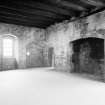
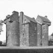
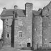
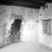
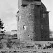
Excellent state of preservation.
Visited by OS (JLD) 30 April 1958.
The pamphlet by Apted (1957) is held in the NMRS, Edinburgh.
Information from RCAHMS
NMRS REFERENCE:
NMRS Print Room
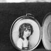
W Schomberg Scott Photograph Collection Acc no 1997/39
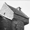
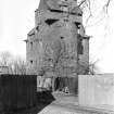
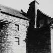
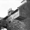
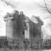
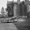
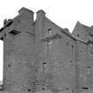
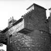
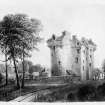
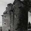
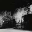
General view of exterior.
EXTERNAL REFERENCE:
Scottish Historical Review Vol 2 No 5 p.72 - text.
(Undated) information in NMRS.
Photographic Survey (1961)
Photographic survey by the Scottish National Buildings Record in 1961.
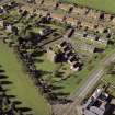
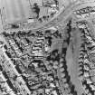
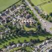
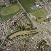
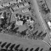
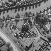
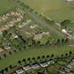
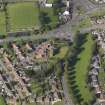
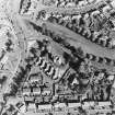
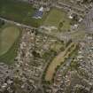
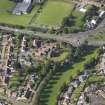
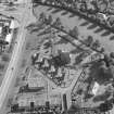
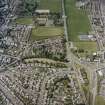
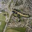
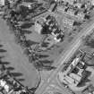
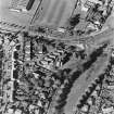
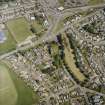
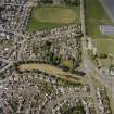
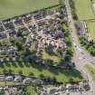
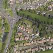
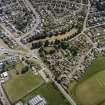
Aerial Photography (September 1970)
Oblique aerial photographs of Claypotts Castle, Dundee, taken by John Dewar in September 1970.
Publication Account (1987)
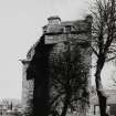
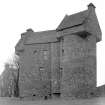
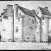
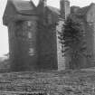
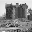
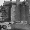
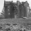
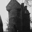
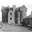
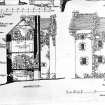
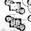
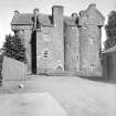
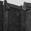
The 'Tower Fortalice and Mannor Place' of Claypotts was erected between 1569 and 1588. The lands are referred to in documents from 1247 when they were described as belonging to the Abbey of Lindores (NO 243184) on the south side of the Firth of Tay. This tower-house is one of the most complete examples of the type of planning found in a number of other 16th century buildings. It was erected by John Strachan or Strathauchin, a cadet branch of Strachan of Angus and Thornton in the Mearns.
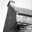
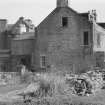
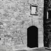
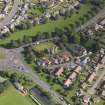
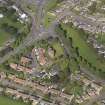
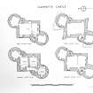
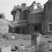
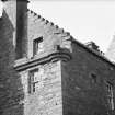
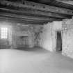
The adoption of a Z-shaped plan form for a tower of three storeys and attic provides a greater number of rooms and a higher degree of domestic comfort than had hitherto been the norm. The staggered, three-unit plan not only provided more rooms but better defensive coverage as the shot-holes in the end units allowed defenders to fire across the faces of the main building. The end units were treated as drums on diagonally opposite corners of the main building and these were capped with square penthouses with pitched roofs and crowstepped gables. This gave the building a richly modelled form and a complex and dramatic skyline. All of the richness was concentrated in the upper floor, the lower portion depending on the juxtaposition of flat to curved walls for its interest. It should be remembered that this tower-house, like all the others in the region, would have been situated in a fermtoun and would have had its own farm steading around it. The layout for this is not known but the improved steading, built in the 19th century, stood to the west of the tower-house on the ground now occupied by a small housing development. This steading was demolished in the early 1960s.
Little is known of the estate organisation or the day-today life in the house when it was first erected, but the will of John Strachan, the feuar who had the castle built, gives some clues. Four tenants of Claypotts lands were listed as witnesses, suggesting that at least four families lived in the fermtoun in addition to the Strachans. The estate livestock amounted to: fourteen working oxen, five cows, seven bullocks, two workhorses, nineteen ewes with their lambs, and sixty ewes with their wethers (lambs in the second year). The sown crops amounted to: eight boIls of oats (expected return thirty-two bolls plus fodder), fifty bolls of oats (to return one hundred and fifty bolls plus fodder), fourteen bolls of bere, a form of barley (to return fifty-six bolls plus fodder), and six bolls of pease (to return twenty-four bolls). The house contents and utensils were valued at 100 marks. The total inventory of stock and utensils amounted to £1,118-s-8d Scots on 27th April 1593.
At the beginning of the 17th century the superiority of Claypotts passed to the newly-created Barony of Lindores. The Strachans moved north to Balhousie, a farm adjacent to their lands at Scryne. They sold Claypotts to Sir William Graham of Ballunie in 1601. Graham took the title 'of Claypotts' and transferred the lands to his son David in 1616. David was the last owner to occupy the house and in 1620 sold the estate to Sir William Graham of Claver house for 12,000 marks. The Claverhouse lands were declared forfeit after the Battle of Killiecrankie in 1689 and reverted to the Crown. They were granted by Royal Charter in 1694 to lames, 2nd Marquis of Douglas. It still forms part of the Douglas and Angus estates under Sir Alex Douglas Home. The house was placed under the guardianship of the Commissioners of Works in 1926.
Information from ‘Exploring Scotland’s Heritage: Fife and Tayside’, (1987).
Watching Brief (2002)
Watching brief undertaken by SUAT Ltd during new water service pipe installation at Claypotts Castle, Dundee.
Watching Brief (June 2021)
NO 4527 3195 A watching brief was required, in June 2021, to monitor ground-breaking works for the installation of a new lectern sign. No significant archaeology was identified.
Archive NRHE
Funder: Historic Environment Scotland
Rachel Ford – CFA Archaeology Ltd
(Source: DES Vol 22)

