
Dundee, Tay Bridge


Railway Bridge (19th Century)
Site Name Dundee, Tay Bridge
Classification Railway Bridge (19th Century)
Alternative Name(s) River Tay; New Tay Bridge; Tay Rail Bridge; Tay Railway Bridge; Firth Of Tay; Outer Tay Estuary
Canmore ID 31692
Site Number NO32NE 11
NGR NO 39143 27850
Datum OSGB36 - NGR
Permalink http://canmore.org.uk/site/31692


First 100 images shown. See the Collections panel (below) for a link to all digital images.
- Council Dundee, City Of
- Parish Dundee (Dundee, City Of)
- Former Region Tayside
- Former District City Of Dundee
- Former County Angus
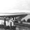
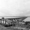
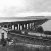
Built between 1882-7, the Tay Railway Bridge was constructed by engineers W H and Crawford Barlow for the North British Railway. It is the longest bridge in Britain and consists of a series of wrought-iron trusses on riveted plate piers with brick foundations. The structure incorporates some of the trusses of the first bridge (completed 1878 and partly blown down 28 December 1879), and the stumps of the piers of the old bridge can be seen downstream.
Hume, J R 1977
NO32NE 11 39143 27850
Tay Bridge [NAT] (name centred NO 391 277)
OS 1:10,000 map, 1991.
For corresponding road bridge (NO 425 287 to NO 407 300), see NO42NW 75.
See also;
NO32NE 17 NO 390 292 to NO 395 263 Dundee, Old Tay Bridge
NO32NE 28 NO 3957 2633 South Signal Box
NO32NE 25 NO 3920 2930 Dundee, Esplanade Station (situated on N approach)
NO32NE 31 NO 3963 2627 Wormit Station
NO32NE 397 NO 39574 26371 Tay Bridge Life Boat Rescue Station
NO32NE 8005 NO 3982 2645 salvage barque
NO42NW 83.00 NO 4016 2974 to NO 4035 2991 Dundee, Tay Bridge Station
Location formerly entered as NO 390 292 to NO 395 263.
NMRS REFERENCE:
Dundee, Railway Bridge (New).
W.H.Barlow & Crawford 1886.
(Iron work by Sir William Arrol).
(Undated) information in NMRS.
(Location cited as NO 395 263 to NO 392 293). Tay Railway Bridge, built 1882-7 for the North British Rly by engineers W H and Crawford Barlow. The longest bridge in Britain. Consists of a series of wrought-iron trusses on riveted plate piers with brick foundations. The structure incorporates some of the trusses of the first bridge (completed 1878 and partly blown down 28 December 1879); the stumps of the piers of the old bridge can be seen downstream.
J R Hume 1977.
The new bridge was built by Tancred and Arrol of Glasgow and opened to traffic on 20 June 1887, being the last of the great wrought iron railway bridges; it remains in use.
Since opening, the bridge has needed little other than routine maintenance, the expansion bearings being replaced between 1953 and 1965, and sections of the deck subsequently.
M Smith 1994.
This bridge carries the Edinburgh-Aberdeen main line of the former North British Rly. (grouped into the London and North-Eastern Rly.) across the estuary of the River Tay between the parish of Forgan (North-East Fife District, Fife Region) and the City Parish of Dundee (City of Dundee District, Tayside Region and former county of Angus), to the S and N respectively.
Information from RCAHMS (RJCM), 5 January 1996.
Site recorded by Maritime Fife during the Coastal Assessment Survey for Historic Scotland, Fife Ness to Newburgh 1996
Comparable 'Whipple-Murphy' bow truss construction has been noted in railway bridges at Bargeddie, Monkland (NS66SE 141) and Deedes Road, Airdie (NS76NE 22).
Information from RCAHMS (RJCM), 22 December 2005.
The location assigned to this record defines the midpoint of its length. The available map evidence indicates that it extends from NO c. 39107 29267 to NO c. 39558 26321.
The curving N spans of the bridge cross Riverside Junction (Dundee Esplanade) while the S end of the bridge incorporates Wormit Junction (with the East Fife coastal branch line).
Information from RCAHMS (RJCM), 21 April 2006.
Field Visit (1974)
Publication Account (1987)
The original Tay Rail Bridge was designed for the North British Railway Company by Sir Thomas Bouch. It was an ambitious project to build a bridge over 3.2km long across the exposed estuary of the Firth of Tay. Few of the problems associated with the construction of long bridges in exposed sites had been considered at that time. Bouch took advice on wind forces but was given a ridiculously low figure. Similarly the rolling-stock in use at that time was not tested for stability in exposed situations.
The bridge carried a single railway track for 3,261m across the Firth. Work was started in 1871 and the bridge was opened in 1878. It is not certain what caused the bridge to collapse but the slender nature of the design, the poor quality of the workmanship and the possibility that the train may have been exceeding the speed limit of twenty-five miles per hour or may have been derailed by the force of the wind may all have contributed to its failure. The bridge collapsed within nineteen months of its opening and Bouch was apportioned most of the blame. There are a great many books and articles on the subject and with hindsight Bouch appears to have been badly judged. The brick column bases used to support the cast-Iron columns of the first bridge may still be seen on the east side of the second bridge.
In 1882 the North British Railway Company commenced work on the second bridge. The engineers were W H Barlow and Sons and the contractor was William Arrol and Company of Glasgow. The second bridge was sited 18m upstream from the original. Since the regulations in force at that time did not allow the use of steel for bridge construction, many of the wrought-iron girders from the Bouch design were re-used by Barlow. The new bridge was nearly 3.5km long and had eighty-six piers, seventy-six of which were in the river.
Sir William Arrol also built the Victoria Bridge at Caputh (NO 088395) for William Cox ofSnaigow and Foggyley. The bridge was started in 1887 and made use of girders of identical design to those used on the Tay Bridge.
Information from ‘Exploring Scotland’s Heritage: Fife and Tayside’, (1987).
Reference (1994)
The new bridge was built by Tancred and Arrol of Glasgow and opened to traffic on 20 June 1887, being the last of the great wrought iron railway bridges; it remains in use.
Since opening, the bridge has needed little other than routine maintenance, the expansion bearings being replaced between 1953 and 1965, and sections of the deck subsequently.
M Smith 1994.
Note (5 January 1996)
This bridge carries the Edinburgh-Aberdeen main line of the former North British Rly. (grouped into the London and North-Eastern Rly.) across the estuary of the River Tay between the parish of Forgan (North-East Fife District, Fife Region) and the City Parish of Dundee (City of Dundee District, Tayside Region and former county of Angus), to the S and N respectively.
Information from RCAHMS (RJCM) 5 January 1996
Field Visit (September 1996 - October 1996)
Aerial Photography (15 September 2000)
Note (22 December 2005)
Comparable 'Whipple-Murphy' bow truss construction has been noted in railway bridges at Bargeddie, Monkland (NS66SE 141) and Deedes Road, Airdie (NS76NE 22).
Note (21 April 2006)
The location assigned to this record defines the midpoint of its length. The available map evidence indicates that it extends from NO c. 39107 29267 to NO c. 39558 26321.
The curving N spans of the bridge cross Riverside Junction (Dundee Esplanade) while the S end of the bridge incorporates Wormit Junction (with the East Fife coastal branch line).
Publication Account (2007)
The Tay is a shallow estuary, nearly two miles wide at Dundee, with many sandbanks and a depth of water rarely exceeding 50 ft. The present railway bridge is the second at the same site, the first having collapsed barely 18 months after its opening.
The first Tay Bridge was designed in the 1870s for the North British Railway by its Engineer Thomas Bouch and carried a single line of railway on 89 spans. Thirteen of these spans were navigation spans higher and longer than the others. The spans were originally to have been carried on tall piers of brickwork founded on solid rock but, owing to faulty site investigation and difficulties with the foundations, the majority of the piers had to be lightened and were made of poorly constructed ironwork which was insufficiently anchored at its base. In a gale on 28 December 1879 all the navigation spans fell while a train was crossing and 75 lives were lost. Although the bridge had stood for only 18 months it had more than demonstrated its usefulness, and the North British Railway determined to rebuild it. The present bridge 10 711 ft in length and double track was engineered by W. H. Barlow from 1881, assisted by his son and partner Crawford Barlow. Although structural steel was coming into use, no substantial bridges in Britain had been completed using it, and it was decided to use 21 078 tons of wrought-iron girders capable of bearing 22 tons sq. in. in tension, plus 3588 tons of steel in the flooring. The contractor was William Arrol, who designed innovative temporary works, including pontoon jack-upplatforms (see illustration). He proved more than equal to this mammoth task.
Construction took place from 1882–87, on a parallel line 60 ft upstream from the old bridge. The spans were kept the same as Bouch’s bridge, which allowed the original iron girders (which were sound, unlike the ironwork of the piers) to be reused as facing girders except on the navigation spans which were entirely renewed. The new piers were substantial and well anchored.
Network Rail’s recent sensitive refurbishment of the bridge won the Saltire Civil Engineering Award for 2003.
Paxton and Shipway 2007
Reproduced from 'Civil Engineering heritage: Scotland - Lowlands and Borders' with kind permission from Thomas Telford Publishers.
Publication Account (2013)
The engineers for the new Tay Rail Bridge, W H and Crawford Barlow, and the principal contractor, Sir William Arrol and Co. Ltd., transferred 118 old girders upstream to new arched wrought-iron plate piers, twice the width of the old bridge. Completed in 1887, the total length of the new bridge is 10,711 feet (3,265m). The bridge slopes down from a signal box at Fife to Dundee, threading its twin tracks through 13 hog-back trussed navigation spans, and then curves gently to give a prospect of the city, crossing Riverside Drive on arches, passes the closed Esplanade Station, then descends on fish-bellied trusses and brick arches into a cutting.
In 2000-2003 local strengthening was achieved by mechanically fixing 16mm thick plate to parts of each girder and shock absorbers to the curve (Lewis, 2004).
M Watson, 2013

