
Cardean


Roman Fort (Roman)
Site Name Cardean
Classification Roman Fort (Roman)
Canmore ID 30689
Site Number NO24NE 12
NGR NO 28900 46000
NGR Description Centred NO 28900 46000
Datum OSGB36 - NGR
Permalink http://canmore.org.uk/site/30689


- Council Angus
- Parish Airlie
- Former Region Tayside
- Former District Angus
- Former County Angus
NO24NE 12.00 centred 28900 46000
NO24NE 12.01 NO 289 460 Bronze Pendant; Pottery; Miscellaneous Finds
(Centred at NO 2890 4600) Roman Camp (R) (Site of)
(Centred at NO 288461) Earthen Vessels, etc found (NAT)
OS 6" map (1959)
For fragments of Roman amphora found 'near Meigle' and possibly from Cardean, see NO24SE 14.
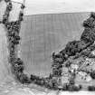
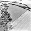
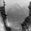
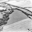
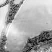
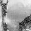
Most of the Roman fort at Cardean is visible on AP's. St. Joseph suggests there may have been more than one fort because of the varying widths of the ditches and causeways. The whole of the NE. and SE. sides, c.550' in length, with a central gateway in each, two main streets and some side streets may be seen. A road leading through the NE. gate bends slightly S. to follow the crest of the ridge. Broad ditches running from the E. and W. angles may delimit an annexe enclosing the spur of land between the Isla and the Dean Water.
Partial excavations carried out between 1966-8 showed the NW. rampart to have had a 20' wide turf base, and two 10' wide ditches. On the inner side of the rampart there were very heavy laid stoneworks, behind which ran a cobbled inter-vallum street. On the inner side of the street there was a wooden barrack block at right-angles to the rampart. Entrances in the two NW. ditches were located.
Three ditches were found at the E. corner of the fort, the inner 16' wide by 5' deep, the second 27' by 8' deep, the third 53' wide by 9' deep.
The finds indicated a single Flavian occupation.
J K St Joseph 1951, 1965; J J Robertson 1966, 1967; Name Book 1861; A S Robertson 1968
The site of the fort is under cultivation but the rampart can be traced as a low spread mound accompanied by a broad ditch on the NE, and SE. sides. Breaks in the rampart indicate the sites of three of the gates in the NE., SE. and SW. sides. The road is clearly visible entering the NE. gate as a low agger with a scatter of metalling. It leaves the SW. gate by means of a gully leading to the river.
Surveyed at 1:2500 by means of AP's and ground measurement.
Visited by OS (JP) 16 February 1970
Excavations carried out from 1968 to 1972 by the Scottish Field School of Archaeology,directed by Dr A.S. Robertson, established that the defences on the north and SE consisted of a turf rampart, 6.1m. wide, with four external ditches. The gateway on the north was 12m. wide. Finds confirm the single Flavian occupation, ending in abandonment shortly after 86AD.
The occurence of I.A.native rim-sherds in the interior of the fort and underlying the rampart suggest that a small native settlement was removed to make way for the fort.
D R Wilson 1969, 1971, 1972; A S Robertson 1970, 1971, 1972
Bun-shaped quern RMS BB 124.
E J MacKie 1971.
NO 288 459 The Roman Gask Project conducted a 7.3ha survey of the promontory of Cardean, to gain a better understanding of the site and clarify a number of problems raised by the excavations of the 1960s and 1970s. The methods employed were fieldwalking, in co-operation with the Perthshire Society for Natural Science - Archaeology Section, over the harvested field at 10m and 2m intervals, as well as a selective metal-detector survey. These exercises yielded numerous items of an 18th to 20th-century nature, a large amount of lead, as well as two copper-alloy discs, which may be Roman coins. The core element of the survey was, however, a resistivity survey, covering most of the headland.
But for a 20m wide strip along the southern fence, the survey was able to trace the full extent of the surviving Roman fort which appears to be 207 x 179m over the ramparts (c 3.7ha inside the ditches) in size. This puts Cardean amongst the largest forts in Britain. The fort itself was surrounded by a complex ditch system, which also included two annexes: one in the SW on the very tip of the promontory and one to the SE. Combined, these effectively closed access to the promontory from the NE by a large continuous system of ditches.
Besides these clearly identifiable features, the survey also highlighted a large area of rig and furrow to the W of the fort, suggesting medieval activity on the site, as well as a number of circular features (possibly simple roundhouses) along the N edge of the field. These features appear to be associated with a forked feature, suggesting a prehistoric ditch system on the site as well as a number of pits. In the southern part of the promontory, close to the steep erosion edge to the Dean Water, another feature was tentatively interpreted as a complex roundhouse.
The inside of the Roman fort appears to have been disturbed by an 18th-century road with side ditches, as well as a large rectangular feature that obliterates traces of the Roman road system in the centre of the fort, but appears itself to have been cut by the Early Modern road.
A period of flooding after heavy rainfall during the survey allowed for the documentation of an old river channel of the Isla at the very edge of the headland, suggesting that there may have been easier access in the past to the seasonably navigable Isla from the promontory than is apparent today.
Sponsor: Historic Scotland
B Hoffmann 2001
Note (1983)
Cardean, Fort NO 289 460 NO24NE 12
Situated on a promontory at the confluence of the River Isla and the Dean Water, there is a fort measuring about 180m from NW to SE by 140m transversely within the rampart (c. 2.5ha). Excavation between 1966-75 revealed the presence of timber barracks in both the praetentura and retentura, as well as a large timber granary, and it is probable that the fort accommodated two separate regiments. Only one brief period of occupation was detected, the artefactual and structural evidence indicating that the fort was peacefully evacuated in c. AD 86. Iron Age pottery discovered beneath the rampart and internal structures presumably derived from an earlier native unenclosed settlement occupying the same site. Additional protection was provided by a ditch which crosses the promontory some 180m to the NE of the fort, the outwork being broken for an entrance opposite the short stretch of road that issues from the NE gate of the fort. Ditches springing from the fort's defences at the E and Wangles probably delimit annexes.
RCAHMS 1983.
(Name Book, Forfar, No. 2, p. 54; DES, 1975, 8).
Measured Survey (5 March 2003 - 7 March 2003)
A GPS survey was carried out, during which height points were collected over the area covered by Cardean Roman Fort. A terrain model and contours were created from the data.

