
Rait


Fort (Period Unknown)
Site Name Rait
Classification Fort (Period Unknown)
Canmore ID 30457
Site Number NO22NW 6
NGR NO 22989 26788
Datum OSGB36 - NGR
Permalink http://canmore.org.uk/site/30457


- Council Perth And Kinross
- Parish Kilspindie
- Former Region Tayside
- Former District Perth And Kinross
- Former County Perthshire
Field Visit (1900)
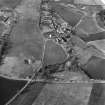
Earthwork, Rait. A narrow, steep-sided spit of land is cut off by three slightly curved and massive mounds, 30 to 40ft wide and rising 7 to 8ft above the two intervening trenches. A ramp-entrance crosses the lines obliquely. The length of the cut-off spit is about 500ft, its height 25 to 30ft, and it ends by an abrupt descent to the highway at the very edge of the Carse. Its naturally scanty width has been much narrowed by the quarrying of sand and gravel from its western face, so that in some places the top is now a mere crest a few feet wide.
D Christison 1900
Field Visit (19 July 1956)
This site was included within the RCAHMS Marginal Land Survey (1950-1962), an unpublished rescue project. Site descriptions, organised by county, are available to view online - see the searchable PDF in 'Digital Items'. These vary from short notes, to lengthy and full descriptions. Contemporary plane-table surveys and inked drawings, where available, can be viewed online in most cases - see 'Digital Images'. The original typecripts, notebooks and drawings can also be viewed in the RCAHMS search room.
Information from RCAHMS (GFG) 19 July 2013.
Field Visit (10 October 1963)
This site at NO 2299 2679 is generally as described above. The three ramparts are aligned roughly East to West and average 50.0m in length. The Northern and outer rampart has a maximum external height of 1.0m and maximum internal height of 1.2m with an average width of 6.0m.
The centre rampart has maxima of 2.0m external height, 2.3m internal height and 8.0m width while those of the inner rampart are 2.3m external height, 1.0m internal, 7.0m width.
The ramp entrance mentioned by Christison cuts through the inner and centre ramparts which have gaps 2.0m wide but is not in evidence on the outer line which does not appear to have a break in it. The ramp is most prominent between the inner and medial ramparts where it is 0.4m above the ditch bottom. The site is tree covered and partially obscured by dense undergrowth. The gravel pit has left practically nothing of the hill which the defences cut off.
Revised at 25".
Visited by OS (RDL) 10 October 1963
Field Visit (17 May 1989)
The remains of this unusually small fort are situated on a low-lying promontory. Severely truncated on the SW by erosion, the fort now measures only 35m by 20m internally, but its defences, which comprise two ramparts with external ditches are still intact. The inner rampart measures up to 4.8m in thickness and 0.6m in internal height, and two stones of its outer revetment can still be seen; it is fronted by a ditch up to 7m in breadth and 0.9m in depth. There are also traces of a counterscarp on the outer lip of the outer bank but this is largely obscured by a recent field-bank. There is a modern break through the centre of the N defences, but the original entrance was on the NW, where a track climbs obliquely up the slope and the terminals of the ramparts are linked by a stony bank. Within the fort there is a roughly circular setting of boulders measuring about 2m in diameter and 0.2m in height overall; its function is unknown.
Visited by RCAHMS (JRS) 17 May 1989.
Measured Survey (1 May 1989)
RCAHMS surveyed the fort at Rait (NO22NW 6) with plane-table and self-reducing alidade on 1 May 1989 at a scale of 1:500. The resultant plan was redrawn in ink as part of a ‘Comparative plans of upstanding forts’ illustration and published at a scale of 1:2500 (RCAHMS 1994b, 53).
Watching Brief (2001)
NO 231 269 During November 2000 an archaeological evaluation was undertaken in fields at Rait Hill, followed by a watching brief in December 2001. The site was considered archaeologically sensitive due its close proximity to the Rait Iron Age fort and aerial photographic evidence of cropmarks (NMRS NO 22 NW 64 and 65), which showed other possible prehistoric activity, as well as rig and furrow within the application area.
The evaluation revealed survival of remains relating to the outer defence work of Rait fort, which protruded into the application area, and excavation to the N of this identified a hitherto unknown outer ditch. Several other small features were also identified. In addition to the identified features an isolated cluster of worked quartz was found - most likely prehistoric in date. No features attributable to the cropmarks, which were identified within the site, were located. The cropmarks of rig and furrow were preserved in areas where the topsoil was very deep, so no trace of these remained once the topsoil had been stripped. Other features were probably geological in origin.
The defensive ditch of Rait fort found during the evaluation was to remain untouched. The fort was protected with a fenced-off exclusion zone, and an area in front of the zone was covered with geotextile before any topsoil could be dumped here.
The watching brief was carried out during topsoiling and revealed five features of archaeological interest, on a ridge of high ground near to Rait fort. Upon excavation they were revealed to be discrete features for which no date or function could be ascribed.
Sponsor: R J McLeod (Contractors) Ltd.
R Cachart 2001
Note (11 May 2015 - 31 May 2016)
This small fortification is situated on a promontory immediately E of Rait. Its defences comprise three ramparts with external ditches, the outer known only from excavation (Cathcart 2001), which cut across the neck on the N to bar access to an area now measuring 35m from E to W immediately to the rear of the inner rampart by no more than 20m transversely (0.05ha). The present size of the interior, however, is deceptive; it is shown on the 1st edition OS 25-inch map (Perth and Clackmannan 1867, sheet 87.14) as a narrow spine some 120m long and 10m wide, having been quarried already at its S tip by 1861, and reduced still further to no more than 80m in length by 1901. Making due allowance for this loss, it may originally have extended to about 0.15ha. The entrance was by way of a trackway that approaches obliquely up the slope from the NW below the W terminal of the defences.
Information from An Atlas of Hillforts of Great Britain and Ireland – 31 May 2016. Atlas of Hillforts SC3047

