
Following the launch of trove.scot in February 2025 we are now planning the retiral of some of our webservices. Canmore will be switched off on 24th June 2025. Information about the closure can be found on the HES website: Retiral of HES web services | Historic Environment Scotland
Glasgow, Dalbeth, River Clyde M74 Bridge


Road Bridge (21st Century)
Site Name Glasgow, Dalbeth, River Clyde M74 Bridge
Classification Road Bridge (21st Century)
Canmore ID 302961
Site Number NS66SW 990.01
NGR NS 63474 62441
Datum OSGB36 - NGR
Permalink http://canmore.org.uk/site/302961


- Council Glasgow, City Of
- Parish Glasgow (City Of Glasgow)
- Former Region Strathclyde
- Former District City Of Glasgow
- Former County Lanarkshire
Project (September 2014 - 2015)
This project, which was largely undertaken in 2015 and 2016, initially comprised a desk-based qualitative assessment of about 360 Canmore records for which a direct association with the River Clyde could be demonstrated, identifying which records could be enhanced, and how, in a subsequent project. The desk-based phase of the project was followed by a programme of fieldwork (https://canmore.org.uk/project/1024867) which identified over 300 previously unrecorded sites along the river.
Desk Based Assessment (11 August 2017)
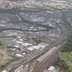
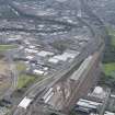
The Auchenshuggle Bridge carries the M74 over a 90m span of the River Clyde between junction 2 and 2a. It was built as part of the northern extension of the M74, completed in 2011. A single span bridge supported at each end by reinforced concrete supports, it is a dual-three lane motorway bridge, carrying both carriageways of the M74. Cleveland Bridge supplied and erected the 7 lines of curved steel box bridge girders, which had a combined weight of 1,840 tonnes and required Europe’s largest mobile strut jib crane to lift in to place. (Info from http://www.clevelandbridge.com/our-work/m74-motorway-bridges/ (accessed 11/08/2017)).
Information from HES Survey and Recording (AMcC) 11 August 2017.

