
Pricing Change
New pricing for orders of material from this site will come into place shortly. Charges for supply of digital images, digitisation on demand, prints and licensing will be altered.
Balbirnie


Cairn (Period Unassigned), Cup Marked Stone(S) (Neolithic) - (Bronze Age), Stone Circle (Neolithic) - (Bronze Age), Unidentified Pottery (Neolithic)
Site Name Balbirnie
Classification Cairn (Period Unassigned), Cup Marked Stone(S) (Neolithic) - (Bronze Age), Stone Circle (Neolithic) - (Bronze Age), Unidentified Pottery (Neolithic)
Canmore ID 29980
Site Number NO20SE 4
NGR NO 2850 0304
NGR Description Re-erected at NO 2859 0296
Datum OSGB36 - NGR
Permalink http://canmore.org.uk/site/29980


- Council Fife
- Parish Markinch
- Former Region Fife
- Former District Kirkcaldy
- Former County Fife
NO20SE 4 2850 0304
(NO 2850 0304) Standing Stones (NAT)
OS 6" map (1947)
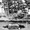
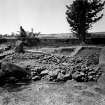
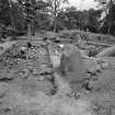
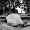
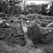
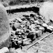
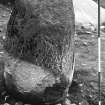
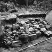
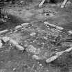
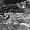
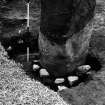
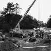
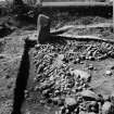
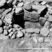
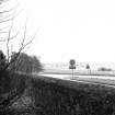
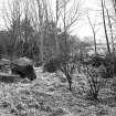
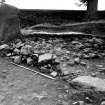
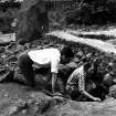
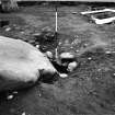
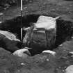
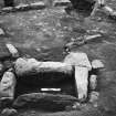
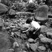
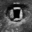
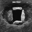
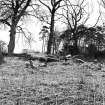
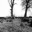
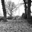
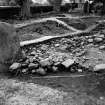
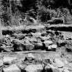
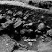
Excavation of the cairn at Balbirnie was undertaken in June 1970 in advance of widening operations on the trunk road A92. The site comprised a cairn some 15m in diameter at the edge of which, forming part of the kerb, were a series of standing stones. Five standing stones were visible before excavation and the stump of a sixth was found in the course of it; it is possible that a further stump or stone hole may exist on the NW in a small portion of the site unexcavated owing to the presence of a tree. Beneath the cairn and dug into the natural surface were three complete and two disturbed cists and a rectangular setting of low oblong stones 3.25 x 3.75m across. The site had been disturbed in the past, not only by excavations in the 1880's, but also by the planting and subsequent extraction of several trees. For this reason the sequence of phases on the site cannot be proved by stratigraphy and the scheme outlined here is tentative.
The earliest phase on the site is probably represented by the oblong stones and possibly the ring of standing stones. There is no evidence of the date of this phase but it is possible that the future excavation of the holes in which the standing stones and the setting have been set will provide additional information.
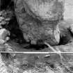
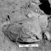
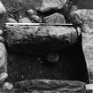
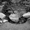
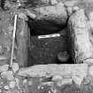
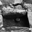
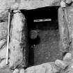
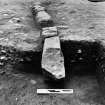
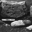
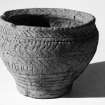
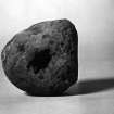
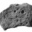
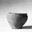
The second phase is represented by a series of cists and a pit (possibly the remains of a cist) dug into the natural gravel. It can be shown that two of these are later than the rectangular setting as they cut across it, but the precise relationship of the others is uncertain. One had been completely robbed and only one side slab remained; in the pit were several large slabs, one of which had a deliberately shaped edge and it is thus likely that this represents another cist. There were no finds in either of these disturbed cists. A third cist had also been disturbed, possibly when the cairn was built; it contained a side slab decorated with cup and ring markings. Two further cists were discovered - one containing a cremated burial, a complete Food Vessel and a plano-convex flint knife, and the other a cremated burial and a small bone toggle. One of the packing stones behind the Food Vessel cist was found to be decorated with seventeen cup marks. All the cists must now be removed from the holes in which they have been set to check that there are no further decorated stones.
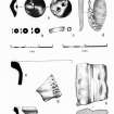
A V-bored jet button, a number of jet disc beads and sherds of several vessels, are probably attributable to this phase.
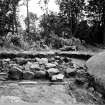
Phase three comprises the cairn of stones which covered the site; this stood to a height of 0.5m, filled the area within the standing stones, and was elsewhere kerbed by medium sized boulders. It is possible that initially the standing stones were linked by low banks, but this could be shown convincingly in only one place. Sherds of at least 11 Cinerary Urns and patches of cremated bone were found throughout the cairn material.
The span of the site is likely to be from Late Neolithic to the second half of the second millenium BC.
J Anderson 1886; RCAHMS 1933; J N G Ritchie 1970.
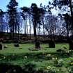
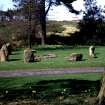
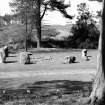
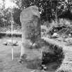
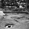
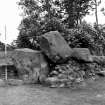
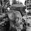
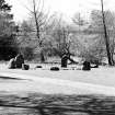
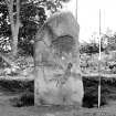
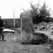
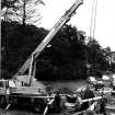
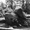
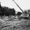
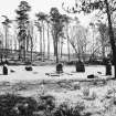
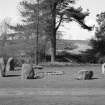
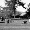
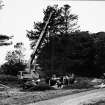
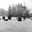
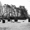
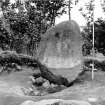
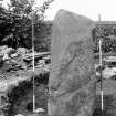
The excavation of the cairn and stone circle was completed, and the main features have since been re-erected by Glenrothes Development Corporation about 100m to the SE of the original site. The complete outline of the circle was recovered, including the holes of 2 stones which had been destroyed or damaged during the building of the estate wall. There were originally 10 stones belonging to a circle some 15m in diameter; 5 stones were visible before excavation, the stumps of 4 others and the stone hole of the remaining upright were discovered during the excavation. The most impressive stones were on the S half of the circle. In the holes of 4 of the stones on the E side of the circle there were scatters of cremated bones around and in 2 cases under the upright.
J N G Ritchie 1971
As stated by Ritchie, the main features of this site have been re-erected at NO 2859 0296.
Resurveyed at 1:2500.
Visited by OS (RD) 13 April 1972
Field Visit (17 June 1925)
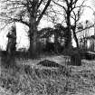
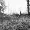
Cairn and Stone Circle, Balbirnie.
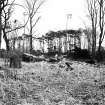
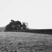
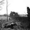
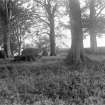
At the southern end of a small wood on the east side of the main road from Kirkcaldy to Falkland, about 180 yards south of Balbirnie Lodge, are the remains of a large circular cairn and of the setting of standing stones by which it was once surrounded [SC 1110928]. The spot is about 300 feet above sea-level. The circle, which has had a diameter of some 48 feet, has been composed of sandstone boulders. Four of these are still in place, but one other on the south-east has been slightly displaced, while against the stone on the north-east lie two large boulders, which apparently have been transferred to this position. Any other stones that may once have existed have been removed or destroyed. The greatest height above ground of any of those that survive is 5 feet 6 inches, while one, which rises no more than 2 feet, measures in circumference as much as 9 feet 9 inches at the base. The cairn itself seems to have been broken into at two points. No record of these excavations appears to be extant, but a number of fragments of cinerary urns from the site are preserved in the National Museum. These indicate that, as might have been inferred from its general character, the monument was sepulchral and dates from the Bronze Age. The monument is not marked in Gothic letters on the O.S. map (xix S.E).
RCAHMS 1933, visited 17 June 1925.
Excavation (1970)
Excavation of the cairn at Balbirnie was undertaken in June 1970 in advance of widening operations on the trunk road A92.
Source:
J N G Ritchie 1970.
Publication Account (1987)
These two sites (Balfarg and Balbirnie), along with structures that were found between them, form one of the most important groups of monuments of neolithic and bronze age date in eastern Scotland. The visible monuments are a henge and a small stone circle, now re-sited to the south-east ofits original position; excavations between them have, however, revealed a ditched enclosure, two timber structures, cairns and burials as well as a large quantity of pottery.
The henge monument of Balfarg was excavated in advance of house· building, but the development has been re-designed to allow the earthwork to form an open area, and now, with the partial digging out of the ditch, it offers a remarkable impression of the civil engineering skills of prehistoric man. The ditch encloses an area about 60m in diameter making use of a natural gully on its south-west flank; originally there would have been a large bank outside the ditch and together they would have formed a barrier around the central area. The entrance into the interior was across a narrow causeway on the west side. Several distinct phases of activity or construction were identified in the interior, the earliest involving the breaking of large numbers of pottery vessels and the burning of wood and bone. Later a circle of sixteen massive timbers was set up in pits with two unusually large timbers forming a detached 'porch' or entrance on the west side. These upright timbers are now marked by short posts, but the original posts may have been as tall as 4m on the west side of the circle to judge by the depth of the post-holes. The henge remained the focus for the construction of further rings of uprights, this time of stone. The surviving evidence is not as clear as in the earlier phase because the stones appear to have been set in hollows rather than in deep pits; nevertheless it may be suggested that there had been two concentric rings. The two ' impressive standing stones near the entrance causeway are, however, the only remaining features of this phase. The final period of prehistoric activity on the site is represented by the burial of a young person in a pit at the centre of the henge; the burial, accompanied by an unusual handled Beaker and a flint knife, was covered by a large slab weighing about two tons, which has been replaced in its original position.
At Balbirnie three burial phases of activity could be identified, although the disturbed nature of parts of the site meant that aspects of the sequence were tentative. There is no doubt, however, that the setting up of the ellipse of ten stones was the first phase with a rectangular kerbed area at its centre perhaps only a little later. Sherds of Grooved Ware pottery, in a style akin to that from Balfarg, were found within the filling of one of the sockets for one of the uprights. The purpose of the central setting is, however, obscure (it should be remembered that the crazy-paving within the reconstructed site is entirely modem). Perhaps a long time after the original building of the circle, the site was used as a burial-place. Two cists were constructed in pits which cut across the corners of the central setting, and this implies that its purpose had been forgotten by this time; the more central cist had been robbed in antiquity, and the burial which it contained had been scattered. The pit cutting through the north-west corner of the setting contained an undisturbed cist; when the capstone was removed the cist was found to be almost filled with earth and cremated bone (an adult female and a child), with a complete Food Vessel and a flint knife on the floor. One of the supporting stones behind the south end slab was decorated with seventeen cup-marks. Another small cist to the north-north-east of the centre contained a burnt bone toggle, while a disturbed cist to the south-east had a side slab decorated with cupmarkings and cup-and-ring markings; a cast of this slab has been used in the reconstruction.
Finally the interior of the circle had been covered by cairn material, perhaps covering smaller independent cairns that had protected the cists, and the cairn was used to receive deposits of cremated bones-as many as sixteen individuals-underlining the continued respect for the site as a focus for burials. After excavation in 1970 and 1971 the main elements of the site were re-erected by Glenrothes Development Corporation at a point some 125m SE of the original position. The pottery and decorated stones are on display in RMS, Queen Street, Edinburgh.
Information from ‘Exploring Scotland’s Heritage: Fife and Tayside’, (1987).
Note
Date fieldwork started: 02/03/2020
Compiled by: ACFA North Glasgow
Location notes: NMS Stores Granton Edinburgh, X.EP203 3/B/1
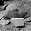
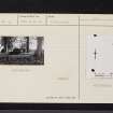
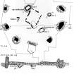
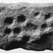
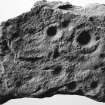
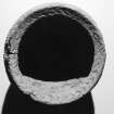
Panel notes: This is a rhomboid block of sandstone, 0.7x0.2m and 0.2m thick, with quarrying marks on long edges. The panel was found in the 1970 excavation of a burial cist at Balbirnie which contained a Food vessel, flint knife and cremated remains (Canmore ID 29980), and formed one of the packing stones behind the cist. A cup and ring marked stone (Balbirnie 2) was recovered from another cist during the same excavation. The rock is fairly uniform in colour and texture, being bright orange and of medium grain but with reddish bands running across its length. There is a darker brown-red patch at one end. On one flat surface there are 17 cupmarks forming rough linear alignments across the rock surface, and all showing obvious tool marks. Their sizes range from 2-5cm across, with one larger cup measuring 7cm across and conjoined to its neighbouring cup. On the edge of the panel are two further conjoined cups, and a single cup with an irregular groove running from it over the edge of the stone. All cupmarks are fairly shallow, 5-15mm deep. On the reverse face of the stone is one further cup mark.
Note
Date fieldwork started: 02/03/2020
Compiled by: ScRAP
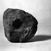
Location notes: National Museums of Scotland Collection Centre, X.EP 204
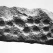
Panel notes: This is a rhomboid shaped slab measuring about 0.8 x 0.5m and 0.2m thick. The edges are broken on at least two sides, and there is some surface damage. The upper surface is rough with several pronounced bedding planes. There are 4 cups, one of which is more than 6cm diameter, 1 large cup (8cm diameter, 4cm deep) with a pennanular and short radial, 1 large cup with a pennanular, 1 cup with an arc, and 2 cups with a narrow radial. Tool markings are visible in most of the motifs and there are some roughly pecked linear features. The panel formed the side slab of a burial cist within a group of cists at Balbirnie excavated in 1970 (Canmore ID 29980). A cup marked stone (Balbirnie 1) with two carved surfaces was recovered from another cist during the same excavation, and is also in the National Museum of Scotland Collection Centre.

