Accessibility

Font Size

100% 150% 200%

Background Colour

Default Contrast
Close Reset

Markinch, Balgonie Road, Railway Station

Railway Station (19th Century)

Site Name Markinch, Balgonie Road, Railway Station

Classification Railway Station (19th Century)

Alternative Name(s) Markinch Station; Mitchell Terrace Station (North British Railway)

Canmore ID 29976

Site Number NO20SE 36

NGR NO 29938 01510

Datum OSGB36 - NGR

Permalink http://canmore.org.uk/site/29976

Ordnance Survey licence number AC0000807262. All rights reserved.
Canmore Disclaimer. © Bluesky International Limited 2025. Public Sector Viewing Terms

Toggle Aerial | View on large map

Digital Images

Markinch, general view, showing Landel Street and Markinch Station.  Oblique aerial photograph taken facing east.
Markinch, general view, showing Landel Street and Markinch Station.  Oblique aerial photograph taken facing east.View of goods shed from SE.View of goods shed from NE.Detail.  Road overbridge and exit/entrance access stairs from S.View of Station and Signal Box from S.View of Signal Box from N.Markinch Station
View of frontageMarkinch Station
View of shunting operations taking place in coal sidingOblique aerial view centred on the railway station, taken from the NNW.Oblique aerial view centred on the railway station, taken from the SW.View from SW.View across down platform to platform shelter and main station buildings from SE.View across down platform to station buildings from E.View from SW.View of down platform with shelter and main station buildings from NE.View of down platform with shelter and main station buildings from NE.View across down platform to station buildings from E.Detail.  Road level ticket office from N.View from NNW showing up platform waiting room.View from WNW showing station house and road level buildings.View from SW.Markinch, Balgonie Road, Railway Station, NO20SE 36, Ordnance Survey index card, RectoView from SSE showing both platforms and station buildings.Detail.  Road overbridge and exit/entrance access stairs from N.View of goods shed from NE.View from SE showing SSW and ESE fronts of main station buildingOblique aerial view centred on the railway station, taken from the NW.Markinch, general view, showing Haig's Distillery and St Drostan's Parish Church.  Oblique aerial photograph taken facing north-west.View across down platform to platform shelter and main station buildings from SE.Detail.  Road overbridge and exit/entrance access stairs from S.View from South West of Station.View from ENE.View from NNW showing up platform waiting room.Detail.  Ticket office and entrance from NW.Markinch Station
View across tracks from EMarkinch Station
View of platform sideView from WNW showing station house and road level buildings.Detail.  Ticket office and entrance from NW.View across down platform to station buildings from SE.View of goods shed from SE.View of down platform with shelter and main station buildings from NE.View from SSE showing both platforms and station buildings.Detail.  Road level ticket office from N.Detail.  Road overbridge and exit/entrance access stairs from N.View from WNW showing station house and road level buildings.Detail.  Ticket office and entrance from NW.

Administrative Areas

  • Council Fife
  • Parish Markinch
  • Former Region Fife
  • Former District Kirkcaldy
  • Former County Fife

Archaeology Notes

NO20SE 36.00 29938 01510

Markinch Station [NAT]

OS (GIS) MasterMap, July 2010.

NO20SE 36.01 NO 29915 01483 Railway Goods shed

Copied from Architecture Cataloque Slip:

Engineer: Thomas Grainger 1846-47

Station opened 20.9.1847

(Undated) information in NMRS.

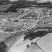
(Location cited as NO 299 014). Markinch Station, opened 1847 by the Edinburgh & Northern Railway, architect David Bell. A two-platform through station, with the main offices on the down side, in a 1- and 2-storey building above and behind the platform. The up-platform shelter is also wooden. The platforms are linked by a footbridge which is incorporated in a road overbridge.

J R Hume 1976.

Site Management (18 April 2012)

Single storey, rectangular-plan, Italianate railway station office. Single storey station office to left: advanced gable off-centre left with tripartite window, hoodmould, blind hoodmoulded oculus in gablehead; 2-leaf panelled timber door with pilaster to right on return to left. Similar door and pilaster in recessed bay to left. Modern window in altered bay to right of centre with lower roofline.

On the Forth Bridge railway line. John Balfour of Balbirnie was elected chairman of the Edinburgh and Northern Railway when it commenced at Kinghorn in 1846. The line to Cupar was opened for public travel on Monday 20 September 1847, with the highly successful official opening taking place the previous Friday "When the first train arrived at Markinch from Cupar with twenty carriages it was greeted with loud huzzas, the Old Church bell ringing a merry peal. The carriages were invaded by all and sundry... Some of the defaulters were turned out at Burntisland and had to return on their feet, to the infinite amusement of the others". (Historic Scotland)

References

MyCanmore Image Contributions


Contribute an Image

MyCanmore Text Contributions