
Knockali


Field System (Prehistoric), Hut Circle(S) (Prehistoric)
Site Name Knockali
Classification Field System (Prehistoric), Hut Circle(S) (Prehistoric)
Canmore ID 29053
Site Number NO15NW 13
NGR NO 14857 58505
Datum OSGB36 - NGR
Permalink http://canmore.org.uk/site/29053


- Council Perth And Kinross
- Parish Kirkmichael (Perth And Kinross)
- Former Region Tayside
- Former District Perth And Kinross
- Former County Perthshire
Field Visit (24 April 1974)
NO15NW 13 c.149 585.
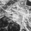
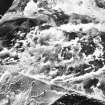
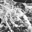
Centred at NO 149 585 is a settlement of nine stone-walled huts (A - J) with a few stone clearance heaps and ruinous walls in the vicinity from contemporary cultivation.
'A' measures 11.0m in diameter between the centres of a poorly-preserved wall with an entrance in the SSE. The E arc is disturbed by a modern wall.
'B' is oval, measuring 9.0m N-S by 7.5m between the centres of a wall spread to 2.5m, partially destroyed in the W arc. The entrance is in the S.
'C' is oval, 12.0m N-S by 10.5m between the centres of an ill-defined wall. The SW arc is mutilated and no entrance is visible.
'D' is 5.0m in internal diameter with an entrance in the SSE. Occasional inner facing stones survive in a wall of indefinite thickness. The centre is bisected by a ruinous wall built across the hut NE-SW.
'E' is a "Dalrulzian" hut, 9.0m in internal diameter and 16.5m between the centres of the outer wall. The ill- defined entrance is in the S. 'F' abuts on the W arc of 'E' and measures 11.0m in diameter between the centres of a wall of uncertain thickness. The entrance is in the SW. 'G', crossed by a modern wall, is 12.0m in diameter between wall centres. The entrance is not evident.
'H' is crossed by the same wall, and the E half is scarcely discernible. It measures c. 14.0 in diameter. No entrance evident.
'J' is 13.0m in diameter between the centres of a wall of uncertain thickness. The entrance is in the mutilated S arc.
Surveyed at 1:10,000.
Visited by OS (AA) 24 April 1974
Measured Survey (1987)
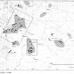
RCAHMS surveyed the hut-circles, field systems and Pitcarmick-type buildings at Drumturn Burn/Knockali in 1987 at a scale of 1:2500. The resultant plan was redrawn in ink and published at a scale of 1:5000 (RCAHMS 1990, Fig. 124.4C).
Field Visit (5 April 1988)
Situated on the W and SW slopes of Knockali there are at least nine hut-circles which form part of a larger spread of hut-circles, small cairns, banks and other buildings distributed around the W, S and E flanks of the hill.
1. NO 1470 5876 (OS 'J') The northernmost of the hut-circles on the W flank of the hill is situated on a terrace approximately 70m W of the dry-stone dyke which crosses the slope from NW to SE. It measures about 10.2m in diameter within a stony bank 2.4m in thickness and no more than 0.2m in height; the position of the entrance is uncertain but there is a 5m wide gap on the SW.
2. NO 1483 5864 (OS 'H') This hut-circle is situated on a terrace on the steep W-facing slope 160m SE of (1) and is crossed by the dry-stone dyke. It measures about 10m in diameter within a heather-covered bank up to 2.5m in thickness and 0.3m in height, the entrance is not visible. 3. NO 1486 5856 (OS 'G') This hut-circle is also crossed by the wall and is situated 90m SSE of (2); it measures about 9m in internal diameter. On the E side of the wall it is defined by a semi-circular scoop some 0.6m in depth, while on the W side of the wall there is a broad spread of rubble some 2.5m in thickness and 0.2m in height. The entrance is not visible.
4. NO 1485 5850 (OS 'E') Situated on a terrace about 30m W of the wall and 40m SSW of (3) there is a double-walled hut-circle measuring 8.4m in internal diameter and 18.6m overall. The inner wall has been reduced to a turf and heather-covered bank 2.1m thick and up to 0.4m high while the outer wall forms a bank 1.7m thick and 0.2m high from which a short length of inner facing protrudes on the E. On the E the gap between the two walls is well-defined but elsewhere it is marked only by a slight depression. The entrance is on the ESE.
5. NO 1483 5850 (OS 'F') Situated immediately WNW of (4) this hut-circle measures 8.2m in diameter within a wall reduced to a rubble bank 2.6m in thickness and 0.4m in height. There is an entrance on the SSW and on the ESE the wall is probably partly overlain by the outer wall of the double-walled hut-circle.
6. NO 1494 5837 (OS 'A') This hut-circle is situated on a low knoll immediately W of the modern dyke and is the southernmost of the group on the W flank of the hill. It measures about 8m in diameter within a wall reduced to a bank up to 3m in thickness and 0.3m in height, and there is an entrance on the SE. A number of outer facing-stones are visible.
7. NO 1493 5851 (OS 'B') Situated on the gentle W-facing slope on the E side of the modern dyke, this hut-circle measures 6.3m in diameter within a wall 2.2m in thickness and 0.4m in height. A few inner facing-stones are visible and the position of the entrance is probably marked by a depression on the S side.
8. NO 1492 5859 (OS 'D') This hut-circle has been levelled into a fairly steep S-facing slope and measures 4.7m SSE-NNW by 5.2m within a wall 1.7m in thickness and 0.4m in height. Part of an inner face of boulders and slabs set on edge survives, and the outer face is visible on the W side of the entrance, which is on the SSE. On the uphill (N) side the line of the outer face develops into an inwardly facing scarp, separated from the lower inner face by a narrow terrace up to 1.8m in breadth. The interior is crossed from NE to SW by a presumably later rubble wall.
9. NO 1495 5857 (OS 'C') This hut-circle is situated about 25m E of (8) and its interior has been levelled into the gentle SW-facing slope. It measures 9m in diameter within a wall reduced to a bank 2.7m thick and 0.4m high. On the N and E there is a discontinuous inner face of boulders and slabs but no outer face was visible. The entrance is on the S, but there appears to be another break in the wall on the NW. The hut-circle is situated on the SW side of an enclosure, whose S and W walls abut the exterior of the hut-circle.
Visited by RCAHMS (JRS) 5 April 1988.
RCAHMS 1990
Field Visit (25 November 2015)
Alder Archaeology was commissioned by John Clegg & Co, Chartered Surveyors and Forestry Agents to undertake a desk-based assessment and walkover survey on the site of a proposed forestry development at Drumfork, Blacklunans, near Blairgowrie, Perth and Kinross. The walkover (Alder site code (BW09) was done on 25 November 2015 in mainly dry, windy weather condition. The site had previously been surveyed by the RCAHMS in 1987-8 and only one additional site was recorded: a short stretch of drystone wall beside a rock outcrop, possibly part of a shelter.
Information from David Perry (Alder Archaeology Ltd).

