
Drumturn Burn


Field System (Prehistoric), Hut Circle(S) (Prehistoric)
Site Name Drumturn Burn
Classification Field System (Prehistoric), Hut Circle(S) (Prehistoric)
Canmore ID 29005
Site Number NO15NE 10
NGR NO 15890 57824
NGR Description Centred NO 160 579
Datum OSGB36 - NGR
Permalink http://canmore.org.uk/site/29005


- Council Perth And Kinross
- Parish Alyth
- Former Region Tayside
- Former District Perth And Kinross
- Former County Perthshire
Field Visit (23 April 1974)
NO15NE 10 centred 159 578.
Centred at NO 160 579 is a settlement of 16 stone-walled huts (A - Q) and a well-preserved contemporary field system.
'A' measures 9.0m in diameter within a wall spread to 2.5m. The ill-defined entrance is in the E arc.
'B', adjacent to 'A', is 14.0m in diameter between the centres of a wall poorly-preserved except to the W of the S entrance where it is spread to 3.5m.
'C' is a 'Dalrulzion' hut measuring 7.5m in diameter internally and 14.0m between the centres of the outer wall. A gap in the outer wall about 4.0m W of the SSE entrance is uncertainly a mutilation or an original entrance way into the annular space.
'D' is a 'Dalrulzion' hut set well into the steep SW slope. It measures 9.5m N-S by 8.5m E-W internally and 14.5m between the centres of the outer wall. The central area is eccentrically placed so that the space between the walls increases to 4.0m in the E. In the W arc the walls are joined to make one solid wall.
'E' is a 'Dalrulzion' hut 9.0m in diameter internally and 14.5m between outer wall centres, with a well-preserved SSE entrance.
'F' is a small single-walled circle 6.5m in diameter between the centres of a wall spread to 2.0m with an ill-defined entrance in the NW. A wall runs from the W arc to join the wall of hut 'E' just to the W of the entrance, and another runs from the E arc to join the W arc of hut 'H'. 'G' is a 'Dalrulzion' hut 8.5m in diameter internally and 15.0m between outer wall centres with a S entrance.
'H' is a 'Dalrulzion' hut 7.0m in diameter internally and 14.0m between outer wall centres with a SSE entrance.
'J' is an ill-defined 'Dalrulzion' hut with a scarcely visible inner area c. 7.5m in diameter, and a diameter of 15.0m between outer wall centres. SSE entrance.
'K' is an ill-defined single-walled hut c. 8.0m in diameter with the entrance in the WSW.
'L' is 13.5m between the centres of a mainly ill- defined wall spread to 2.0m in the S. The wall is destroyed in the N. Entrance in SSE.
'M' is 11.0m between the centres of a wall spread to 2.5m and partially destroyed in the W. The ill-defined entrance is in the S.
'N' and 'O' are a double 'Dalrulzion' complex of unusual plan (see enlargement).
'P' is a 'Dalgulzion' hut with an oval annexe adjoining the E arch (see enlargement).
'Q' is a 'Dalrulzion' hut of unusual plan (see enlargement).
'R' is a strong walled enclosure, uncertainly a hut, measuring 7.0m N-S by 6.0m E-W between the centres of a wall spread to 3.0m. No entrance is evident.
'S' is a similar strong enclosure 7.5m in diameter between the centres of a wall spread to 3.0m, with no entrance evident.
The field system is marked by numerous irregular walls, lynchets and some stone clearance heaps. There are suggestions of trackways between the fields and gaps in the walls suggesting gateways.
Surveyed at 1:10,000.
Visited by OS (AA) 23 April 1974
Field Visit (August 1987)
This large group of hut-circles and fields extends across the SW flank of Beddingrew to the W of Drumturn Burn. At least twenty-two hut-circles and a platform can be identified and these are described from N to S.
1. NO 1591 5814 (OS 'A') Situated on gently sloping ground, this hut-circle measures 8.3m in internal diameter and its entrance is on the S. Its wall has been reduced to a bank of rubble up to 1.7m thick by 0.3m high on the N, developing into a scarp 0.5m high internally on the E and 0.7m high externally on the W. A large inner facing stone survives to the E of the entrance. The E side of the hut-circle is skirted by a hollowed trackway.
2. NO 1590 5814 (OS 'B') What is probably an earlier hut-circle lies immediately down the slope to the W. It measures about 11.5m in internal diameter, but its wall has been reduced to an arc of bank 2.7m thick by 0.3m high internally around the W and a scarp up to 0.5m high on the NE. On the downslope side to the W the bank forms a scarp up to 0.6m high.
3. NO 1596 5803 (OS 'C') Situated on a terrace above the rest of the hut-circles, this double-walled example measures 7.9m from N to S by 7m internally and 14.2m in diameter overall. The inner wall is about 1.3m thick by 0.2m high, many of its inner facing-stones, boulders up to 1.3m long by 0.6m high, surviving in situ; on the W there are also a series of possible outer facing-stones. The outer wall has been reduced to a stony bank about 1.2m thick by 0.3m high, but a few outer facing-stones are visible to either side of the entrance, which is on the S. On the W there is a space 1.5m wide between the two walls, but on the E the gap has been filled to form a flat terrace between innermost facing-stones and the top of the outer wall. The entrance passage splays from about 1.3m wide at the inner end, where two facing stones have collapsed inwards, to 3.7m at the outer end.
4. NO 1603 5785 (OS 'H') Situated on sloping ground, the interior of this double-walled hut-circle has been dug up to 0.7m into the slope on the E. Internally it measures 6.6m in diameter, and overall 15.4m. Around the W the inner wall has been reduced to a stony bank 1.6m thick and 0.3m high, and around the E it forms a scarp 0.7m high. The outer wall forms a stony bank about 1.3m thick, but numerous large boulders, some up to 0.6m high, along its outer edge probably mark the course of the outer face. The gap between the two walls is about 1.5m wide and forms a raised terrace on the uphill side. The entrance passage is on the SSE and splays from 1m at the inner end to 3.1m at the outer.
5. NO 1599 5789 A house platform about 8m across is set at the foot of a steep scarp 60m NW of (4) immediately upslope from (7). On the E the back of the platform has been dug about 0.6m into the slope, and on the W the scarp at the front is a maximum of 0.7m high.
6. NO 1598 5786 (OS 'F') This small hut-circle lies on the line of a field-bank with its entrance facing WNW into the trackway that leads down from (4) to (7) and (8). It measures about 4.9m in diameter within a stony bank up to 1.9m thick by 0.5m high. A line of five inner facing-stones survives to the S of the entrance, and a few large boulders visible around the outer edge of the bank may belong to the outer face.
7. NO 1596 5789 (OS 'D') An eccentrically shaped double-walled hut-circle, its interior measuring 9.3m in diameter and dug up to 0.5m into the slope on the E. On the E the inner wall is reduced to a stony scarp, but on the W where five inner facing stones survive, its core merges with that of the outer wall to give an overall thickness of 2.4m; the outer edge of this merged wall is marked by a line of large boulders, set some 0.9m below the level of the interior. On the N the outer wall detaches from the inner, and forms a bank about 1.4m thick, with a few outer facing stones visible along its outer edge. The space between the two walls, which also appears to have been levelled into the slope, expands from 2m on the N to 4.3m on the E side of the entrance. The entrance, which is on the SSE, is about 1.9m wide at its inner end, which is virtually parallel sided for a distance of 1.7m towards the outside.
8. NO 1595 5787 (OS 'E') This double-walled hut-circle, which lies immediately SSW of (7), measures 8.6m in diameter internally and 16.2m overall. The interior has been dug into the slope on the E to a depth of at least 0.6m. The core of the inner wall forms a bank 1.2m thick, but twenty inner facing stones are visible, the tallest up to 0.7m high, and rising up above the top of the core. The outer wall has been reduced to a stony bank about 1.7m thick and the boulders that lie along its outer edge probably formed the outer face; on the W it drops down the slope to a maximum 0.7m below the level of the interior. The entrance, which is on the SSE, is lined with facing-stones and splays from 1.1m at the inner end to 2.9m at the outer.
9. NO 1597 5783 This possible hut-circle lies in one of the fields to the SSE of (8); only the N half of the hut-circle is visibe, and it has been reduced to a stony bank 3.5m thick, with an overall diameter of about 13.6m.
10. NO 1591 5788 (OS 'G') This double-walled hut-circle measures 8m in diameter internally and 16.5m from WSW to ENE by 15.8m overall. The inner wall has been reduced to a stony bank 1.6m thick by 0.2m high from which fourteen facing-stones protrude, the tallest about 0.7m high. The outer wall forms a stony bank about 1.1m thick by 0.2m high and a few possible outer facing-stones are visible around the circuit. The space between the two walls is about 2m wide. The entrance, which is on the SSE, has six facing-stones on the E side and two on the W side, and it splays from 1.5m wide at the inner end to 4.2m at the outer end. Immediately SW of the hut-circle there is a small angular platform; a few boulders protrude through its leading edge, which is about 0.4m high. Its date and purpose are unknown.
11. NO 1589 5782 (OS 'J') The remains of what is probably a double-walled hut-circle lies 50m SSW of (10). It measures about 7.5m in diameter internally and about 16m overall. It has been completely wrecked by stone-robbing, however, and the inner wall has been reduced to a scarp no more than 0.2m in height on the E, and a low mound of rubble 1.8m thick on the N. On the W the cores of both walls merge, with an overall thickness of 4.5m and a line of large boulders probably marking the course of the outermost wall-face. Elsewhere the outer wall has been reduced to a low bank 1.5m thick or, on the E, a scarp about 0.3m high. The entrance, which is on the SSE, is at least 1.5m wide. 12. NO 1591 5777 (OS 'N') This hut-circle is the westerly of a pair enclosed by a wall which appears to post-date the establishment of a trackway leading down to (11). The hut-circle measures 9.5m from N to S by 9.3m internally; its wall is 1.1m thick and comprises an almost complete ring of inner facing-stones, some up to 0.6m high, backed by a mound of rubble. The interior has been dug into the slope to a depth of about 0.5m on the E, where the top of the wall forms a terrace at the foot of the adjoining hut-circle wall. The entrance, which is on the SSE, is about 1.2m wide and splays externally; at this point the gap between the enclosure wall and hut-circle is filled with stones.
13. NO 1573 5777 (OS 'O') The interior of the easterly hut-circle measures 9.3m from N to S by 8m transversely and has been dug into the slope to a maximum depth of 0.4m on the E. Its wall has largely been reduced to a stony bank 2m thick by 0.3m high, but seven inner facing-stones are still visible. Except where it dog-legs back to meet the earlier trackway on the N, the enclosure wall lies about 1.7m beyond the walls of the two hut-circles; it measures from 1.4m to 2m in thickness and has been faced externally, the facing-stones being particularly noticeable to the SE of the easterly hut-circle.
14. NO 1595 5777 (OS 'P') Immediately to the E of (12) and (13) there is another pair of hut-circles, which appear to have been built across the line of the trackway. The interior measures about 7.3m in diameter and has been dug into the slope on the E, where the wall forms a scarp 0.6m in maximum height. Elsewhere the wall has been reduced to a stony bank 1.5m thick. Three inner facing-stones are still visible. The entrance is on the S. Around the W a thick band of stones appears to have piled up against the hut-circle, reducing the gap between this and the enclosure around the neighbouring hut-circle; it may be part of an outer wall, but it fades out to the N, simply forming a stony spread across the trackway.
15. NO 1595 5777 (OS 'P') The easterly of the pair is smaller, its oval interior only measuring 4.6m from NNE to SSW by 3.8m transversely. Its wall has been reduced to a stony bank 2m thick by 0.3m high externally and 0.9m high internally. The entrance, which is on the SSW, is flanked by possible facing-stones and is 1.2m wide.
16. NO 1596 5776 (OS 'Q') The trackway that is overlain by hut-circles (14 and 15) continues SE, running between a positive lynchet on the NE and an unusual double-walled hut-circle on the SW. The hut-circle measures 6.9m in internal diameter; its inner wall comprises a ring of large facing stones up to 0.5m in height, seventeen of which survive, backed by a mound of rubble. The entrance, which is on the SSE, is about 1.3m wide, splaying externally where the outer wall springs to form an eccentric enclosure around the hut-circle. Although a few outer facing-stones are visible, mostly to the W of the entrance, the outer wall has been reduced to a stony bank about 1.3m thick by 0.3m high, the gap between the two walls expanding from 1.7m around the W to a maximum of 7.2m on the E side of the entrance.
17. NO 1596 5774 (OS 'R') A possible hut-circle lies at the N end of a field-bank immediately S of (16). It measures 5.3m from N to S by 3.9m within a bank of stones up to 2m in thickness by 0.5m in height. No entrance is visible.
18. NO 1594 5774 (OS 'S') A second possible hut-circle lies to the W of (17). Overall it measures 9.3m from E to W by 8.8m transversely, but the interior is markedly more oval, measuring 4.8m by 3.9m. There is a gap in the bank, which is up to 2.8m thick by 0.4m high, on the E.
19. NO 1585 5777 (OS K') At the foot of the slope to the W there is a row of at least three hut-circles. The northernmost measures about 9.3m in diameter overall, but there is little trace of its bank, which is up to 1.6m thick by no more than 0.2m high, on the NE. The entrance is on the SW.
20. NO 1585 5775 (OS 'L') This hut-circle, the middle one of the three, measures 9.3m in internal diameter and its entrance is on the S. Around the E its bank is 2.2m thick by 0.4m high, but on the N and W it has been reduced to little more than a scatter of stones.
21. NO 1586 5773 (OS 'M') The southernmost hut-circle measures about 8.5m in internal diameter. Around the NE the wall has been reduced to a stony bank 2.1m thick by 0.4m high, but elsewhere little trace of it can be seen in the heather; a depression on the SSW probably marks the position of the entrance.
22. 23. NO 1587 5774 Immediately to the NE of (21) there are traces of a pair of hut-circles set close together. Their walls have been almost totally robbed, but the arcs of their uphill sides are preserved in the leading edge of a field on the slope immediately to the NE. The southerly of the pair measures 4m in internal diameter and the entrance was on the W where there is now a large gap 2.6m wide. Where best-preserved its bank is about 1.8m thick by 0.3m high. The northerly hut-circle which has been more severely robbed, measures about 4.7m in internal diameter; its E side is bounded by a stony scarp about 0.5m high, which forms part of the field boundary, but elsewhere all that survives of its perimeter is two low banks separated by a shallow groove 0.8m broad. The entrance was probably on the SSE.
Visited by RCAHMS (SPH) August 1987
RCAHMS 1990.
Measured Survey (1987)
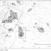
RCAHMS surveyed the hut-circles and field system at Drumturn Burn in 1987 by self-reducing alidade and plane-table at a scale of 1:1250. The resultant plan was redrawn in ink and published at a scale of 1:2500 (RCAHMS 1990, Fig. 124.10C).
Measured Survey (18 May 1988)
RCAHMS surveyed a hut-circle at Drumturn Burn by self-reducing alidade and plane-table on 18 May 1988 at a scale of 1:250 (D: NO 15968 57758). The resultant plan was redrawn in ink and published at a scale of 1:500 (RCAHMS 1990, Fig. 124.10B).
Measured Survey (18 May 1988)
RCAHMS surveyed a pair of the hut-circles at Drumturn Burn by self-reducing alidade and plane-table on 18 May 1988 at a scale of 1:250 (B: NO 15919 57768). The resultant plan was redrawn in ink and published at a scale of 1:500 (RCAHMS 1990, Fig. 124.10A).
Field Visit (25 November 2015)
Alder Archaeology was commissioned by John Clegg & Co, Chartered Surveyors and Forestry Agents to undertake a desk-based assessment and walkover survey on the site of a proposed forestry development at Drumfork, Blacklunans, near Blairgowrie, Perth and Kinross. The walkover (Alder site code (BW09) was done on 25 November 2015 in mainly dry, windy weather condition. The site had previously been surveyed by the RCAHMS in 1987-8 and only one additional site was recorded: a short stretch of drystone wall beside a rock outcrop, possibly part of a shelter.
Information from David Perry (Alder Archaeology Ltd).

