
Pricing Change
New pricing for orders of material from this site will come into place shortly. Charges for supply of digital images, digitisation on demand, prints and licensing will be altered.
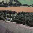
Bunchrew


Pile(S) (20th Century), Slipway (21st Century)
Site Name Bunchrew
Classification Pile(S) (20th Century), Slipway (21st Century)
Canmore ID 287214
Site Number NH64NW 110
NGR NH 6220 4599
NGR Description NH 620 460 to NH 622 459
Datum OSGB36 - NGR
Permalink http://canmore.org.uk/site/287214


- Council Highland
- Parish Kirkhill
- Former Region Highland
- Former District Inverness
- Former County Inverness-shire
NH64NW 110 622 459
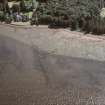
5 small posts, 2 square and 2 quartered and 1 severly eroded/burnt. 2 look burnt at surface.
Slipway c 1.5m wide and 10-15m long. Concrete sides and centre wooden runners c 0.15 by 0.1m Extends from high water mark to mud.
CFA/MORA Coastal Assessment Survey 1998

