
Law Hill, Arnbathie


Chevaux De Frise (Prehistoric), Fort (Prehistoric), Hut Circle(S) (Prehistoric)
Site Name Law Hill, Arnbathie
Classification Chevaux De Frise (Prehistoric), Fort (Prehistoric), Hut Circle(S) (Prehistoric)
Canmore ID 28116
Site Number NO12NE 2
NGR NO 17031 25894
Datum OSGB36 - NGR
Permalink http://canmore.org.uk/site/28116


- Council Perth And Kinross
- Parish Kilspindie
- Former Region Tayside
- Former District Perth And Kinross
- Former County Perthshire
One black and white photograph of Perthshire Scientific & Natural History Society excavations of a hut circle below the fort has been donated to the Perth Museum and Art Gallery Accession no 1988.88.1.
Information from A G Reid (Perth Museum) 1988.
NO12NE 2 1703 2589.
For cairn on the highest point of the interior, see NO12NE 43. For a crude pottery vessel, a flint scraper and a complete tuyere (RMS EQ 564-5, and CM 40 respectively) found by quarrying in the hill, see NO12NE 3.
See also NO12NE 4 and NO12NE 38 for adjacent hut-circle, building and enclosure.
Field Visit (29 August 1953)
(NO 170 259) Iron Age contour hill fort, 600 feet by 446 feet, with two external hut circles (A and B), 18 feet and 40 feet respectively, protected by steep natural slopes on all sides except the north. Here there are three ramparts. The innermost seems to have a foundation of stone and facing stones on each side. The entrance lies immediately east of the triple rampart and runs in along the rocky edge towards the east. Beyond the walls, on the easy north slope, are many placed stones forming a chevaux de frise. North of these were two further banks, now levelled, but there was no sign of ditch here. Some one hundred yards west of the entrance there seems to have been a waterhole which is still swampy and rush-grown. At the highest point of the hill is a mound or tumulus, 27 feet across. Its outline is indistinct but it seems to have been made up,at least on the west side.
R R B Watson 1929; Information from M E C Stewart 29 August 1953.
Field Visit (20 July 1956)
Fort, Law Hill
An important, though much wasted, multi-walled contour fort of Kaimes Hill type. As it is not on the Ordnance Survey map, a plan should be made for record purpose s as soon as possible , but good air-photographs are required t o elucidate the situation at the northern end where there appear to be at least 6 lines of defence, i.e. triple walls and a series of 3 earthen ramparts outside them. The hut circles pencilled in on the 6-in OS map are stone-walled and measure up to 40 ft in diameter internally. They are so widely scattered, however, that it is doubtful if they have any connection with the fort (which itself shows no trace of dwellings). The excavation of one of these huts by Mrs Stewart is referred to, under Arnbathie, in the Scottish Regional Group’s Annual Report for 1950.
Visited by RCAHMS (KAS) 20 July 1956
Field Visit (9 October 1963)
NO 170 258. The fort is generally as described above. The encircling rampart has an average external height of 0.2m and where evident on the east and west its interior height is 0.3m. At least 100 stones remain of the chevaux-de-frise on the north side of the fort. The mound on the highest point of the interior is 7.0m diameter and although grass covered it appears to be composed of earth; there is no evidence of a kerb. Nothing was seen of the water-hole (R R B Watson 1929; information from M E C Stewart 29 August 1953) save for an area of marshy ground.
Of the two hut circles mentioned by the Authorities only 'B' was located. It is a circular enclosure 12.0m in diameter and lies at a much lower level some 40.0m SE of the SE side of the fort. It is bounded by a grassy scarp save on the south side where there is a bank 0.5m high; no entrance was noted. This enclosure may be an old sheepfold possibly associated with the building outline c 66.0m to the NE (see NO12NE 4) Surveyed at 1:2500.
Visited by OS (E G C) 9 October 1963.
Field Visit (8 June 1989)
This large multi-period fort occupies the top of Law Hill, Arnbathie, an inconspicuous hill on the NW flank of the Sidlaws. Roughly oval on plan, the fort measures about 154m by 90m within a heavily-robbed wall (now overlain by an old dyke) which measures up to 6m in thickness and 0.4m in height, and is pierced by four entrances (on the N, S, E and W). This wall represents the latest in a complex sequence of defences, which cannot be fully disentangled without excavation, but has probably comprised at least three phases.
Evidence for multi-phase construction can be seen most readily on the exposed N approach to the hill, between the N and W entrances. What is probably a fragment of the earliest defensive system comprises the remains of the three outermost ramparts on this side, which may have been outworks protecting a line of defence now buried beneath the inner defences. Subsequently, these outer ramparts were superceded by a short length of rampart which enhances the defences at the N entrance, and also by a rampart which forms a complete circuit outside the inner wall and must belong with the later phases of defence. A further rampart on the S has been partly destroyed by quarrying and encloses a terrace to form an annexe containing a stone-walled hut-circle with an entrance on the SSW. Additional protection in the later periods of defence was provided by a chevaux de frise which partly overlies the ramparts of the early defensive system on the N.
The four entrances to the fort are all approached along well-defined trackways. That the N entrance provided the principal access to the fort is suggested by several attendant features, viz. the thickening of the inner wall, the chevaux de frise, the ramparts, and the broad, stone-lined trackway. The S gateway appears to be blocked by a thin band of stone, but this may be no more than tumble from the adjacent wall. The W entrance is the most complex, combining elements from several phases of construction. On the S side of the gateway (which is particularly narrow) the inner wall is slightly out-turned, lying over a short stretch of earlier walling, and the trackway itself appears to be flanked by stretches of walling.
The interior of the fort has been cultivated, but a cairn (NO12NE 43) survives on the highest point, and a depression, situated to the NW, may mark the site of a pond or cistern.
Visited by RCAHMS (JRS) 8 June 1989.
Measured Survey (5 June 1991 - 6 June 1991)
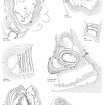
RCAHMS surveyed the fort at Law Hill, Arnbathie (NO12 NE 2) with plane-table and self-reducing alidade between 5-6 June 1991 at a scale of 1:500. The resultant plan was redrawn in ink as part of a ‘Comparative plans of upstanding forts’ illustration and published at a scale of 1:2500 (RCAHMS 1994b, 53).
Field Visit (1997)
NO 170 258 Two hut circles on the SE slopes of Law Hill above Scone were surveyed in December 1996; they may be associated with the existing hillfort and previously recorded settlement 1km to the N. The structures were of 8.2m and 12.3m maximum diameter.
I Hallyburton 1997.
Note (8 May 2015 - 18 October 2016)
This fort occupies the broad summit of Law Hill W of Arnbathie. Oval on plan, it measures 154m from N to S by 90m transversely (1ha) within a heavily robbed rampart overlain by an old field-dyke that follows the shoulder of the summit. Representing the natural line of defence, where the ground falls away more steeply on all sides, but particularly on the W, this probably always formed the innermost circuit of defence, but on the N, where access was easiest, there are up to five outer ramparts, probably representing several periods of construction, though their precise sequence and chronology are unknown. Elsewhere, traces of a single outer rampart are visible around most of the circuit, and on the S a separate outwork appears to have taken in a lower terrace occupied by a single hut-circle. Trackways mount the slope obliquely through entrances on the N, E, S and W, and while three expose the righthand side of the visitor, that on the W exposes the lefthand side. The N entrance, where the sinous trackway is lined with stones, was also defended by a chevaux de frise, which seems to have acted in unison with the outermost ramparts to confined approaching traffic to the edge of a natural escarpment falling away to the E. The interior, at least part of which has been cultivated, is largely featureless, but a damp hollow on the NW is possibly a pond or cistern, and what may be an earlier cairn about 7m in diameter by 0.5m stands on the very summit.
Information from An Atlas of Hillforts of Great Britain and Ireland – 18 October 2016. Atlas of Hillforts SC3037

