
Pricing Change
New pricing for orders of material from this site will come into place shortly. Charges for supply of digital images, digitisation on demand, prints and licensing will be altered.
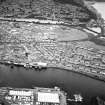
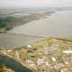
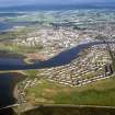
Inverness Harbour, Thornbush Quay


Quay (Period Unassigned)
Site Name Inverness Harbour, Thornbush Quay
Classification Quay (Period Unassigned)
Alternative Name(s) River Ness; Inner Moray Firth
Canmore ID 279993
Site Number NH64NE 129.03
NGR NH 6598 4660
NGR Description Centred NH 6598 4660
Datum OSGB36 - NGR
Permalink http://canmore.org.uk/site/279993


- Council Highland
- Parish Inverness And Bona
- Former Region Highland
- Former District Inverness
- Former County Inverness-shire
NH64NE 129.03 centred 6598 4660
Thornbush Quay [NAT] (name centred NH 6598 4660)
OS 1:10,000 map, 1992.
For shipyard, crane and sheerlegs at Thornbush Quay (centred NH 6610 4645), see NH64NE 128.00.
For pillbox at NT 65935 46645, see NT64NE 750.
Publication Account (2007)
Thornbush Quay on the west bank [of the Ness] was begun in 1813 and completed in 1817. The work was done under Telford’s direction by Thomas Hughes using the unusual and economical expedient of building the masonry under water [Weale, 1843].
In 1908 a new boat slipway was built at Thornbush Quay. This offered ship repair facilities for drifters and trawlers and encouraged small-scale shipbuilding, services much used during the first and second world wars and still in use.
Further expansion of the harbour took place in 1985 with the construction opposite Thornbush Quay of the 600 ft long Longman Quay.
R Paxton and J Shipway, 2007.
Reproduced from 'Civil Engineering heritage: Scotland - Highlands and Islands' with kind permission from Thomas Telford Publishers.

