
Port Odhar


Building (Period Unassigned), Enclosure(S) (Period Unassigned), Farmstead (Period Unassigned), Lazy Beds (Post Medieval), Pen (Period Unassigned)
Site Name Port Odhar
Classification Building (Period Unassigned), Enclosure(S) (Period Unassigned), Farmstead (Period Unassigned), Lazy Beds (Post Medieval), Pen (Period Unassigned)
Canmore ID 272930
Site Number NC37SE 5
NGR NC 35592 71009
Datum OSGB36 - NGR
Permalink http://canmore.org.uk/site/272930


- Council Highland
- Parish Durness
- Former Region Highland
- Former District Sutherland
- Former County Sutherland
NC37SE 5 35592 71009
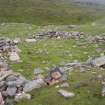
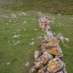
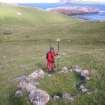
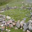
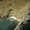
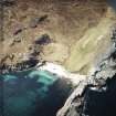
NC 35600 70952. A large dry stone building is situated at the base of the hill. The structure is fairly substantial. The feature is overgrown by bracken and scrub. It could not clearly be identified or dated. However it is clear from the structure that it was definately a dwelling of some sort. There appears to be stone partitions. which suggest the presence of chambers. It may be some sort of farmstead or fisherman's cottage given the geography of the area and the natural harbour at Port Odhar? The building is not rectangular and curves in places, this may well be intended. This curvature does not seem to be the result of wall collapse given the solidness of the remaining foundations. The building was recorded and measured in plan.
Street 2001, 16.
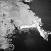
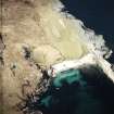
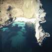
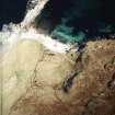
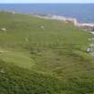
The remains of lazy-beds and enclosures have been recorded on oblique aerial photography (RCAHMSAP 2004) lying on the shore at Port Odhar. Two conjoined enclosures lie immediately to the W of the fragmentary remains of lazy-beds. A third curvilinear enclosure can be seen lying to the E.
Information from RCAHMS (KMM) 21 April 2005.
Field Visit (2008)
NC37SE 5 35592 71009
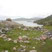
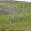
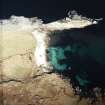
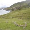
This farmstead is situated at Port Odhar (NC37SE 2), a sandy cove which provides a naturally sheltered landing place for boats. The extent of the farmstead, including its cultivated ground, is defined on the NE and SE by the shore, on the NW and W by a stone wall (CWTC08 418 & 419) and on the SW by a combination of the continuation of that stone wall and steep natural slopes. Within this area, which measures some 6.5 ha (c.16 acres), there is a building (CWTC08 62), a hut (CWTC08 60), which is attached to an enclosure (CWTC08 297), a small oval detached enclosure or pen (CWTC08 318), two detached enclosures (CWTC08 58 & 59), and an area of lazy-bed cultivation, which lies to either side of the stream that flows through the site and into the sea. Short lengths of stony bank (CWTC08 419 & 420), which lie within the area defined by the stone wall on the NW and W, may be contemporary with them or they may indicate an earlier phase of land division.
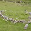
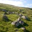
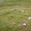
The only substantial building (CWTC08 62) within the farmstead stands in a roughly oval enclosure (CWTC08 386) on a rocky shelf overlooking the cove from the SW. Heavily obscured by bracken on the date of visit, it measures about 7.8m from E to W by 3.2m transversely over a stone wall up to 1m in thickness at the base and 0.6m in height. It comprises at least two compartments, but they are probably of different periods, the E one appearing to butt onto the W one. A small pen (CWTC08 386) lies within the S end of the enclosure. The hut (CWTC08 60) is situated on a NE-facing slope 30m N of the building. Oval on plan, it adjoins the E side of an enclosure (CWTC08 297), which has a broad entrance in its W side. A small oval enclosure or pen (CWTC08 318) stands some 30m W of this enclosure (Fig.46).
The two detached enclosures are situated to the NE of the stream, the first (CWTC08 58) in the lee of a large boulder on the summit of the low ridge between the farmstead and the sea to the NW, and the second (CWTC08 59) a short distance above the stream. Oval on plan and measuring no more than 8.7m in internal diameter, both enclosures comprise boulder rubble walls with narrow entrances.
The lazy-beds (CWTC08 435) occupy the sloping ground behind the beach and to either side of the stream that cuts through the area from NW to SE. They measure about 3m in breadth and from 7m to 42m in length. Generally they are well-defined, but some have been damaged by bombs and shells, the craters of which pock-mark the entire area of the farmstead and its enclosed ground.
'Portover' is one of three farmsteads noted as being situated on the W side of the Kyle of Durness in a list of farmsteads in Durness parish compiled in 1726 (Mitchell 1906, 193). However, it is not depicted on Roy’s Military Map (1747–55), show on any later maps, or mentioned in the entry for Durness parish in the Statistical Account (1792, volume iii, 576-85).
CWTC08 58–60, 62, 296–7, 318, 386, 418–21, 435).
Visited by RCAHMS (JRS, JH) 10 August 2008.
Field Visit (2008)
NC37SE 5 35592 71009
This farmstead is situated at Port Odhar (NC37SE 2), a sandy cove which provides a naturally sheltered landing place for boats. The extent of the farmstead, including its cultivated ground, is defined on the NE and SE by the shore, on the NW and W by a stone wall (CWTC08 418 & 419) and on the SW by a combination of the continuation of that stone wall and steep natural slopes. Within this area, which measures some 6.5 ha (c.16 acres), there is a building (CWTC08 62), a hut (CWTC08 60), which is attached to an enclosure (CWTC08 297), a small oval detached enclosure or pen (CWTC08 318), two detached enclosures (CWTC08 58 & 59), and an area of lazy-bed cultivation, which lies to either side of the stream that flows through the site and into the sea. Short lengths of stony bank (CWTC08 419 & 420), which lie within the area defined by the stone wall on the NW and W, may be contemporary with them or they may indicate an earlier phase of land division.
The only substantial building (CWTC08 62) within the farmstead stands in a roughly oval enclosure (CWTC08 386) on a rocky shelf overlooking the cove from the SW. Heavily obscured by bracken on the date of visit, it measures about 7.8m from E to W by 3.2m transversely over a stone wall up to 1m in thickness at the base and 0.6m in height. It comprises at least two compartments, but they are probably of different periods, the E one appearing to butt onto the W one. A small pen (CWTC08 386) lies within the S end of the enclosure. The hut (CWTC08 60) is situated on a NE-facing slope 30m N of the building. Oval on plan, it adjoins the E side of an enclosure (CWTC08 297), which has a broad entrance in its W side. A small oval enclosure or pen (CWTC08 318) stands some 30m W of this enclosure (Fig.46).
The two detached enclosures are situated to the NE of the stream, the first (CWTC08 58) in the lee of a large boulder on the summit of the low ridge between the farmstead and the sea to the NW, and the second (CWTC08 59) a short distance above the stream. Oval on plan and measuring no more than 8.7m in internal diameter, both enclosures comprise boulder rubble walls with narrow entrances.
The lazy-beds (CWTC08 435) occupy the sloping ground behind the beach and to either side of the stream that cuts through the area from NW to SE. They measure about 3m in breadth and from 7m to 42m in length. Generally they are well-defined, but some have been damaged by bombs and shells, the craters of which pock-mark the entire area of the farmstead and its enclosed ground.
'Portover' is one of three farmsteads noted as being situated on the W side of the Kyle of Durness in a list of farmsteads in Durness parish compiled in 1726 (Mitchell 1906, 193). However, it is not depicted on Roy’s Military Map (1747–55), show on any later maps, or mentioned in the entry for Durness parish in the Statistical Account (1792, volume iii, 576-85).
CWTC08 58–60, 62, 296–7, 318, 386, 418–21, 435).
Visited by RCAHMS (JRS, JH) 10 August 2008.

