
Following the launch of trove.scot in February 2025 we are now planning the retiral of some of our webservices. Canmore will be switched off on 24th June 2025. Information about the closure can be found on the HES website: Retiral of HES web services | Historic Environment Scotland
Dunkeld, Bridge Street, Dunkeld Bridge


Road Bridge (19th Century)
Site Name Dunkeld, Bridge Street, Dunkeld Bridge
Classification Road Bridge (19th Century)
Alternative Name(s) River Tay
Canmore ID 27189
Site Number NO04SW 34
NGR NO 02675 42453
Datum OSGB36 - NGR
Permalink http://canmore.org.uk/site/27189


- Council Perth And Kinross
- Parish Dunkeld And Dowally
- Former Region Tayside
- Former District Perth And Kinross
- Former County Perthshire
NO04SW 34 02675 42453
Dunkeld Bridge [NAT]
OS 1:10,000 map, 1983.
Location formerly cited as NO 0267 4252 to NO 0268 4236.
See also NO04SW 37 and NO04SW 46.
For adjacent tollhouse (NO 0269 4234), see NO04SW 49.
Built 1806-8, Thomas Telford, engineer.
L T C Rolt 1958.
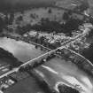
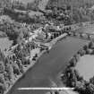
(Location cited as NO 027 424). Dunkeld Bridge, built 1805-9 by engineer Thomas Telford. A superbly situated 7-span rubble bridge, 685 ft (209m) long, with segmental arches.
J R Hume 1977.
This bridge carries the A 923 public road across the River Tay to the S of Dunkeld (NO04SW 37), where it forms a southward continuation of Bridge Street. The river here forms the boundary between the parishes of Dunkeld and Dowally (to the N) and Little Dunkeld (to the S).
The location assigned to this record defines the midpoint of the structure. The available map evidence suggests that it extends from NO c. 02675 42532 to NO c. 02676 42367.
Information from RCAHMS (RJCM), 31 May 2006.
NMRS REFERENCE:
Earlier Bridge by Alexander Mylne, 1510.
Architect: Thomas Telford, 1810.
John Simpson - Built by John Simpson (1755-1815) under Thomas Telford's direction between 1806-1808.
EXTERNAL REFERENCE:
SCOTISH RECORD OFFICE
Building a bridge over the River Tay.
Memorial by noblemen and gentlemen of the County of Peth for assistance from the forfeited estates fund for building a bridge over the Tay at Dunkeld, 1784.
GD 51/5/549/2.
Bridge across the River Tay at Dunkeld.
Letters (2) from the Duke of Atholl to Sir George Steuart. The concern suitable stone and quarries, 1803 and 1804.
GD 121/Box/103/vol xxvii/192 and 213.
NMRS REFERENCE:
Print Room
W Schomberg Scott Photograph Collection, Acc no 1997/39.
2 prints of Cathedral Street from behind the Cathedral gates.
(Undated) information in NMRS.
Construction (1808)
Designed by Thomas Telford. Built 1804-08. Largest of his Scottish bridges. Carried the Perth to Inverness road over the Tay. Bypassed by new A9 in 1977.
R Paxton and J Shipway 2007
Photographic Survey (1955)
Photographs of buildings in Dunkeld, Perthshire, by the Scottish National Buildings Record in 1955.
Publication Account (1987)
This bridge is one of Thomas Telford's outstanding monuments. Telford was an engineer of genius and one of the first to undertake road building on a massive scale. In 1803 he was appointed surveyor and engineer to the newly-created Commission for Highland Roads and Bridges. He held this post for eighteen years and during that time was responsible for 1,470km of new road and over a thousand bridges. His roads set new standards in surfacing and the bridges varied in scale from mere culverts to some very large spans of iron or masonry.
Dunkeld Bridge is 208m long and 8m wide and was built in 1809 as a toll-bridge. The toll-house at the south end of the bridge brought objections from the townspeople of Dunkeld from its inception. The problem became even more acute after the opening of the Dunkeld and Perth Railway in 1856 as the station was on the south side of the river and the toll had to be added to the cost of rail travel. In 1868 there were 'toll riots' in Dunkeld and a detachment of Royal Highlanders were sent to keep the peace. On several occasions the toll-gates were removed and thrown into the river. The bridge was eventually taken over by the County Council in 1879. The toll-house still survives on the eastern side of the south abutment The town lock-up occupied the chamber within the north abutment.
Telford employed a very distinctive toll-gate constructed of wrought-iron straps forming a double sunburst pattern, the straps radiating like the rays of the sun from two quadrants, one in each of the two hinged corners of the gate. A gate of this design can be seen at Cortachy Castle (NO 394592), but it is not known whether it is an original Telford gate or a later copy.
Dunkeld is now by-passed by the A 9 trunk road and the reduction in traffic within the town presents the opportunity to stop and examine this fine monument Dunkeld Cathedral (NO 024425) and the NTS restoration of the High Street and Cathedral Close are also worthy subjects.
Information from ‘Exploring Scotland’s Heritage: Fife and Tayside’, (1987).
Project (2007)
This project was undertaken to input site information listed in 'Civil engineering heritage: Scotland - Lowlands and Borders' by R Paxton and J Shipway, 2007.
Publication Account (2007)
This magnificent bridge is a good example of Telford’s dictum that in a bridge of multiple arches the spans
should increase slightly towards the centre and the roadway parapet line seen in elevation should be on the
arc of a great circle from one abutment to the other. It is Telford’s largest Scottish bridge and its functionality
is enhanced by modest embellishment in his favourite Gothic style which is successful in harmonising
with its dramatic surroundings.
Construction began in 1804, the main contractor being John, Duke of Atholl, and the bridge was opened in
November 1808. It cost ‘above £30 000’. Until Dunkeld was bypassed by the new A9 road in 1977, the bridge
carried the A9 Perth to Inverness road over the Tay. It now serves mainly local and tourist traffic.
The width of the river at this point and its shallowness allowed the bridge to be constructed in two halves, each
half being built in a dry channel while the river flow was diverted into the other.
The bridge, about 685 ft long, has seven arches of dressed masonry with spans of 20 ft, 74 ft, 84 ft, 90 ft, 84 ft, 74 ft and 20 ft and the roadway at the centre span is about 54 ft above the water level. Internally it conformed to Telford’s practice for large masonry spans in being constructed with hollow spandrels to reduce the weight on the foundations and allow inspection of the internal workmanship. The piers have typical triangular cutwaters surmounted by semicircular masonry towers rising to the parapet level where they form pedestrian refuges.
The bridge, which replaced inconvenient and often hazardous ferries, was a toll bridge and the original toll
house still stands (NS04SW 49 ). The tolls were abolished in 1879 when the bridge was taken over by Perthshire County Council.
The new A9 bridge, erected in 1976–77 to the north of the town, is 738 ft long with three spans supported on
twin steel girders. It was designed by Babtie, Shaw and Morton.
R Paxton and J Shipway
Reproduced from 'Civil Engineering heritage: Scotland - Lowlands and Borders' with kind permission of Thomas Telford Publishers.

