
Craigend


Field System (Prehistoric), Hut Circle(S) (Prehistoric), Shieling Hut (Post Medieval)(Possible)
Site Name Craigend
Classification Field System (Prehistoric), Hut Circle(S) (Prehistoric), Shieling Hut (Post Medieval)(Possible)
Canmore ID 27100
Site Number NO04NE 6
NGR NO 0780 4841
Datum OSGB36 - NGR
Permalink http://canmore.org.uk/site/27100


- Council Perth And Kinross
- Parish Clunie
- Former Region Tayside
- Former District Perth And Kinross
- Former County Perthshire
Field Visit (30 January 1975)
NO04NE 6.00 078 483
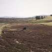
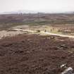
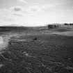
Situated on a S-facing slope at NO 078 483 is an extensive settlement comprising 14 oval and circular stone-walled huts and a well-preserved field system.
Many of the huts have good outer faces of large boulders and four are double-walled. The entrances of all the huts are on the SE or SSE with one, a double-walled hut of 14.0m outside diameter having a single door jamb flanking the entrance. This hut too, is unusual in that the outer wall expands on the NE to form an annexe. The average diameter of the single-walled huts varies between 14.0m and 8.5m whilst the double-walled huts average 13.5m external diameter and 8.5m internally. The field system is marked by stone clearance heaps, lynchets, and rickles of stones from ruined field walls.
Surveyed at 1:10,000.
Visited by OS (AA) 30 January 1975
Field Visit (October 1987)
NO04NE 6.00 078 483
NO04NE 6.01 NO 0760 4844 Hut-Circles; Field System
NO04NE 6.02 NO 0760 4844 Hut-Circles; Field System
NO04NE 6.03 NO 0762 4848 Hut-Circles; Field System
NO04NE 6.04 NO 0764 4847 Hut-Circles; Field System
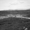
Situated on the heather-covered slopes to the E of Craigend, there are three groups of hut-circles, a field-system and numerous small cairns. To the S of the western group of houses there are at least 25 small cairns measuring up to 5m by 0.5m, and faint traces of rig-and-furrow cultivation. To the SSE of house 6, and E of 7 there are several stretches of field bank. On the slope below houses 7-12, there is a large number of small cairns measuring up to 7m in diameter by 0.5m in height: several show signs of disturbance.
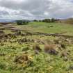
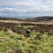
1. NO 0760 4844 A large hut-circle measuring 11m in diameter within a wall 2.2m in thickness and 0.3m in height. A considerable proportion of the outer face is visible but only short stretches of the inner face can be seen; the entrance lies on the SSE. Short lengths of walling spring from the N and NE arcs to link the hut-circle to (No. 2), and the resulting enclosure is entered through a gap on the SE.
2. NO 0761 4846 This hut-circle measures 7.75m in average diameter within a wall 2.6m thick and 0.3m high. On the N a large boulder has been incorporated into the outer face, and the inner face is composed of slabs set on edge; the entrance is on the SSE. The interior has been levelled into the slope.
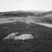
3. NO 0762 4848 This hut-circle is 8.5m in diameter within a wall 3.8m thick and 0.25m high; there are considerable stretches of the outer face visible and the inner face consists of upright slabs. The entrance, which is on the E, has large slabs on its E side.
4. NO 0764 4847 This hut-circle measures 8.2m in diameter within a wall 3.3m thick and 0.3m high. Long stretches of outer facing stones are visible and the inner face is composed of upright slabs. The entrance is on the SSE.
5. NO 0780 4841 Situated at a break in slope, this hut-circle measures about 10.9m in diameter within a wall 1.9m thick and 0.25m in maximum height. Several stretches of the well-built inner face are visible and at least two outer facing-stones can be seen; the entrance is on the S. 6. NO 0810 4839 This massively built hut-circle, which is situated at the foot of a slight rise, measures 9.75m in diameter within a wall 2.6m thick and up to 0.6m high. To either side of the entrance, which lies on the S, the wall is particularly well-preserved with outer facing stones measuring up to 1.5m in length still in situ; elsewhere the weight of the core material has caused the facing stones to slump outwards. In contrast, the inner face is barely visible, being composed of much smaller stones. There is a slight rise in the centre of the interior.
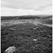
7. NO 0809 4830 Situated at the edge of a scarp, this unusual building resembles a double Dalrulzian house, but it lacks the inner wall to the E portion. The W half measures 7.5m in diameter within a wall 1.4m thick and 0.25m high; the entrance, which lies on the ESE, is 1m wide. The E half measures 15.9m over a wall 2.3m thick and 0.4m high, and was entered from the S.
8. NO 0805 4831 This hut-circle lies at the edge of a scarp; it measures 7.8m in diameter within a wall 2.06m thick and up to 0.4m high. There are several substantial outer facing-stones and the entrance is on the SSE. A bank springs from the W side of the entrance and runs diagonally down the slope to the SW.
9. NO 0795 4831 The wall of this unusual hut-circle comprises a ring of stones revetted internally by a number of large inner facers. The wall is up to 1.3m thick and 0.25m high and encloses an area 8.4m in diameter. The interior is levelled into the slope, and the entrance lies on the SSE.
10. NO 0792 4829 A large hut-circle, which on the date of visit was obscured by deep heather, occupies a terrace at the foot of a scarp; it measures 12.3m in diameter within a wall 2.1m thick and 0.3m high. At the entrance (on the SSE), which is 2m wide, there are a number of large outer facing-stones that have slumped outwards. It is probable that this is a Dalrulzian house with the inner wall hidden by the heather.
11. NO 0791 4828 This small hut-circle measures 3.25m in diameter within a wall 1.9m thick and 0.3m high with a possible entrance on the SSW.
12. NO 0789 4831 This hut measures 2.5m in diameter within a wall 1.5m thick and 0.3m high; the position of the entrance is uncertain.
13. NO 0793 4831 This rectangular hut (aligned E-W), possibly a shieling-hut, measures 5.2m by 2.2m within a wall 1m thick. The entrance is centrally placed on the S side.
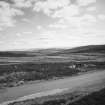
14. NO 0768 4817 Situated immediately E of a trackway, this hut-circle measures 7.9m in diameter within a wall 1.65m thick and 0.2m high. The entrance is on the SSE, and there is a spur of bank that springs from the NW and what may be traces of another on the SW.
15. NO 0764 4816 This tangential pair of hut-circles measures 5.4m and 4.8m in diameter respectively within walls 2m and 1.9m thick by up to 0.25m high. The entrances are on the SE and SSE respectively. Immediately SW of the southernmost of the hut-circles there are the remains of two possible turf huts, and surrounding them are traces of rig-and-furrow cultivation.
Visited by RCAHMS (JBS) October 1987.
RCAHMS 1990
Project (July 1994)
In order to carry out the Archaeological requirement of an environmental assessment at the proposed locations of three windfarms, a programme of documentary and archival research and field survey was undertaken by GUARD in July 1994. The work was commissioned by Energy Unlimited on behalf of The New World Power Company Limited. Of the three sites examined, Hart Hill (SC03), was the only one to be free of archaeological structures. The two remaining sites Drumderg (SC01) and Dulater Hill (SC04) have a number of archaeological structures in the immediate area but few in the proposed construction area. With slight modifications in layout and careful planning these should not be an obstacle to the proposed projects.
GUARD 1994

