
Following the launch of trove.scot in February 2025 we are now planning the retiral of some of our webservices. Canmore will be switched off on 24th June 2025. Information about the closure can be found on the HES website: Retiral of HES web services | Historic Environment Scotland
Glen Cochill


Building (Medieval) - (Post Medieval), Cairnfield (Medieval) - (Post Medieval), Enclosure (Medieval) - (Post Medieval), Field Boundary(S) (Medieval) - (Post Medieval), Rig And Furrow (Medieval) - (Post Medieval), Shieling Hut(S) (Medieval) - (Post Medieval)
Site Name Glen Cochill
Classification Building (Medieval) - (Post Medieval), Cairnfield (Medieval) - (Post Medieval), Enclosure (Medieval) - (Post Medieval), Field Boundary(S) (Medieval) - (Post Medieval), Rig And Furrow (Medieval) - (Post Medieval), Shieling Hut(S) (Medieval) - (Post Medieval)
Canmore ID 26255
Site Number NN94SW 4
NGR NN 902 408
NGR Description centred on NN 902 408
Datum OSGB36 - NGR
Permalink http://canmore.org.uk/site/26255


- Council Perth And Kinross
- Parish Little Dunkeld
- Former Region Tayside
- Former District Perth And Kinross
- Former County Perthshire
Field Visit (20 November 1970)
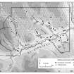
NN94SW 4 centred on 902 408.
In this area, generally within an old field wall, are the remains of at least 10 oval to circular turf or stone shielings varying from 1.8m to 4.0m in diameter and 0.3m to 0.7m in height.
Visited by OS 20 November 1970.
Field Visit (6 December 1993 - 7 December 1993)
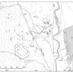
On the W side of Glen Cochill, where the ground begins to rise from the valley floor, and about 500m to the SW of the White Cairn (NN94SW 2) there is a group of about 20 shieling-huts, numerous small cairns, patches of rig and short lengths of bank, mostly located within an oval enclosure about 6ha in extent. The site is immediately to the SW of a field-system (NN94SW 1), and at least some of the recorded features were probably originally part of that monument.
The enclosure is defined by a stony bank 1.5m thick and 0.5m high, in places faced with large boulders. The huts are concentrated in two groups towards the E and N sides of the enclosure. There is a third group of huts 150m NW of the N end of the enclosure (Braan93 292-5) and two outlying huts to the S (Braan93 282-3). With one exception they measure between 2m and 4.7m in length and between 1.6m and 3.1m in breadth within walls between 0.7m and 1m in thickness, although these have often collapsed and spread. The exception (Braan93 294) is much larger and measures 6.9m in length by 3.5m in breadth, with a rounded N end. Several huts (Braan93 272, 274, 278, 280, 286, 290 and 291) have an attached outshot and mounds outside two huts (Braan93 272, 286) may be middens. Five huts are built against or over the enclosure bank (Braan93 274-5, 280-2).
In the W half of the enclosure there are fragments of rig, with furrows spaced 4m apart, though there are some traces of sub-division into narrower rigs. The small cairns are also concentrated in W half of the enclosure, although these also spread farther to the NW and to the S. They measure up to about 4m in diameter and 0.5m in height. The relationship of the rig and the cairns with the huts the enclosure, and indeed with each other, must remain uncertain, but more than one phase of activity is indicated by a trackway approaching from the SE which has been blocked by the enclosure wall.
(Braan93 272-84, 286-96)
Visited by RCAHMS (SDB) 6 and 7 December 1993

