
Rossie Law


Fort (Prehistoric)
Site Name Rossie Law
Classification Fort (Prehistoric)
Alternative Name(s) Garrison Law
Canmore ID 26046
Site Number NN91SE 1
NGR NN 99767 12427
Datum OSGB36 - NGR
Permalink http://canmore.org.uk/site/26046


First 100 images shown. See the Collections panel (below) for a link to all digital images.
- Council Perth And Kinross
- Parish Dunning
- Former Region Tayside
- Former District Perth And Kinross
- Former County Perthshire
Reference (1857)
'The next station is the Garrison Law, nearly three miles south east from Dunning. It is very steep, and has been surrounded by a single ditch and rampart some distance below the summit, about five hundred yards in circumference, which must have made it almost impregnable'.
Miller, Lieut. Col., An Inquiry respecting the SIte of the Battle of Mons Graupius, 1857, p49
Reference (1860)
Rossie Law. This name is applied to a British fort surrounding the summit of Rossie Law. In the new Stat. Acct. this object is spoken of as a Roman Camp but from its elevated site and peculiar situation being the summit of a conical shaped hill and also from its shape etc, it is not at all likely to have been constructed by the Romans but must be regarded as a British hill fort.
Ordnance Survey Name Book 25 inch, Perthshire 26, 90.
Publication Account (1899)
Transcript of David Christison's description of Rossie Law, read to the Society of Antiquaries of Scotland in December 1899, and published in Volume 34 of their Proceedings, in 1900:
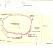
No. 33. 1 ½ mile further NNE [from Ben Effrey], and 3m of Auchterarder, is a fort on Rossie Law, 1064ft above the sea and 900m above the valley. A single oval ‘Ring’, about 600 by 500 ft on the Ordnance Survey map, surrounds the top (fig. 31, plan). The actual top is a level, dry, grassy, pleasant space, A, of about 270 by 150 ft. The ring approaches it on the S within about 30ft and at a lower level of 10ft, but separates from it on the N till it is 300ft distant and about 70ft lower. The approaches are long and difficult, usually steepest on reaching the ring, when they ease off to the top. From the W and S the descents are rocky and almost inaccessible. It is only for a small space on the E that the approach is gentle. On the E and N the defence remaining is a grassy and stony mound, 15ft broad at the entrance, which is from the E. I could see no masonry, but in one part, for a stretch of about 100ft, there is a row of large stones, 2 to 3 ft in length, placed at the lower edge of the stony mound, and 7 ft below its top (elevation and section, D), perhaps the base of a former wall built on the slope. A very large stone lies uncovered at the entrance. On the inaccessible S and W sides there is no mound or wall, but merely a terrace at the edge of the descent; and there is no sign of an inner defence for the level top.
Field Visit (12 May 1956)
Fort, Rossie Law. A large fort bounded by a single wall which follows the shoulder of the hill and is only interrupted by an entrance on the SE and a rock outcrop on the SW. The wall had double facings of boulders and a solid core of small stones derived from an internal quarry terrace. It is heavily ruined at the present time, and exhibits facings only at the entrance where it is about 14ft in thickness.
There are no definite signs of internal structures, although a number of slight, irregularly-shaped scoops on the slopes that flank the flat summit on the N and W may be hut sites. They are, however, nothing like as distinct as the Eildon huts, and may simply be surface quarry pits.
Visited by RCAHMS (KS) 12 May 1956
Notebook MS 36/176
Publication Account (1963)
This fort is one of the largest of those which occupy peaks on the N face of the Ochil range overlooking lower Strathearn from the S. It is formed by a single wall which measures 14ft in thickness in places and which encloses an area 600ft in length by 500ft in width. Very slight traces of platforms or scoops which can be distinguished in parts of the interior might represent traces of the sites of timber-framed buildings.
Feachem 1963 (1977 edn, 146)
Desk Based Assessment (17 June 1966)
NN91SE 1 997 124.
(NN 997 124) Fort (NR)
OS 6" map, (1959)
This fort is formed by a single wall 14ft thick in places enclosing an area 600ft by 500ft. Very slight traces of platforms or scoops which can be distinguished in parts of the interior might represent the sites of timber framed buildings (Feachem 1963).
Information from OS (DJC) 17 June 1966
Sources: D Christison 1900; R W Feachem 1963.
Field Visit (16 June 1967)
Generally as described above [OS 1966]. The enclosing wall, partially grass covered, is in an extremely ruinous condition. The interior shows no definite evidence of platforms or scoops.
Visited by OS (R D) 16 June 1967.
Aerial Photography (1984)
Excavation (9 June 2012 - 23 June 2012)
NN 99771 12416 Four trenches were excavated, 9–23 June 2012, across the hillfort at Rossie Law. A 20 x 2m trench dug across the bank on the SE side of the fort revealed evidence for two timber palisades, which were constructed on the mid-slope of the hill, c5m apart. Behind the uppermost palisade a lens of burnt timber was overlain by several layers of midden upon which a rough stone bank, c4m wide, was constructed. The stone for the bank was quarried from outcropping bedrock within the fort. Fragments of prehistoric pottery were retrieved within a quarry hollow behind the bank. A second trench was deturfed over the bank on the NE side of the fort, but due to a lack of time it was not fully excavated.
On the summit of the Rossie Law two further trenches were excavated. A quarter of a circular hollow on the summit of the hill was examined in an 8 x 8m trench. The excavation found that a natural hollow which retained water was further augmented and contained by a low stone and earth bank. The second 8 x 3m trench on the summit of the hill contained evidence for post-medieval disturbance of earlier, potentially prehistoric, deposits. The main feature recorded in this trench was a circular stone slab setting for a fire measuring
Archive: University of Glasgow and RCAHMS (intended)
Funder: Historic Scotland and University of Glasgow
Tessa Poller, University of Glasgow
2012
Project (7 March 2012 - 17 March 2012)
NN 99771 12416 A geophysical survey was carried out 7–9 and 17 March 2012 on Rossie Law in advance of excavation. The gradiometry survey covered c10000m2 across the summit of the E end of the hill, up to and including the summit of the bank. The underlying volcanic geology dominated the results of the gradiometry survey on the summit of the hill and therefore any potential subtle magnetic archaeological features could not be detected. However, lower down the slope, along the inner edge of the enclosing bank, possible traces of an internal ditch were noted. Opposite the entrance several potential archaeologically significant anomalies were also detected. A small area of resistivity on the summit highlighted the edge and centre of a circular hollow as an area of higher resistance.
Archive: University of Glasgow and RCAHMS (intended)
Funder: Historic Scotland and University of Glasgow
Tessa Poller, University of Glasgow
, Northlight Heritage
2012
Earth Resistance Survey (7 March 2012 - 17 March 2012)
NN 99771 12416 A geophysical survey was carried out 7–9 and 17 March 2012 on Rossie Law in advance of excavation. A small area of resistivity on the summit highlighted the edge and centre of a circular hollow as an area of higher resistance.
Archive: University of Glasgow and RCAHMS (intended)
Funder: Historic Scotland and University of Glasgow
Tessa Poller, University of Glasgow
Northlight Heritage
2012
Magnetometry (7 March 2012 - 17 March 2012)
NN 99771 12416 A geophysical survey was carried out 7–9 and 17 March 2012 on Rossie Law in advance of excavation. The gradiometry survey covered c10000m2 across the summit of the E end of the hill, up to and including the summit of the bank.
Archive: University of Glasgow and RCAHMS (intended)
Funder: Historic Scotland and University of Glasgow
Tessa Poller, University of Glasgow
Northlight Heritage
2012
Laser Scanning (2012)
A 3D laser scan was also produced of the hill including the bank of the fort. This work was undertaken by Charlotte Francoz of Northlight Heritage in conjunction with the University of Glasgow.
Archive: University of Glasgow and RCAHMS (intended)
Funder: Historic Scotland and University of Glasgow
Tessa Poller, University of Glasgow, Northlight Heritage 2012
Note (24 December 2014 - 25 October 2016)
This fort is situated on the summit of Rossie Law, which is a steep-sided local summit on a spur dropping down the N face of the Ochils between Banekist Burn on the W and Scores Burn on the E. The summit of the hill rises some 50m above the saddle that separates it from the rest of the spur on the S, and there is also a precipitous crag on this flank. The defences comprise a single wall reduced to a bank a little over 4m in thickness, which extends around the shoulder of the hill above the crags to enclose an area measuring about 215m from E to W by 135m transversely (2.3ha). There is a single entrance on the SE, which in 1956 was the only place where RCAHMS investigators observed the remains of the wall faces; within the interior they also observed traces of several shallow scoops but hesitated from identifying any of them as house platforms. A geophysical survey was carried out in 2012 prior to excavations which sectioned the defences on the SE and sampled two places within the interior. The trench across the defences revealed that the wall had been roughly built with stone quarried from the interior; it overlay earlier midden deposits and outside its line there were two palisade trenches set some 5m apart. A circular hollow that retained water on the summit was shown to be a natural feature with a low bank on its lip.
Information from An Atlas of Hillforts of Great Britain and Ireland – 25 October 2016. Atlas of Hillforts SC2646
Field Visit (19 May 2016)
This univallate fort is situated on the summit of Rossie Law at the N edge of the Ochils from whence it enjoys a fine outlook over Strathearn. It is oval on plan, measuring 200m from E to W by 121m transversely within an eroded grass- and heather-grown stony rampart up to 7m thick and 2m high externally. Although it is comparatively well-preserved around much of its circuit, it is reduced to little more than a terrace in places, especially on the W and SSW. Outer facing-stones are visible intermittently at its foot on the N, NE, SW and NW, while its crest is surmounted by the remains of a later turf wall up to 1m thick and 0.2m high, which is most readily detected on the E. The rampart is interrupted by a rocky outcrop on the S and by two simple gaps on the ESE. The more northerly is an original entrance, with the rampart terminals rising gently as they approach one another, while also curving slightly inwards. The deeply cut gap between them measures about 5m wide and up to 2m deep, but is shallower on the N where there has been less attrition by traffic. The more southerly gap, by contrast, breaches the defences (including the turf wall) and rises over the stump of the rampart. Probably a cart track of comparatively recent date, it measures 5m wide, but only 0.8m deep; and it is approached by an external ramp. Two facing-stones are exposed in a later pit to the N of this entrance, while the crest of the rampart immediately adjacent has been levelled.
Running behind the rampart are the distinct, but intermittent rush- and grass-grown traces of the quarrying that provided the material for the rampart. Beyond this the ground rises in a series of broken slopes and natural terraces until a broad, roughly flat-topped, grass-grown summit is reached on the S side of the fort. Internal features are few, but there are a number of eroded platforms, particularly on the steep N and SW scarps, which could be taken for the stances of buildings. While most appear to be natural features, at least two situated on the summit seem to be authentic. The best preserved, which is circular and measures about 7m in diameter, is cut into the rising ground on the W; but the low arc of a bank situated immediately N of a deep circular hollow near the centre of the summit may represent the remains of another. This hollow is the most distinctive feature within the fort's interior. It is surrounded by a stony bank measuring 1m thick and 0.2m high on all except the N side. Its dished interior measures about 9m in diameter and 0.5 deep.
Three cuttings made during the excavations of 2012 can still be detected (Poller and James 2012): one spans the defences SE of the secondary entrance (Trench 1); another quarters the circular hollow on the summit (Trench 2); while a third lies over what was thought to be a building platform situated about 9m NW of the latter (Trench 4). The fourth (Trench 3), spanning the defences on the NW side of the earthwork, was not located during the survey.
Taken together, the excavation indicates that the fort had a more complex structural history than is to be inferred from surface observation alone. At least two, possibly contemporary, palisades had preceded the construction of the stony bank, while the few sherds of pottery retrieved suggested that the fort's origin lay in the Late Bronze Age or Early Iron Age. Although hearths associated with burnt bone were noted at the edge of the natural hollow on the summit, the latter had probably been a pond. This was subsequently modified through the addition of a surrounding bank, which contained clear glass and slag - probably indicative of a post-medieval date. Traces of a stone setting for a bonfire to its NW may also have belonged to this period.
Visited by HES, Survey and Recording (ATW, GFG) 19 May 2016.
Project (1 May 2016 - 12 May 2017)
Archaeological features were identified and mapped from airborne remote sensing sources, such as lidar, historic vertical aerial photographs, and 25cm orthophotographs.
Information from HES (OA) 12 May 2017

