
Bute, Lubas


Farmhouse (19th Century), Farmstead (19th Century)
Site Name Bute, Lubas
Classification Farmhouse (19th Century), Farmstead (19th Century)
Alternative Name(s) Farm House
Canmore ID 233469
Site Number NS05SE 38
NGR NS 08688 54598
Datum OSGB36 - NGR
Permalink http://canmore.org.uk/site/233469


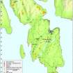

- Council Argyll And Bute
- Parish Kingarth
- Former Region Strathclyde
- Former District Argyll And Bute
- Former County Buteshire
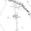
NS05SE 38.00 Farmhouse 08688 54598
NS05SE 38.01 Southern range
NS05SE 38.02 South-east range
NS05SE 38.03 North-east range
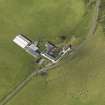
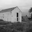
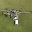
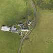
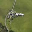
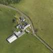
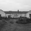
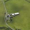
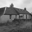
Lubas is a working farmsteading that comprises a mixture of 19th century buildings and modern sheds. It was not recorded in detail on the date of visit.
The farmstead is depicted on Roy’s Military Map (1747-55) but shown in more detail on a contemporary estate map (Foulis 1758-9). At this time Lubas comprised two groups of buildings about 200m apart, the southern containing four buildings and the northern two. The 19th century steading, which probably developed from the northern group, is depicted on the 1st edition of the OS 6-inch map (Buteshire 1869, Sheet CCXV). It comprised two long buildings flanking the public road. Subsequently the road was redirected around the E side of the steading and another range was added to its S side before the second edition of this map was published (Buteshire 1897, Sheet CCXV.SW). Nothing is now visible in cultivated ground of the southern element of the 18th century steading.
Visited by RCAHMS (GFG, SG) 21 July 2009.
Antiquarian Mapping (1747 - 1755)
Antiquarian Mapping (1758 - 1759)
Field Visit (21 July 2009)
Lubas is a working farmsteading that comprises a mixture of 19th century buildings and modern sheds. It was not recorded in detail on the date of visit.
The farmstead is depicted on Roy’s Military Map (1747-55) but shown in more detail on a contemporary estate map (Foulis 1758-9). At this time Lubas comprised two groups of buildings about 200m apart, the southern containing four buildings and the northern two. The 19th century steading, which probably developed from the northern group, is depicted on the 1st edition of the OS 6-inch map (Buteshire 1869, Sheet CCXV). It comprised two long buildings flanking the public road. Subsequently the road was redirected around the E side of the steading and another range was added to its S side before the second edition of this map was published (Buteshire 1897, Sheet CCXV.SW). Nothing is now visible in cultivated ground of the southern element of the 18th century steading.
Visited by RCAHMS (GFG, SG) 21 July 2009.
Reference (2009)
Publication Account (2009)
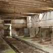
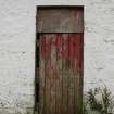
Lubas Farm is situated in the south west of Bute, in pasture fields 1km north of Dunagoil and 500m east from Lubas Bay. It is a good example of a smaller farm, relatively unspoilt, which retains slate roofs and patterns of fenestration from its early nineteenth century reconstruction. The tenant will be vacating the property in November and it may be refurbished by the estate. An estate map of ‘Lubaz’ by Foulis in 1758–9 depicted two groups of buildings flanking a road. Much later, and after reconstruction, the 1869 Ordnance Survey map showed the three bay farmhouse, more like a cottage in proportions and size, with a long range aligned north and south,attached to the east gable, and yards and garden to the north and west. Across the old road to the east there was another, longer and higher range, this time with a stepped ridge. By 1897 a single storey south range was added between the earlier two forming a U-plan courtyard, and the road to Dunagoil and Garrochty was moved to the east to skirt the farm. It was later developed with the addition of two horse gins and another range to the south west before 1919; larger sheds were built to the west in the later twentieth century. Importantly, the buildings retain a sense of the proportions, layout and workings of a small nineteenth century Bute farm; surviving boarded doors, sash and case windows and slit openings are characteristic details which may be lost during a restoration project.
Information from ‘The Royal Commission on the Ancient and Historical Monuments of Scotland, Commissioners’ Field Meeting 2009'.

